Download
1 / 16
210 likes | 431 Views
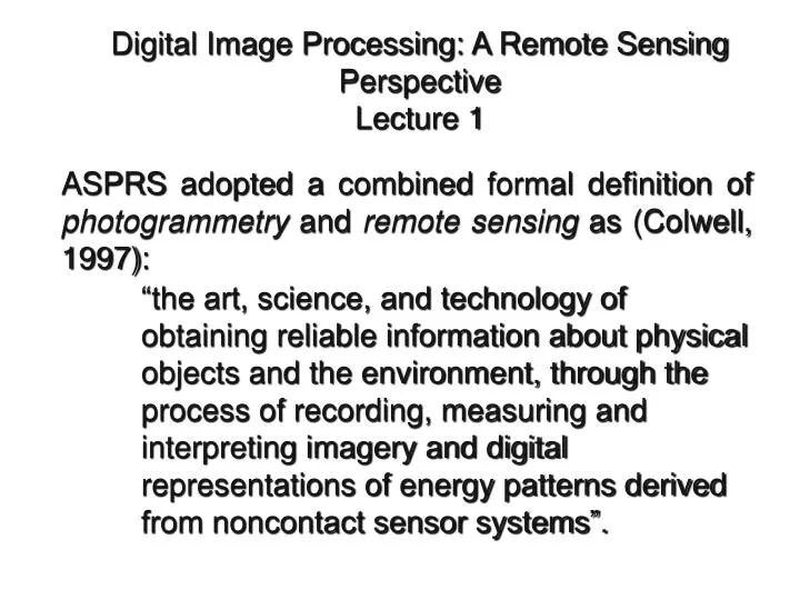
Digital Image Processing: A Remote Sensing Perspective Lecture 1. ASPRS adopted a combined formal definition of photogrammetry and remote sensing as (Colwell, 1997):

E N D
Digital Image Processing: A Remote Sensing Perspective Lecture 1 • ASPRS adopted a combined formal definition of photogrammetry and remote sensing as (Colwell, 1997): • “the art, science, and technology of obtaining reliable information about physical objects and the environment, through the process of recording, measuring and interpreting imagery and digital representations of energy patterns derived from noncontact sensor systems”.
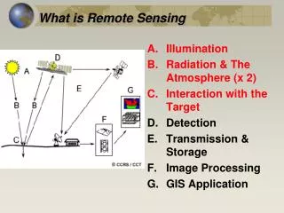
A remote sensing instrument collects information about an object or phenomenon within the instantaneous-field-of-view (IFOV) of the sensor system without being in direct physical contact with it. The sensor is located on a suborbital or satellite platform.
Is Remote Sensing a Science? A science is defined as the broad field of human knowledge concerned with facts held together by principles (rules). Scientists discover and test facts and principles by the scientific method, an orderly system of solving problems. Scientists generally feel that any subject that humans can study by using the scientific method and other special rules of thinking may be called a science. The sciences include 1) mathematics and logic, 2) the physical sciences, such as physics and chemistry, 3) the biological sciences, such as botany and zoology, and 4) the social sciences, such as geography, sociology, and anthropology.
Remote sensing is a tool or technique similar to mathematics. Using sensors to measure the amount of electromagnetic radiation (EMR) exiting an object or geographic area from a distance and then extracting valuable information from the data using mathematically and statistically based algorithms is a scientific activity. It functions in harmony with other spatial data-collection techniques or tools of the mapping sciences, including cartography and geographic information systems (GIS) (Clarke, 2001).
Information about an Object or Area Sensors obtain specific information about an object (e.g., the type or classification of the wetalnd ) or the geographic extent of a phenomenon (e.g., the upland- wetland boundary The EMR reflected, emitted, or back-scattered from an object or geographic area is used as a surrogate for the actual property under investigation. USFWS photo
Advantages of Remote Sensing Remote sensing is unobtrusive if the sensor passively records the EMR reflected or emitted by the object of interest. Passive remote sensing does not disturb the object or area of interest. Remote sensing devices may be programmed to collect data systematically, such as within a 9 9 in. frame of vertical aerial photography. This systematic data collection can remove the sampling bias introduced in some in situ investigations. Under controlled conditions, remote sensing can provide fundamental biophysical information, including x,y location, z elevation or depth, biomass, temperature, and moisture content. What and Where
Limitations of Remote Sensing The greatest limitation is that it is often oversold. Remote sensing is not a panacea that provides all the information needed to conduct physical, biological, or social science research. It provides some spatial, spectral, and temporal information of value in a manner that we hope is efficient and economical. Human beings select the appropriate remote sensing system to collect the data, specify the various resolutions of the remote sensor data, calibrate the sensor, select the platform that will carry the sensor, determine when the data will be collected, and specify how the data are processed. Human method-produced error may be introduced as the remote sensing instrument and mission parameters are specified.
Powerful active remote sensor systems that emit their own electromagnetic radiation (e.g., LIDAR, RADAR, SONAR) can be intrusive and affect the phenomenon being investigated. Additional research is required to determine how intrusive these active sensors can be. Remote sensing instruments may become uncalibrated, resulting in uncalibrated remote sensor data. Remote sensor data may be expensive to collect and analyze. Hopefully, the information extracted from the remote sensor data justifies the expense.
Problems Associated with In Situ Data Collection Scientists can collect data in the field using biased procedures often referred to as method-produced error. Such error can be introduced by: sampling design does not capture the spatial variability of the phenomena under investigation (i.e., some phenomena or geographic areas are oversampled while others are undersampled) improper operation of in situ measurement instruments uncalibratedin situ measurement instruments.
Spectral Resolution Jensen, 2004
Airborne Visible Infrared Imaging Spectrometer (AVIRIS) Datacube of Sullivan’s Island Obtained on October 26, 1998 Color-infrared color composite on top of the datacube was created using three of the 224 bands at 10 nm nominal bandwidth. Jensen, 2004
Spatial Resolution Jensen, 2004
Temporal Resolution Remote Sensor Data Acquisition June 1, 2004 June 17, 2004 July 3, 2004 16 days Jensen, 2004
Radiometric Resolution 7-bit (0 - 127) 0 8-bit (0 - 255) 0 9-bit (0 - 511) 0 10-bit (0 - 1023) 0 Jensen, 2004