Download
1 / 1
10 likes | 85 Views
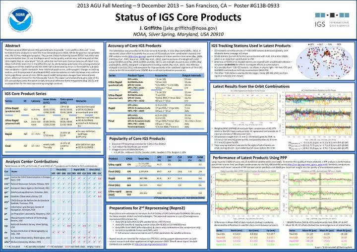
2013 AGU Fall Meeting – 9 December 2013 – San Francisco, CA – Poster #G13B-0933 Status of IGS Core Products J. Griffiths (jake.griffiths@noaa.gov) NOAA, Silver Spring, Maryland, USA 20910. Abstract. Accuracy of Core IGS Products. IGS Tracking Stations Used in Latest Products.

E N D
2013 AGU Fall Meeting – 9 December 2013 – San Francisco, CA – Poster #G13B-0933 Status of IGS Core Products J. Griffiths (jake.griffiths@noaa.gov) NOAA, Silver Spring, Maryland, USA 20910 Abstract Accuracy of Core IGS Products IGS Tracking Stations Used in Latest Products The International GNSS Service (IGS) generally aims to provide ~1 cm satellite orbits and ~1 mm terrestrial frame products to meet the most demanding user needs. While the goal has not yet been met, the IGS has made good progress. The current Global Positioning System (GPS) Final orbits have accuracies better than 2.5 cm; the Rapids are of similar quality; and the near real-time parts of the Ultra-rapids have an accuracy of ~3.0 cm, while the real-time parts have an accuracy of about 5 cm. About half of the total error in the GPS orbits can be attributed to systematic time-varying rotational misalignment of the orbital frames; the other half is dominated by errors in the model for sub-daily tidal variations in Earth orientation. Near-field multi-path errors, anthropogenic changes at tracking stations, and the presence of uncalibrated GNSS antenna radomes at multi-technique sites continue to be a significant source of error. While recent model and analysis changes have reduced some errors, others will remain for the foreseeable future. This paper summarizes the quality state of the IGS core products since the switch to daily terrestrial reference frame integrations (Aug. 2012), and as preparations for the next reprocessing campaign continue. • IGS network currently consists of ~430 GNSS stations distributed globally, with relatively dense coverage in Europe • 92 IGS stations (current & former) are co-located with VLBI, SLR and/or DORIS, which is an important contribution to ITRF • Antennas at 30.4% of co-located stations are covered with uncalibratedradomes—see poster G13B-0946 for efforts to mitigate effects at some stations • ACs use data from ~326 IGS stations—as shown in plot to right—for their GPS and GLONASS contributions to Finals combinations (Wk 1765) • The other ~145 stations used by the ACs (again, Finals GPS Wk 1765) are from regional networks (not shown) The table below was presented at the EGU General Assembly in 2012 [Ray and Griffiths, 2012]. It represents a best effort to quantify the accuracy of IGS products from: combination statistics and PPP analysis results (http://acc.igs.org); spectral analyses of station position time series [Ray, 2006; Collilieuxet al., 2007; Ray et al., 2008; Ray et al., 2013]; spectral analyses of midnight GPS orbit jumps [Griffiths and Ray, 2009; Griffiths and Ray, 2013 ] and midnight discontinuities in ERPs [Ray and Griffiths, 2011]; along with comparisons to loading models [Ray et al., 2011]. Very little has changed since EGU 2012, with exception for improvements in the rotational alignment of Final GPS orbits to the IGS terrestrial frame (IGb08) due to refined combination procedures. Latest Results from the Orbit Combinations IGS Core Product Series • Weighted RMS (WRMS) of residuals from comparisons of AC GPS orbits to the IGS Finals measure inter-AC agreement and provide an internal estimate of IGS precision (1D) • IGS precision ranges from 11 mm (= 16 mm/√2) given by EMR, to 4.5 mm (= 6.4 mm/√2) given by ESA, and possibly down to 3.5 mm (= 5 mm/√2) given by IGR • Time-varying rotations (see plot to the right) of orbit frames are small, but significant—dominated by ESA issues before Wk 1730 Popularity of Core IGS Products • RX[(IGS-IGR)/2]= -9.2 (± 62.2) μas, or -1.2 (± 8.1) mm shift @ GPS • RY[(IGS-IGR)/2]= -20.5 (± 73.5) μas, or -2.7 (± 9.5) mm shift @ GPS • RZ[(IGS-IGR)/2]= 14.8 (± 55.9) μas, or -1.9 (± 7.3) mm shift @ GPS • Based on FTP download statistics for 1/2012 thru 6/2012 • >3.6 million file downloads per month • 5 biggest users of CDDIS/IGS files: • U.S. 64.3%, Indonesia 19.3%, Canada 1.64%, Sweden 1.57%, Belgium 1.16% Performance of Latest Products Using PPP Analysis Center Contributions Large majority (>80%) of users rely on combined satellite orbits and clocks. To monitor the quality of these products, a PPP analysis is performed as part of the routine Final and Rapid combinations for the IGS, IGR and IGA series (http://acc.igs.org/index_igsacc_ppp.html). Similarity comparisons between each series’ network of PPP-derived station positions and IGb08 give important insight into the quality of the combined products. Table focuses on GPS; all GLO-only (+) and GNSS AC (*) products are included in GLO combinations. FTP download logs courtesy of C. Noll (NASA/CDDIS) Preparations for 2nd Reprocessing (Repro2) • Preparations are underway to reanalyze the full-history of GPS (and maybe GLONASS) data using the latest analysis models and methodologies. The expected outcome is a set of homogeneous reprocessed IGS solutions for: • daily GPS & GLO orbits & GPS satellite clocks in SP3 format • daily GPS satellite & tracking station clocks (5m & 30s) in CLK RINEX format • daily ERPs from SINEX (official product) & classic orbit combinations (for comparison only) • terrestrial coordinate frames with ERPs, with • full variance-covariance matrix and Z-offset parameters for satellite antennas • Repro2 results are intended for inclusion in ITRF2013, and to support advancements in Earth science research and other applications of high-precision GNSS. Details about repro2 analysis standards are available at: http://acc.igs.org/reprocess2.html. • Differences in Mean RMS of daily residuals (below) is probably dominated by differences in satellite clock errors between products. • ~180d RZ feature (IGR & IGS) predominantly from EMR, JPL & MIT • Mean RX, RY, RZ offsets (below) due to misalignment of orbital frame = AC included = AC partially included = AC excluded brd = excl. brdc clock empty = none 1 µas = ~0.03 mm shift @ Earth surface