Download
1 / 37
370 likes | 659 Views
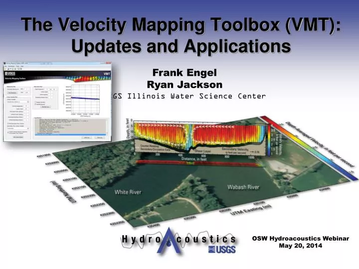
Frank Engel Ryan Jackson USGS Illinois Water Science Center. The Velocity Mapping Toolbox (VMT): Updates and Applications. OSW Hydroacoustics Webinar May 20, 2014. Opening Demo. A quick look at VMT

E N D
Frank Engel Ryan Jackson USGS Illinois Water Science Center The Velocity Mapping Toolbox (VMT): Updates and Applications OSW HydroacousticsWebinar May 20, 2014
Opening Demo • A quick look at VMT • Reads TDRI ASCII files (multiple transects) • Averages to one Mean Cross Section (MCS) • Quickly allows for robust visualization • [VMT demo outside of presentation]
Contributors to VMT Primary Developers: • Ryan Jackson (USGS Illinois WSC) • *Frank Engel (USGS Illinois WSC) • Dan Parsons (Univ. of Hull, UK) • Jon Czuba (former USGS) • Dave Mueller (USGS OSW) Input and support from: • Kevin Oberg (USGS OSW) • Bruce Rhoads (University of Illinois) • Kevin Johnson (USGS Illinois WSC) • Jim Best (University of Illinois) • Marcelo Garcia (University of Illinois) • Jim Riley (Eastern Illinois University) • Ricardo Szupiany (Universidad Nacional del Litoral, Argentina) • And many others! Engel Jackson Mueller Czuba Parsons VMT *Current primary coder
Timeline Mathworks consultation Sep 2012 Czuba St. Claire work ESPL paper Summer 2008 Oct 2012 Parsons & Best Parana work Engel begins contributing VMT version 4 released Aug 2009 2006 May 2013 Riley confluence work Feb 2007 VMT fact sheet Jackson builds VMT v1 May 2013 Dec 2008 2006 2007 2008 2009 2010 2011 2012 2013 2014 2nd velocity mapping class Tampa short course Mar 2011 May 2014 Santa Fe, Argentina short course 1st velocity mapping class Sep 2013 Sep 2009 • Basic Matlab codes developed by Dan Parsons • Transect averaging • Secondary flow computation • Site specific Snowbird short course Aug 2012
Timeline Mathworks consultation Sep 2012 Czuba St. Claire work ESPL paper Summer 2008 Oct 2012 Parsons & Best Parana work Engel begins contributing VMT version 4 released Aug 2009 2006 May 2013 Riley confluence work Feb 2007 VMT fact sheet Jackson builds VMT v1 May 2013 Dec 2008 2006 2007 2008 2009 2010 2011 2012 2013 2014 2nd velocity mapping class Tampa short course Mar 2011 May 2014 Santa Fe, Argentina short course 1st velocity mapping class Sep 2013 Sep 2009 • Jon Czuba (USGS) adapts codes for St. Claire River • TDRI ASCII file parsing • Basic spatial avg. and visualization Snowbird short course Aug 2012
Timeline Mathworks consultation Sep 2012 Czuba St. Claire work ESPL paper Summer 2008 Oct 2012 Parsons & Best Parana work Engel begins contributing VMT version 4 released Aug 2009 2006 May 2013 Riley confluence work Feb 2007 VMT fact sheet Jackson builds VMT v1 May 2013 Dec 2008 2006 2007 2008 2009 2010 2011 2012 2013 2014 2nd velocity mapping class Tampa short course Mar 2011 May 2014 Santa Fe, Argentina short course 1st velocity mapping class Sep 2013 Sep 2009 • Jacksoncompiles non-site specific VMT version 1 • Engel adds other secondary flow computations, export options, and more Snowbird short course Aug 2012
Timeline Mathworks consultation Sep 2012 Czuba St. Claire work ESPL paper Summer 2008 Oct 2012 Parsons & Best Parana work Engel begins contributing VMT version 4 released Aug 2009 2006 May 2013 Riley confluence work Feb 2007 VMT fact sheet Jackson builds VMT v1 May 2013 Dec 2008 2006 2007 2008 2009 2010 2011 2012 2013 2014 2nd velocity mapping class Tampa short course Mar 2011 May 2014 Santa Fe, Argentina short course 1st velocity mapping class Sep 2013 Sep 2009 • Consultation with Mathworks leads to major redesign (speed, features, workflow enhancement) • Paper on VMT published in ESPL • VMT Fact Sheet Snowbird short course Aug 2012
Timeline Mathworks consultation Sep 2012 Czuba St. Claire work ESPL paper Summer 2008 Oct 2012 Parsons & Best Parana work Engel begins contributing VMT version 4 released Aug 2009 2006 May 2013 Riley confluence work Feb 2007 VMT fact sheet Jackson builds VMT v1 May 2013 Dec 2008 2006 2007 2008 2009 2010 2011 2012 2013 2014 2nd velocity mapping class Tampa short course Mar 2011 May 2014 Santa Fe, Argentina short course 1st velocity mapping class Sep 2013 Sep 2009 • There have been many short courses on VMT starting in 2009 • In 2013, OSW created SW2782 “Velocity Mapping and Bathymetry with ADCPs” Snowbird short course Aug 2012
Overview of Basic Workflow WinRiverII VMT Processing Engine Visualization Engine ASCII Files Configure Parameters Collect ADCP Data Export Graphics Compute Mean Cross Section Plot Shiptracks Various File Types VMT *.mat File(s) Preprocess Process & QA/QC PNG or JPG Map data to MCS Plot Plan View Map Export ASCII User EPs VMT *.mat File Interpolate data to grid Plot Contour Map Similar Process for Sontek (uses MAT file) Shore line Average transects to grid Save Processed Results Imagery Compute (u,v,w) Export Results Compute ZSD VMT Utilities ASCII2GIS ASCII2KML Compute Roz Batch Mode Flat-file Builder
Averaging Multiple Transects • Data mapped to a mean, linear cross section (required for secondary flow computations) • If data along a curvilinear path is required, use ASCII2GIS utility Processing Engine Compute Mean Cross Section Map data to MCS Interpolate data to grid Average transects to grid Compute (u,v,w) Compute ZSD Compute Roz
Compute Mean Cross Section Mean Cross Section • Fits a line to all GPS points • User can override with endpoint file
Map data to MCS Project Data to Mean XS
Interpolate data to grid Interpolate to Uniform Grid Interpolates data to user specified grid X grid node spacing user defined Z grid node spacing user defined (TRDI default: ADCP binsize)
Average transects to grid Average Multiple Transects • Averages basic variables at each node • Velocity Components (East, North, Vertical, Error) • Backscatter & Depth • Velocity magnitude & direction are recomputed from averaged components
Live Demo • VMT allows users to visualize many different variables • Several secondary circulation computation schemes to suite your needs • Variable list continues to grow… • [Demo of VMT outside of presentation]
Ongoing & future work on VMT • VMT is evolving on a daily basis • VMT already includes additional functionality that is “hidden” including: • Support for TRDI RiverRay and SonTek data with dynamic bin sizing • Routines to compute longitudinal dispersion coefficients • Shear velocity and roughness height based on log-law fits • Stationary profile analysis tools (STA tool, Boldt) • Batch processing and custom file builder tools
Ongoing & future work on VMT • We have recently worked with Mathworks to provide feedback on improvements to the code • The improvements to date will allow future expansion of VMT to be much easier • Expansions currently in development include: • A suspended sediment concentration calibration and computation plug-in (J. Boldt, KY WSC) • A GeoViz tool for expanded visualization capabilities (F. Engel, IL WSC)
Geo-Viz “Teaser” • “GIS-like” interface allowing processing of large multi-transect sites • Survey planning tools • Transect layout • Bathymetry interpolation/mapping toolset
Other future applications & features • Continued efficiency tweaks • Index-Velocity site evaluation toolkit • Across-channel velocity distribution analysis • Standard section guidance • Model validation suite • Output to fixed grid and/or input model results to compare • Survey planning tools • Transect layout tool and bathymetry interpolation application • GPS.TXT added support (RTK elevations, filtering) • New ideas typically come from YOU—user base feedback is invaluable!!
User Base • The VMT user base is activeand dynamic • Over 3,100 visitors to the webpage since December 1 2012 from 88 countries • VMT v4.05 has been downloaded over 1,000 times (EXE and source code)
Known Applications in North America States with trained users (attended a class) VMT is being used outside of the west and midwest, but we have little feedback If you have applications of VMT, we want to know about them!
Example Applications of VMT Geomorphology • Morphodynamics of large river meanders • Fluvial dynamics of stream confluences/bifurcations • Sediment transport Hydrodynamics near Structures • Hydrodynamics near locks and dams and bypass structures • Pier scour • Characterization of flow/bathymetry near channel training structures Contaminant Transport • Plume tracking • Mixing characterization Limnology & Nearshore Circulation • Rivermouth hydrodynamics and mixing • Secondary flows in submarine bends • Nearshore circulation Biological/Ecological Studies • Hydrodynamic requirements for fish spawning • Habitat characterization Gaging • Evaluation of flow structure and secondary flows at index velocity gages • Locating surface radar gages Modeling • Collection of model calibration/validation data • Model development (bathymetric mapping)
Geomorphology Wabash-Vermillion Confluence Konsoer, K. M., & Rhoads, B. L. (2011). Spatial–temporal structure of mixing interface turbulence at two large river confluences. Environmental Fluid Mechanics, 1-28.
Flow and Bathymetry near Structures Mississippi River near St. Louis, MO Missouri River near Columbia, MO Single beam echo sounder bathymetry ADCPbathymetry Data courtesy of E.C Jamieson, C.D Rennie, and R.B. Jacobson From Jackson (FS 2013-3028)
ADCP Data Contaminant Transport Chicago Sanitary and Ship Canal Plant Intake Power Plant Plant Outfall Model results from the Univ. of Illinois (M.H. Garcia) Jackson, P.R., Lageman, J.D., 2014, Real-time piscicide tracking using Rhodamine WT dye for support of application, transport, and deactivation strategies in riverine environments: U.S. Geological Survey Scientific Investigations Report 2013–5211, 43 p., http://dx.doi.org/10.3133/sir20135211.
Limnology and Nearshore Circulation Jackson, P.R., 2013, Circulation, mixing, and transport in nearshore Lake Erie in the vicinity of Villa Angela Beach and Euclid Creek, Cleveland, Ohio, September 11–12, 2012: U.S. Geological Survey Scientific Investigations Report 2013–5198, 34 p., http://dx.doi.org/10.3133/sir20135198.
Biological Studies Vs = settling velocity u* = shear velocity If u* > Vs, eggs should remain in suspension Eggs that settle on the bottom are thought to perish u* ≈ 2.1 cm/s
Biological Studies Velocity magnitude Vertical velocity Shear velocity Depth Temperature Specific conductance Dissolved oxygen Murphy, E.A., and Jackson, P.R., 2013, Hydraulic and water-quality data collection for the investigation of Great Lakes tributaries for Asian carp spawning and egg-transport suitability: U.S. Geological Survey Scientific Investigations Report 2013–5106, 30 p., http://pubs.usgs.gov/sir/2013/5106/. pH Turbidity From Murphy and Jackson (SIR 2013-5106)
Biological Studies From Murphy and Jackson (SIR 2013-5106)
Streamgaging Jackson, P.R., Johnson, K.K., and Duncker, J.J., 2012, Comparison of index velocity measurements made with a horizontal acoustic Doppler current profiler and a three-path acoustic velocity meter for computation of discharge in the Chicago Sanitary and Ship Canal near Lemont, Illinois: U.S. Geological Survey Scientific Investigations Report 2011–5205, 42 p.
Model Calibration/Validation Missouri River near St. Charles, MO Data collected as part of SW2782 Velocity Mapping and Bathymetry with ADCPs (modeled in iRIC with FaSTMECH)
VMT Classes • 2009—3 day course (Santa Fe Argentina) • 2011—1/2 day short course (Tampa) • 2012—1 day short course (HMEM, Utah) • 2013, 2014—1 week USGS training course SW2782 Velocity Mapping and Bathymetry with ADCPs (St. Louis) • 98 trained • 4 agencies (USGS, USACE, USDA, Environment Canada) • 25+ academics • 7 industry reps • 6 countries (US, Canada, Brazil, Belgium, Argentina, Italy) http://hydroacoustics.usgs.gov/training/register.shtml
Questions? VMT Webpage: http://hydroacoustics.usgs.gov/movingboat/VMT/VMT.shtml Contact Info: Frank Engel (fengel@usgs.gov); (217) 328-9774 Ryan Jackson (pjackson@usgs.gov); (217) 328-9719
An Incomplete List of Application Sites 1 Congo River (DRC, Africa) 2 Mississippi River (IL, MO, LA, MS) 3 Missouri River (MO) 4 Ohio River (IL, KY) 5 Chicago Sanitary and Ship Canal (IL) 6 Chicago Lakefront (Lake Michigan) (IL) 7 Lake Erie at Villa Angela Beach (OH) 8 Milwaukee River (WI) 9 Menomonee River (WI) 10 Kinnickinnic River (WI) 11 Green Bay (WI) 12 Manitowoc River (WI) 13 Sandusky River (OH) 14 Maumee River (OH) 15 Clinton Lake (IL) 16 Wonder Lake (IL) 17 Wabash River (IL, IN) 18 EmbarrasRiver (IL) 19 Hurunui River (New Zealand) 20 Clutha River (New Zealand) 21 Vermillion River (IL) 22 Boise River (ID) 23 Kootenai River (ID) 24 White River (IN) 25 Cal-Sag Channel (IL) 26 Lake Calumet (IL) 27 Yellow Sea (China) 28 Yellow River (China) 29 Parana River (Argentina) 30 Rio Coronda (Argentina) 31 Madeira River (Brazil) 32 Fox River (IL) 33 Arkansas River (AR) 34 Cowlitz River (WA) 35 UmquaRiver (OR) 36 St. Lawrence River (Canada) 37 Des Plaines River (IL) 38 Illinois River (IL) 39 Little Calumet River (IL) 40 Fraser River (BC, Canada) 41 St. Clair River (MI, Canada) 42 Big Muddy Creek (IL) 43 Little Wabash River (IL) 44 Yuma Canal (AZ) 45 Sacramento River (CA) 46 New Castle Reservoir (UT) 47 St. MarysRiver (MI, Canada) 48 Jordan River (UT) 49 All American Canal (AZ) 50 Coachella Canal (AZ) 51 Sangamon River (IL) 52 Columbia River (WA, OR) 53 Snake River (WA) 54 ShepaugRiver (CT) 55 Susquehanna River (CT) 56 Lake Lillinonah (CT) 57 Patoka Lake (KY) 58 Rasmussen Lake (IL) 59 Colastine River (Argentina) 60 Fire Island Breach (NY) 61 Sugar Creek (IL)