Download
1 / 13
130 likes | 266 Views
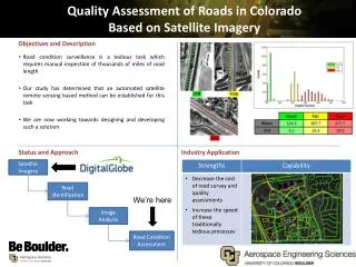
Quality Assessment of Roads in Colorado Based on Satellite Imagery. April 7, 2014. Algorithm Overview. Satellite Imagery. Road Identification. Image Analysis. Road Condition Assessment. Pan-Sharpening. What we have High resolution panchromatic imagery (B/W)

E N D
Quality Assessment of Roads in Colorado Based on Satellite Imagery April 7, 2014
Algorithm Overview Satellite Imagery Road Identification Image Analysis Road Condition Assessment
Pan-Sharpening • What we have • High resolution panchromatic imagery (B/W) • Low resolution multispectral imagery (Color) • We create high resolution color images (Pan-sharpening) • Helps in retaining 8 bands of information at high resolution • Will help automatically identify asphalt better
Road Identification • Next we perform machine learning based classification • To increase infallibility of automatic extraction of asphalt pixels Training Data Asphalt Pixels Classifier Satellite Imagery
Image Analysis • Highway pavement becomes lighter in panchromatic grayscale shade as it degrades • Digital number increases • Mean increases • Highway pavement becomes less uniform as it degrades • Data range increases • Variance increases • Entropy increases • These changes are detectable through texture filtering of satellite imagery • Can likely be used to classify road surface conditions such as good, fair, poor and to justify repaving needs
Asphalt Degradation Spectral Characteristics of Aging Asphalt (Herold, 2007)
Digital Number 21B 115A 24A Highways in Colorado Springs
Variance 21B 115A 24A Highways in Colorado Springs
Result Comparison and Verification • CDOT and PPACG perform in situ road surveillance at specific regions of interest • University of Colorado implements its remote sensing based road condition assessment scheme on same regions • Compare the results and quantify the degree of agreement
Conclusion • A technically detailed scheme is in place • Project moving ahead on schedule • May supplement or replace current techniques • Investment towards faster and easiersurveillance