Download
1 / 22
220 likes | 376 Views
Meteorological Services and Weather Maps. PO 405.14. FORECASTED UPPER WINDS AND TEMPERATURES - (FDCN). • FD are forecasts of Wind and Temperature aloft for various altitudes (ASL). They are prepared to meet aviation requirements for flight planning;

E N D
Meteorological Services and Weather Maps PO 405.14
FORECASTED UPPER WINDS AND TEMPERATURES - (FDCN) • FD are forecasts of Wind and Temperature aloft for various altitudes (ASL). They are prepared to meet aviation requirements for flight planning; • FD forecasts are generated automatically twice a day. • FD bulletins are amended (if necessary) 4 times a day based on upper air analysis of 00, 06, 12 and 18Z; and • Issue time and the validity period is indicated in the body of the forecast Example follows: FDCN01 CWAO 180320Z FCST BASED ON 180000 DATA VALID 180600 FOR USE 05-09
UPPER WINDS AND TEMPERATURES (FDCN) FDs are produced for over 140 sites across Canada. The Flight Levels available are: Low Level - FL030, FL060, FL090, FL120 AND FL180 They follow the format ddfftt, where: - dd - is the Wind Direction (true) to the nearest 10°; - ff - is the Wind speed (in knots); and - tt - is the temperature (in degrees Celsius) Example: 3000 6000 9000 12000 18000 YVR 2707 2910+02 2809-04 2918-08 2934-18 Note: for info only : a High Level FD is also issued for FL240 and above.
FDCN01 CWAO 211520FCST BASED ON 211200 DATA VALID 211800 FOR USE 17-21 3000 6000 9000 12000 18000YVR 3108 9900+14 9900+06 9900+00 3416-12YYF 9900 3607+14 3411+06 3412-02 3516-13YXC 9900+13 1007+05 9900-02 9900-15YYC 1712+11 2105+04 2708-03 9900-15YQL 1205+10 1905+05 2307-02 2415-14YEA 9900+10 9900+03 2806-02 2710-14
• the 3,000 ft level wind is omitted when the terrain elevation (station elevation) is greater than 1500ft i.e. Edmonton CYEG (station Elevation 2273 ft ASL); • temperatures are not forecasted for the 3,000 ft level; • the code 9900 is used to indicate light and variable winds or wind speeds of less than 5 knots • wind speeds over 100 kts are coded by adding 50 to the direction and subtracting 100 from the speed. i.e. 240° at 130 kts is coded as 7430; and UPPER WINDS AND TEMPERATURES(FDCN)
FDCN01 CWAO 181520Z FCST BASED ON 181200 DATA VALID 181800 FOR USE 17-21 3000 6000 9000 12000 18000 YVR 9900 3007+01 2809-04 2918-07 2943-17 YYF 9900 2911+04 2913-03 2409-08 2817-19 YYC 9900+08 3105+00 3213-07 2912-19 YEG 3040+08 3055-06 3185-16 8301-34 Notes: YVR at 3000 ft - wind shows 9900 - which means winds are light and variable or wind speeds less than 5 knots YYC at 9000 ft - wind shows 3213+00 = 320° at 13kt temp 0°C YEG at 18000 ft Example for Between 21-06 at 9000ft the winds are 340 degrees true at 18 knots with a temperature of minus 08° C UPPER WINDS AND TEMPERATURES
SIGMETS (WSCN) – SIGNIFICANT MET ADVISORIES • the SIGMET is a short-term weather warnings to aircraft in-flight of severe and hazardous weather conditions that have occurred or are expected to occur • the SIGMET amends a Graphic Area Forecast (GFA) and are broadcast immediately upon receipt on the navigational aids voice channels • these weather conditions could include: • - severe turbulence / severe icing; • - thunderstorms / moderate or heavy hail; • - squall lines / low level wind shear/ mountain waves • - tornadoes, water spouts or hurricanes • - volcanic ash / wide spread dust or sand storms.
SIGNIFICANT MET ADVISORIES SIGMETS (WSCN) Example WSCN32 CWEG 161520 SIGMET A1 VALID 161520/161730 CWEG – WTN 20 NM OF A LN EXTNG FM 5104N O9507W /50 W RED LAKE – 5008N 0965W /20NE WINNIPEG. BKN LN TS OBSD ON RDR AND LTNG DTCTR. CB TOPS 380 MAX TOPS 440. LN MOVG EWD 20 KT. END
-prior to flying, pilots are encouraged to obtain an weather briefing and all pertinent NOTAM from the Flight Information Centre (FIC) in their region - the phone number is 1-866-WX-BRIEF (992-7433) -calls to this number are routed to the FIC that serves the area from where the call originates - FICs are especially equipped to provide the weather information to pilots both at the pre-flight and the in-flight stages. Services that are specific to an aerodrome – such as airport advisory and local weather observations will continue to be provided locally through the NAV CAN Flight Service Station (FSS) Aviation Weather Briefing Service (AWBS)
-to provide a means of mass dissemination of aviation weather information, recorded weather data is continuously broadcast on the primary low frequency Navaid (NDB) -the TWBs are also available on multiple access telephone lines as listed in the Canada Flight Supplement book -The broadcast data includes: -flight precautions - weather synopses - significant en route -weather reports -upper winds -selected pilot - radar reports -hourly & special weather reports - terminal forecasts -selected NOTAMS Transcribed Weather Broadcasts (TWB)
Aviation Weather Web Site (AWWS) • www.flightplanning.navcanada.ca • Excellent resource for weather information • Satellite, radar, forecasts, charts etc • Pilots Automatic Telephone Weather Answering Service (PATWAS) • telephone service via FIC phone # then by pressing 3 on main menu • provides continuous readings of current conditions • Only in select locations, consult Canadian Flight Supplement • contain actuals/forecasts, icing conditions, winds/temps aloft, and select PIREPS.
Operates similar to PATWAS Continuous readings of conditions at a location Accessible by VHF frequency Assigned different phonetic identifiers at different times i.e. information “Bravo” may occur at 1900Z and information “Charlie” may occur at 2000Z Automatic Terminal Information System(ATIS)
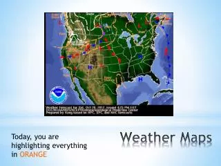
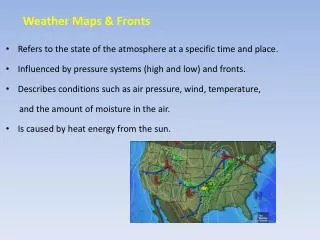
Canadian weather charts are prepared on a regular schedule by the Atmospheric Environmental Service and often used by meteorologists and briefers to give weather briefings Weather Maps and Prognostic Charts
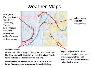
For Canada and USA issued 4 times a day at 6hour intervals 0000Z, 0600Z, 1200Z and 1800Z Marked on map are isobars, high and low pressure areas/centre pressure values, and fronts Surface pressure patterns are representative up to 3,000 ft Reporting Stations Weather is plotted around the station in a standard pattern called a Station Model Surface Weather Maps and Satellite Imagery
Confirmation Stage