Download
1 / 16
160 likes | 267 Views
A Global Unmanned Aircraft System (UAS) Observational Network. Nikki Priv é August 16 2006. Nikki Priv é August 16 2006. Purpose. Improve observations in data poor regions Polar regions Southern hemisphere Oceans Provide consistent vertical profiles

E N D
A Global Unmanned Aircraft System (UAS) Observational Network Nikki Privé August 16 2006 Nikki Privé August 16 2006
Purpose • Improve observations in data poor regions • Polar regions • Southern hemisphere • Oceans • Provide consistent vertical profiles • high resolution and accuracy for climate studies • long term observations to detect trends • Eulerian observations on a grid • Improve operational forecasting • Satellite verification
Complementary observations to existing ground and satellite network. Combine UAS observations with satellite, buoy, and surface data for improved analyses. Satellites provide broad coverage, UAS would provide in situ observations and high resolution vertical profiles to expand the usefulness of the data.
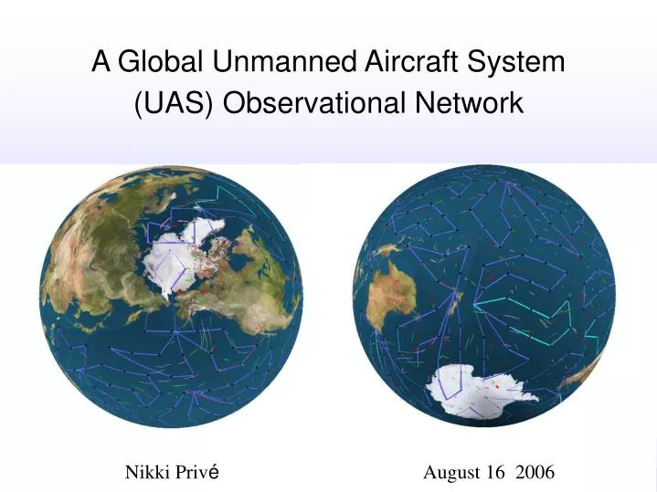
Proposed UAS Network • 36 High Altitude UAS (such as Global Hawk) • 30+ hr/14,000 miles • flies at 50-65,000 ft, above weather and commercial airspace • payload 1960 lbs • 12 base stations around the globe • 3 UAS stationed at each base • 244 fixed observational points • each point visited once every three days • on icosahedral grid over oceans and poles • buoys colocated at oceanic points • Adaptive observations between points as desired
Each observational point sampled every third day • Accurately determine atmospheric trends • Each UAS assigned a particular route
Viability of UAS Network • Goal: 97% reliability • Most points easily reached on schedule (100%) • Use ECMWF reanalysis wind fields to calculate flight times and statistics • Handful of points near southern hemisphere jet stream were sometimes difficult to reach on scheduled due to strong headwinds • Usually less than 5 minute delay • On-schedule drops possible >98% of the time
Base Stations • Located in friendly countries with proximity to target region • Takeoff criteria for Global Hawk • crosswind maximum: 10 kt • headwind maximum: 30 kt • no icing • presume UAS will fly around nearby icing conditions • no standing water on runway • visibility: assume 500 m minimum
Base Stations • Dataset: Integrated Surface Hourly data set TD3505 from the National Climatic Data Center • Crosswinds and icing the most stringent parameters for takeoff • Suitable airports hard to find in southern hemisphere midlatitudes and Arctic • strong winds • few major airports with multiple runways • Islands in tropical Pacific have only basic airport facilities and few available surface observations
Port Elizabeth, South Africa Aitutaki, Cook Islands Yap, Micronesia Diego Garcia, B.I.O.T. Seymour, Galapagos Praia, Cape Verde Hokitika, NZ Viable Base Stations • Lihue Airpot, Hawaii • Inverness, UK • Elmendorf AFB, Alaska (Anchorage) • Puntas Arenas, Chile • Invercargill, NZ • Geraldton, Australia • Nadi, Fiji
Instrumentation Suite - Sondes • Dropsondes • high vertical resolution • high accuracy observation of temperature (0.1ºC), humidity for climate observations • develop new lightweight sondes to meet goals • inexpensive “weather” sondes dropped between observational points • Sidesondes • Sondes which fall to a set pressure level and drift for several days • Significant instrument development needed • Multiple sondes dropped at each observational point • Adaptive observations for operational forecasting
Instrumentation Suite – In Situ • Instrument packages can be swapped as needed • Routine measurements • Ozone, water vapor, CO, CO2 • CCN and ice particles • Intensive observing flights • Chemical species • Cloud water and droplets • Aerosol composition
Remote sensors • Large payload on high-altitude UAS (1000 kg on Global Hawk) • Radiometers, lidar, scatterometers, radars, infrared spectrometers all viable • Select instrument package which will give new data and not just duplicate existing satellite observations • Stronger signal than satellites due to lower altitude • Higher resolution (but smaller coverage area) than satellites
Future Work • Observing System Simulation Experiment to determine benefits for operational forecasting • Development of sonde and instrumentation technology with integration onto UAS platforms • Single base as a “test” of UAS observing concept to work out the kinks and push instrumentation development