Download
1 / 51
520 likes | 745 Views
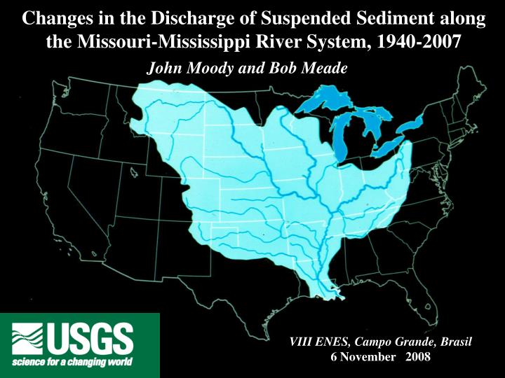
Changes in the Discharge of Suspended Sediment along the Missouri-Mississippi River System, 1940-2007. John Moody and Bob Meade. VIII ENES, Campo Grande, Brasil 6 November 2008. Introduction. John Moody. Bob Meade. Motivation: New Orleans after Hurricane Katrina.

E N D
Changes in the Discharge of Suspended Sediment along the Missouri-Mississippi River System, 1940-2007 John Moody and Bob Meade VIII ENES, Campo Grande, Brasil 6 November 2008
Introduction John Moody Bob Meade
Motivation: New Orleans after Hurricane Katrina Photos: Smiley N. Pool and Michael Amsworth, WWLTV
Remember that sediment deposition can be good Because deposition constructs barrier islands and wetlands that are protection for New Orleans
Some Candeleur islands before Katrina Two days after Katrina
Summary of talk • Virtual tour • Landscapes along the Missouri and Mississippi • Engineering activities along the Missouri and Mississippi River System • The mystery of the missing sediment
Great Falls of the Missouri River River Black Eagle Horseshoe Rainbow Montana Note: water has little sediment
Missouri Breaks Montana Note: water has little sediment Photo by Bob Lindholm Airphoto-Jim Wark
Missouri Breaks Montana Note: water has little sediment McClelland Ferry
Montana Fort Peck Dam View: upriver
Rio Missouri Rio Milk Montana Confluence below Fork Peck Dam Note: water of the Missouri River has little sediment Vista: abaixo Airphoto-Jim Wark
South Dakota Meade 2002 Reservoir Francis Case Upriver from Fort RandallDam in South Dakota
South Dakota Fort Randall Dam on Missouri River
South Dakota Yankton Gavins Point Dam on Missouri River Free-flowing Missouri River begins here
Nebraska Yankton View: downriver from Gavins Point Dam 1.8 million t/a
Nebraska Omaha Rio Missouri Bodmer Moody Loess bluffs 1833 Omaha, Nebraska 2002 Eppley Airport
Nebraska Omaha 26 million t/a Missouri River in Omaha, Nebraska
Nebraska Kansas Pile Dikes Indian Cave Bend View: downriver
Channelization of Missouri River Water -49% -99% -41% Channels Islands Reduced source of sediment and increased storage in new floodplains Adapted from Funk and Robinson, 1974
Kansas Missouri Confluence of the Osage and Missouri View: Upriver Airphoto-Jim Wark
Missouri Storage of sediment behind dikes MissouriRiver at Mile 189 View: Downriver Photo: R. Stallard
Hermann Missouri 88 million t/a Missouri River at Hermann, Missouri View: Upriver
Increase in suspended sediment discharge principle from loess landscape in Iowa Iowa Missouri Confluence of the Missouri and Nishnabotna Rivers Missouri 0 50 milhão t/a Yankton Hermann Iowa ~ 60 million t/a Total = 88 million t/a Adapted from Parker, 1988, IAHS Pub. 174
Missouri Wing Dams or Rock Dikes L-Dikes View: below Hermann and upriver 400 m
Missouri Sand dredging in the Missouri River near St. Louis, Missouri
Illinois Illinois St. Louis St. Louis Missouri Missouri 97 million t/a Mississippi in St. Louis, Missouri View: from the left bank
Illinois Missouri MississippiRiver at Cape Girardeau, Missouri View: Upriver Bank revetment
Illinois Missouri Mississippi River Upper Mile 51.0 L-Head dike
Illinois Missouri Mississippi River Upper Mile 37 Alternate dikes
Illinois Missouri Mississippi at Thebes, Illinois View: downriver The end of rocky outcrops along the banks
Confluence of the Ohio and Mississippi Rivers Kentucky Missouri Tennessee 800 m View: downrivier Mississippi Ohio
Bank protection and trapping of the sediment MississippiRiver at Mile 388 Vegetation mat with rock protection at the toe of the bank Articulated concrete mat
Mississippi River Red River Hydropower dam Arkan-sas Low-sill Louis-iana Auxiliary control Old River Outflow Channel Knox Landing Navigation Lock Tarbert Landing Simmesport Atchafalaya River Mississippi River
Arkan- sas Louis-iana Velocity, m s-1 190 million t/a 0 1.0 2.0 0 Profundidade, m 10 Q = 21,000 m3 s-1 20 0 200 400 600 800 1000 Lagura, m Mississippi River at Tarbert Landing, Mississippi
Flux of water and suspended sediment from the Mississippi River Catchment about 1980 Missouri Ohio Missouri Ohio
Louis-iana Louis-iana Mississippi River flowing through New Orleans Lake Pontchartrain
Louis-iana Mouth of the Mississippi River Gulf of México
Integrated bag sampler The mystery of the missing suspended sediment at Tarbert Landing
Significant decline after 1800 cerca de 1800 about 1800 cerca de 1980 about 1980 cerca de 1980 cerca de 1800 0 200 400 Suspended sediment discharge, million t/a
Mississippi River at Tarbert Landing Sediment Water ~ 370 million t/a Sediment Million t/a 190 130 Water km3 / a Water year in northern hemisphere (October through September)
One cause: Effect of dams closed ~ 150 million t/a 300 200 110 million t/a Missouri River 40 million t/a 100 Canada USA 0 1940 1950 1960 Fort Randall Dam Gavins Point Dam Yankton Amount entering between Omaha and Hermann Omaha Hermann Ohio River Milhões t/a Mississippi River N Tarbert Landing 500 0 kilometers Gulf of Mexico Water year in the northern hemisphere
Tarbert Landing Hermann Omaha Yankton Sediment Water 0 50 million t/a = Amount entering between Omaha and Hermann Sediment Milhões t/a Omaha Hermann Water Adapted from Parker, 1988, IAHS Pub. 174 km3 / a Water year in the northern hemisphere
Bank protection Cumulative protection of the bank or cumulative construction of dikes, kilometers dikes Annual suspended-sediment discharge, million metric tons year Other causes ~ 150 million t/a ~ ??? million t/a
~ 150 million t/a ~ ??? million t/a ~ ??? million t/a Other causes Area, ha USDA Photo: Tim McCabe Soil conservation Many small reservation in catchment of the Missouri River
~ 150 million t/a ~ ??? million t/a 1950-1966 ~ ??? million t/a Transport-limited system 1967- 2007 C Mean annual concentration of suspended sediment, mg / L Supply-limited system Q, Water discharge, km3 / a Effect: Change in the C-Q relation Tarbert Landing
Our Conclusions and Thoughts • Some of the missing sediment is behind the large dams. • Structures like dikes and “wing dams”, designed to protect banks store sediment and prevent erosion of the sediment. • Soil conservation probable has bee effective in reducing the sediment discharge to the Missouri-Mississippi River system. 4. The Missouri-Mississippi system has changed from transport limited system to a supply-limited system.
Our Conclusions and Thoughts 5. Sediment deposition can be a problem and sediment deposition can be beneficial depending upon the human assessment of the situation.. 6. We need to continue to collect good data on sediment discharge. Good data lives forever and are fundament to modeling sediment transport. Models should only be used to synthesize the data. In the world of “non-stationary”, continuity of data is critical.
Our Conclusions and Thoughts • The scientific paper in press on this subject could not have been possible without data collected over a long period of time (decades) • 8.We need to understand river ecosystems completely and not only in terms of engineering structures.
Our Conclusions and Thoughts 9. “Lean by listening and observing the river—each river is different.”.