Download
1 / 19
200 likes | 326 Views
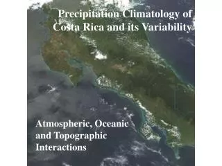
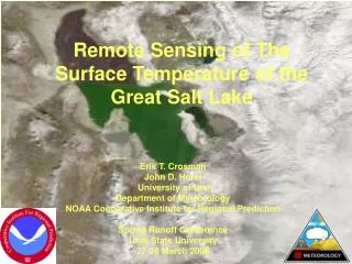
Climatology and Variability of Satellite-derived Temperature of the Great Salt Lake. Erik T. Crosman John D. Horel University of Utah NOAA Cooperative Institute for Regional Prediction. Why Study the Temperature of the Great Salt Lake?.

E N D
Climatology and Variability of Satellite-derived Temperature of the Great Salt Lake Erik T. Crosman John D. Horel University of Utah NOAA Cooperative Institute for Regional Prediction ASLO 2005 Aquatic Sciences Meeting
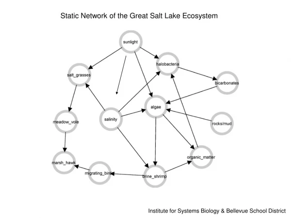
Why Study the Temperature of the Great Salt Lake? • Scientific research related to the impacts of changes in the physical state of the GSL has increased in recent years (Gwynn 2002) • Lake level, areal extent, salinity and surface temperature respond to regional climate variations
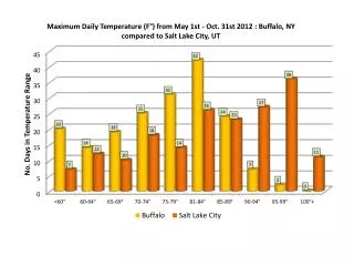
A Shrinking Impact? 2001 2003
Why Study the Temperature of the Great Salt Lake? Lake temperature has been examined for selected case studies and short field programs based on in situ and remote observations (Baskin 1998; Zastrow and Ridd 2002; Rich 2002) The contrast in temperature between the surface of the Great Salt Lake and surrounding land surfaces combined with the areal extent of the Lake affects local weather and climate (lake breezes, lake-effect snowstorms, etc.) Zumpfe and Horel 2005 Year to year variability of strong lake breeze fronts
Why Study the Temperature of the Great Salt Lake? • Hypothesis: Variability in lake areal extent and temperature on daily to interannual time scales leads to variations in local weather and climate • Goal- Document the spatial and temporal variations of lake surface temperature in order to assess: • the sensitivity of the lake to regional climate forcing • The sensitivity of local weather and climate to changes in lake surface temperature • Method- Use satellite data to document spatial and temporal variations in lake surface temperature 1981-present
Methodology • Advanced Very High Resolution Radiometer (AVHRR) images from 5 spectral channels at 1.1 km resolution from NOAA polar orbiting satellites 1981-present • Three visible channels used for daytime cloud identification and two infrared channels used for cloud identification and temperature • Infrared data calibrated and converted to brightness temperature • Split-window techniques used to correct for the effects of atmospheric water vapor • Lake temperature retrievals measure “skin” temperature of infinitesimally thin surface layer • Accuracy of AVHRR sea surface temperature retrievals approximately +/- 0.5 oC based on comparison to ocean buoys
AVHRR Imagery: Channel 1 .63 Microns (visible) Photo: J. Horel
AVHRR Imagery: Channel 4 10.3-11.3 Microns (thermal infrared)
AVHRR Imagery: Channel 5 11.5-12.5 Microns (thermal infrared)
Cloud Masking Procedure • Based on CLAVR-1 and CLAVR-x cloud detection, designed to detect clouds in AVHRR data • Cloud masks based on differences between cloud and lake reflectance and infrared emission • Uniformity tests too restrictive, not applied to the Great Salt Lake ASLO 2005 Aquatic Sciences Meeting
Example of Cloud Masking Upper left: Visible satellite image Upper right: Infrared channel difference test Lower right: Reflectance ratio test
Cloud Masked Lake Temperature Channel 4 Brightness Temperature Cloud Masked Lake Surface Temperature
Error Sources in Lake Surface Temperature Estimation: Error Source: Error Value: • Radiometer sensitivity0.05-0.12 oK • Absolute calibration of radiometer 0.3 oK • Uncertainty after cloud removal 0.5 oK • Foam unknown • Salinity negligible • Water vapor attenuation compensated for using split-window technique • Aerosol attenuation compensated for using algorithm coefficients • Skin temperature measurements may be significantly different than subsurface temperature when the lake is thermally stratified • Variations in satellite orbital path affect accuracy of image registration that can be compensated for ASLO 2005 Aquatic Sciences Meeting
Satellite-derived and in situ measurements Initial validation shows general agreement (+/- 1-2 oC) between post-processed 4-km satellite temperature retrievals and available in situ data Seasonality of diurnal signal related to thermal stratification? South arm temperature cycle at various depths (J.W. Gwynn, Utah Geological Survey) Satellite-derived annual temperature cycle 1981-2004 ASLO 2005 Aquatic Sciences Meeting
Future Work -- Lake temperature variability on time scales ranging from days to years -- Create a 25-year high-resolution climatology of lake temperature -- Climate signal? -- Relationship to lake depth? -- Examine and compare to MODIS data April 14th 2002 2057 UTC April 17th 2002 0901 UTC
Current and past lake temperature data www.met.utah.edu/research/saltlake ASLO 2005 Aquatic Sciences Meeting