Download

1 / 65
650 likes | 780 Views
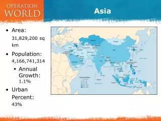
ASIA. Location (Physical Features & Countries) FSMS Standard SS7G9.a Days 1-3. ASIA GEOGRAPHIC UNDERSTANDINGS. SS7G9 – The student will locate selected features in Southern and Eastern Asia.

E N D
ASIA Location (Physical Features & Countries) FSMS Standard SS7G9.a Days 1-3
ASIAGEOGRAPHIC UNDERSTANDINGS • SS7G9 – The student will locate selected features in Southern and Eastern Asia. a. Locate on a world and regional political-physical map: Ganges River, Huang He (Yellow River), Indus River, Mekong River, Yangtze (Chang Jiang) River, Bay of Bengal, Indian Ocean, Sea of Japan, South China Sea, Yellow Sea, Gobi Desert, Taklimakan Desert, Himalayan Mountains, and Korean Peninsula
FIRST FIVE Agenda Message: Today we start our study of Southern and Eastern Asia. Before school tutoring is Tuesday starting at 7:30a. Standard: Locate selected features in Southern & Eastern Asia including rivers, mountains, Seas, Deserts, Oceans, Bays and the Korean Peninsula. Essential Question for Wednesday 11/6/13: What are the major geographic features in Southern & Eastern Asia? Warm Up for Wednesday 11/6/13: Name three things that you know about Asia. TODAY WE WILL: • Introduce the map of Southern & Eastern Asia
Answers E.Q. Answer for Monday November 4th: Ganges River Yellow Sea Indus River Indian Ocean Huang He (Yellow River) Sea of Japan Mekong River Gobi Desert Yangtze River Taklimakan Desert Himalayan Mountains South China Sea Bay of Bengal Tibetan Plateau Korean Peninsula Warm-Up Answer:
Before you begin terms to know • Bay • Sea • Ocean • Typhoon • Monsoon • River peninsula
Vocabulary WordsCopy on frayer model Tributary – Any smaller stream or river that flows into a larger stream or river. Aquifers – Underground, water-bearing layers of rock, sand, or gravel. Acid rain – A type of polluted rain, produced when pollution from smokestacks combines with water vapor. Ozone layer – A form of oxygen in the atmosphere that helps protect Earth from harmful solar radiation. Global warming – A slow increase in Earth’s average temperature. Greenhouse effect – Process by which Earth’s atmosphere traps heat.
ASIAGEOGRAPHIC UNDERSTANDINGS Physical Geography Introduction The southern and eastern parts of Asia are home to almost half of the world’s population. The geography of this large area is varied, containing some of the world’s longest rivers, highest mountain ranges and large extensive deserts.
Over View http://app.discoveryeducation.com/search?Ntt=southeast+asia&N=4294949099 Land forms http://app.discoveryeducation.com/search?Ntt=southeast+asia&N=18342&N=4294949099
ASIAGEOGRAPHIC UNDERSTANDINGS The Indus River Indus River begins in the mountains of Tibet and flows almost 200 miles through the country of Pakistan before emptying into the Arabian Sea. The Indus River valley is one of the richest farming areas in this region. Many different civilizations have lived along this river throughout the centuries.
ASIAGEOGRAPHIC UNDERSTANDINGS Ganges River The Ganges River is India’s most important river. It begins in the Himalayan Mountains and flows southeast through India and Bangladesh before emptying into the Bay of Bengal. The water of the Ganges carries tons of rich sediment (topsoil, silt and minerals from the mountains) that is gradually spread along its path enriching the farmland and creating a large, fertile delta at the mouth of the river.
ASIAGEOGRAPHIC UNDERSTANDINGS Ganges River cont. Because so many people live and work along the Ganges, the water in the river is heavily polluted. The country of Bangladesh is located almost completely in the Ganges River delta. Monsoon Season Heavy flooding in this part of the world during the monsoon season (a seasonal prevailing wind, lasting several months, bringing heavy rains) often causes great hardships for those living in this country.
Water Pollution The Ganges http://www.compulsivetraveler.tv/videos/408-Ganges-River-Pollution http://www.reuters.com/news/video?videoId=166276235
ASIAGEOGRAPHIC UNDERSTANDINGS Indian Ocean Further out to sea is the Indian Ocean, which is the third largest ocean in the world. Mountains & Plateau The Himalayan Mountains form the southern border of China. This high ground spreads to the north to form the Tibetan Plateau.
ASIAGEOGRAPHIC UNDERSTANDINGS Mountains & Plateau cont. The area is sometimes called “the roof of the world” because of its high altitudes. This wide area of mountains and high plateau blocks any moisture coming from the rivers and seas to the south. The Himalayan Mountains form India’s eastern border with China and Nepal.
ASIAGEOGRAPHIC UNDERSTANDINGS Mountains & Plateau cont. These high mountains form a barrier between Indian and countries to her north and east. The Himalayan Mountains stretch for almost 200 miles. The highest mountain in the world, Mount Everest, is on the border between Nepal & China.
ASIAGEOGRAPHIC UNDERSTANDINGS Deserts As the mountains begin to level off in the north, the land becomes desert. Here one finds the Taklimakan Desert and the Gobi Desert. The Taklimakan Desert is over 600 miles in length, one of the longest deserts in the world.
ASIAGEOGRAPHIC UNDERSTANDINGS Deserts cont. To the west and in the central part of China is the Gobi Desert, which can be one of the “hottest” and also one of the “coldest” places in the world. Much of the Gobi Desert is covered with sand and rocks.
Rivers http://app.discoveryeducation.com/search?Ntt=southeast+asia&N=4294949099
ASIAGEOGRAPHIC UNDERSTANDINGS China’s River China’s fertile farming areas lay north and east of the Gobi desert region. The Huang He, or Yellow River, begins in the Tibetan Plateau. It flows toward the east and finally empties into the Yellow Sea.
ASIAGEOGRAPHIC UNDERSTANDINGS China’s Rivers cont. The yellow dust blowing out of the Gobi Desert is picked up by the Huang He and carried along as loess (another name for silt), giving both the river and the sea a yellowish color. The frequent flooding has led some to call the Yellow River “China’s Sorrow.”
FIRST FIVE Agenda Message: Map Review Quiz Wednesday November 20th, 2013 Standard: Locate on a world and regional political-physical map Pakistan, India, China, Japan, Indonesia, North Korea, South Korea, and Vietnam. E.Q.Friday 11/15/13: List the names of the seven countries we are responsible for in S&EA for this unit. Warm Up:Why is India sometime referred to as the subcontinent? TODAY WE WILL: • Complete Geography & Political highlights of S&EA including Maps
Answers E.Q. Answers for Friday November 8th: Pakistan IndiaVietnam South Korea North Korea Japan China Warm-Up Answers: Because India is such a large landmass that is part of the Asian continent, but is in many ways geographically separate from it.
SS7G9 – The student will locate selected features in Southern and Eastern Asia. a. Locate on a world and regional political-physical map: Ganges River, Huang He (Yellow River), Indus River, Mekong River, Yangtze (Chang Jiang) River, Bay of Bengal, Indian Ocean, Sea of Japan, South China Sea, Yellow Sea, Gobi Desert, Taklimakan Desert, Himalayan Mountains, and Korean Peninsula
ASIAGEOGRAPHIC UNDERSTANDINGS Mekong River Flowing through China, Myanmar (formerly known as Burma), Thailand, Laos, Cambodia, & Vietnam, the Mekong River affects the lives of over 60 million people, many of whom are the poorest in the world. One of the regions most important crops, rice is grown extensively in the Mekong River Basin.
Mekong River http://app.discoveryeducation.com/search?Ntt=south+east+asia
ASIAGEOGRAPHIC UNDERSTANDINGS Oceans, Bays, & Seas Indian Ocean The third largest of the world’s five oceans is the Indian Ocean. It’s Relative Location is between Africa to the west, Asia to the north, Australia to the east, and the Southern Ocean to the south.
ASIAGEOGRAPHIC UNDERSTANDINGS Bay of Bengal The Bay of Bengal is an arm of the Indian Ocean with India to the west and Myanmar to its east. The Ganges River flows into the bay. Sea of Japan The Sea of Japan is an arm of the Pacific Ocean that lies between the Asian continent and Japan.
Bay of Bengal
ASIAGEOGRAPHIC UNDERSTANDINGS South China Sea The South China Sea lies between Vietnam and the Philippines. Weather in the region is marked by violent monsoons and typhoons. Yellow Sea This arm of the Pacific Ocean lies between China and Korea. It gets its name from the Yellow River which flows into the sea.