Download
1 / 20
210 likes | 339 Views
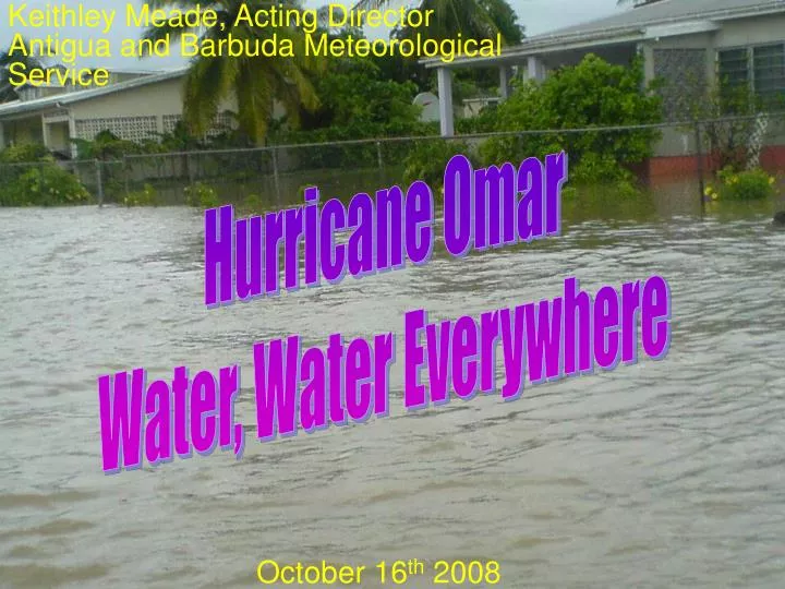
Keithley Meade, Acting Director Antigua and Barbuda Meteorological Service. Hurricane Omar Water, Water Everywhere. October 16 th 2008. FORMED FROM A TROPICAL WAVE ON 30 SEPTEMBER AND REACHED THE E.C ON 10 OCTOBER. SHOWER ACTIVITY SHOWED SIGNS OF ORGANIZATION ON 11 OCTOBER

E N D
Keithley Meade, Acting Director Antigua and Barbuda Meteorological Service Hurricane Omar Water, Water Everywhere October 16th 2008
FORMED FROM A TROPICAL WAVE ON 30 SEPTEMBER AND REACHED THE E.C ON 10 OCTOBER. • SHOWER ACTIVITY SHOWED SIGNS OF ORGANIZATION ON 11 OCTOBER • TD #13 FORMED ON 13 OCTOBER ABOUT 175 MILES NORTH-NORTHWEST OF CURACAO. • MOVED SLOWLY AND ERRATICALLY ON 13-14 OCTOBER AND BECAME A TS 14 OCTOBER ABOUT 125 MILES NORTH OF CURACAO. • TURNED NORTHEASTWARD AND ACCELERATED ON 15 OCTOBER. • BECAME A HURRICANE AND RAPIDLY STRENGTHENED TO A PEAK INTENSITY OF 125 MPH ON 16 AS IT PASSED THROUGH THE VIRGIN AND NORTHERN LEEWARD ISLANDS. • LATER THAT DAY, SOUTHWESTERLY VERTICAL WIND SHEAR CAUSED RAPID WEAKENING REDUCING IT TO A TROPICAL STORM EARLY ON 17TH OCTOBER. • A TEMPORARY DECREASE IN THE SHEAR ALLOWED IT TO REGAIN HURRICANE STRENGTH LATER THAT DAY.. HOWEVER...IT WEAKENED BACK TO A TROPICAL STORM THE NEXT DAY. • MOVEMENT OVER COLDER SEA SURFACE TEMPERATURES CAUSED OMAR TO DECAY TO A REMNANT LOW ON 18 OCTOBER ABOUT 820 MILES EAST OF BERMUDA. • MOVED SLOWLY NORTHEASTWARD AND DISSIPATED EARLY ON 21 OCTOBER ABOUT 650 MILES WEST OF THE WESTERN AZORES ISLANDS. SOURCE(NWS TPC/NATIONAL HURRICANE CENTER MIAMI FL)
V.C Bird Int’l Airport Courtesy of Barrimore Gore - Observer on Duty at the time
Omar ‘08 Lenny ‘99
Conclusions • The general public was well informed through radio and television appearances. • All bulletins were faxed and emailed to all concerned • Disaster management officials however on hearing only a storm, even though 5 to 10 inches of rainfall was stressed, did not prepare for flooding. • Shelters were left unopened until after the flooding had started. Emergency Operations were not activated. • There was an attempt to shift the blame to the Met Office for not pointing out that all that rain would have fallen in such a short time.
Lessons • Good general public awareness is not necessarily enough. • We must make a greater effort to ensure that Disaster management and other officials are fully cognizant of the gravity of the threat. • Must stress that even though winds are not expected to be damaging, other factors could be just as devastating. • Must encourage public to prepare for the total effect of a hurricane.
A wet night’s work! Thank You!!