Download
1 / 33
380 likes | 722 Views
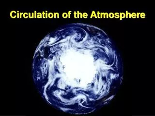
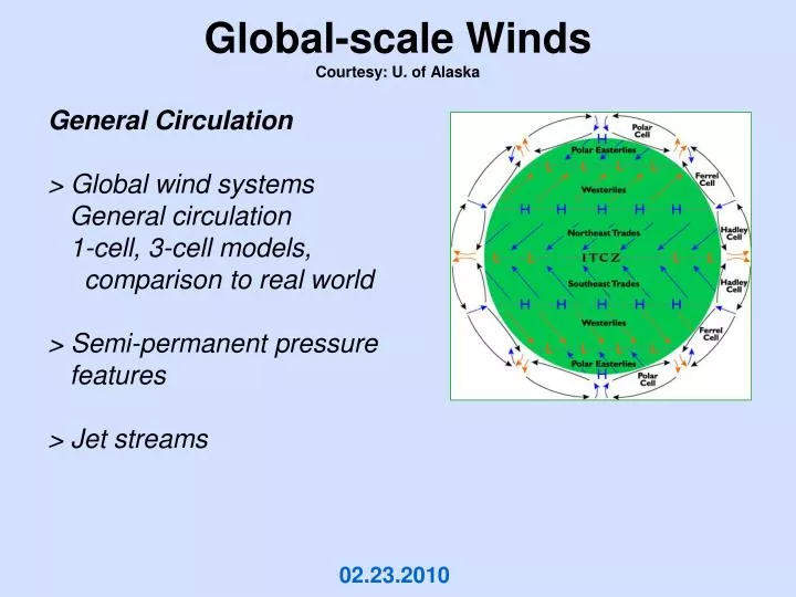
Global-scale Winds Courtesy: U. of Alaska. General Circulation > Global wind systems General circulation 1-cell, 3-cell models, comparison to real world > Semi-permanent pressure features > Jet streams. 02.23.2010. Scales of Motion - Hierarchy. Longwaves. planetary scale.

E N D
Global-scale WindsCourtesy: U. of Alaska General Circulation> Global wind systems General circulation 1-cell, 3-cell models, comparison to real world> Semi-permanent pressure features> Jet streams 02.23.2010
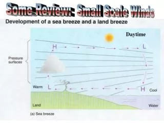
Scales of Motion - Hierarchy Longwaves planetaryscale Weather MapHighs and Lows Weather fronts synopticscale HurricanesTopical storms Land/sea breezeMtn/Valley breezeChinookSanta Ana ThunderstormsTornadoesWaterspoutsDust devils mesoscale Small turbulenteddies microscale secondstominutes minutestohours hourstodays daystoweeks
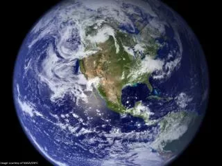
COLD UNEQUAL HEATINGOF THE EARTHTHERMAL IMBALANCE WARM COLD Atmospheric General Circulation + Large-scale, hemispheric flow + DRIVING FORCE??+ Average wind patterns across globe + Interrupted by highs and lowsmoving through
Net LOSS Net GAIN Net LOSS Energy Imbalance Driver of Atmospheric Circulation Atmospheric General Circulation UNEQUAL HEATING OF THE EARTH THERMAL IMBALANCE COLD WARM COLD
COLD WARM COLD Models of Atmospheric Circulation Single-cell ModelAssume1) aqua planet2) sun over equator 3) non-rotating earth
pressure high low Models of Atmospheric Circulation Single-cell ModelAssume1) aqua planet2) sun over equator 3) non-rotating earth Result>excessive heating at equator >thermally-driven convection cell >pole-ward flow aloft equator-ward flow sfc >termed, Hadley cell The Atmosphere, 8th edition, Lutgens and Tarbuck, 8th edition, 2001
Models of Atmospheric Circulation Three-cell ModelAssume1) aqua planet2) sun over equator 3) non-rotating earth Result>excessive heating at equator >thermally-driven convection cells >deflection of winds >Hadley cell Ferrel cell Polar cell The Atmosphere, 8th edition, Lutgens and Tarbuck, 8th edition, 2001
Atmospheric Circulation Models vs Reality Idealized winds Actual winds The Atmosphere, 8th edition, Lutgens and Tarbuck, 8th edition, 2001
Atmospheric Circulation Models vs Reality Why the difference? 1) land-water distribution 2) seasonality unequal heating/cooling rates Actual winds Idealized winds
Atmospheric Circulation Some Features of Note:Equatorial • ITCZ (Intertropical Convergence Zone) • Equatorial low • Area of low wind speed Doldrums (weak PG)
Atmospheric Circulation Some Features of Note:Subtropics • Trade winds • Horse latitudesweak winds • Subtropical highwarm and dryDesert areas of the world
Atmospheric Circulation Some Features of Note:Midlatitudes, Polar • Prevailing westerlies • Polar front and areas of low pressure • Polar easterlies
Persistent Circulation PatternsNHwinter Sea level pressure and prevailing winds
Persistent Circulation PatternsNHwinter > subtropical highs Sea level pressure and prevailing winds
Persistent Circulation PatternsNHwinter > 2 major subpolar lows: near polar front, storm track Sea level pressure and prevailing winds
Persistent Circulation PatternsNHwinter > subpolar highs: shallow, thermally induced Sea level pressure and prevailing winds
Persistent Circulation PatternsNHwinter > subpolar trough in SH: high winds and seas, roaring 40s Sea level pressure and prevailing winds
Persistent Circulation PatternsNHwinter > ITCZ displaced south Sea level pressure and prevailing winds
Persistent Circulation PatternsNHsummer > ITCZ displaced north Sea level pressure and prevailing winds
Persistent Circulation PatternsNHsummer > Subtropical highs move north Sea level pressure and prevailing winds
Persistent Circulation PatternsNHsummer > Thermal lows develop over land Sea level pressure and prevailing winds
Persistent Circulation PatternsNHsummer > Weak Icelandic Low remains, Aleutian Low disappears Sea level pressure and prevailing winds
Persistent Circulation PatternsNHsummer > Asian Monsoon season Sea level pressure and prevailing winds
summer Subpolar lows disappear Subtropical highs remain Zone of max heating shifts northWeak equator - pole temp gradient Seasonal Circulation Patterns winter Strong thermal imbalanceStrong pressure gradient Strong windsStrong equator - pole temp gradient Thermal Imbalance is the Driver Sea level pressure and prevailing winds
Seasonal Circulation Animation L H Sea level pressure and windsUniversity of Oregon Thermal Imbalance is the Driver
Dry Wet Wet Wet Wet Dry Dry Dry Dry Dry seasonally Dry Dry General Circulation and Precipitation Wet Wet Wet
General Circulation and Precipitation Dry Wet Precipitation (mm)University of Oregon
Jet Streams • Fast-moving rivers of air • High altitudes (~ 35000 ft) near tropopause • Long, shallow, narrow moving west to east • First observed during WW II • Suspected earlier from ground observations of fast-moving cirrus
Jet Streams • Mark boundary between surface air masses • Shows ridges, troughs, eddies • Changes in space and time
Jet Streams • Seasonality • Note the speeddifferences • Surface temperature differences • Tend to steer storm tracks