Download
1 / 1
10 likes | 136 Views
References. Takiguchi H., Y. Fukuda, J. Geod. Soc. Japan, 52, 2, 141-154, 2006a. Takiguchi H., T. Otsubo, Y. Fukuda, Earth, Planets and Space, 58, e13-e16, 2006b. G51C-0694. Development of the Estimation Service of the Earth‘s Surface Fluid Load Effects for Space Geodetic Techniques.

E N D
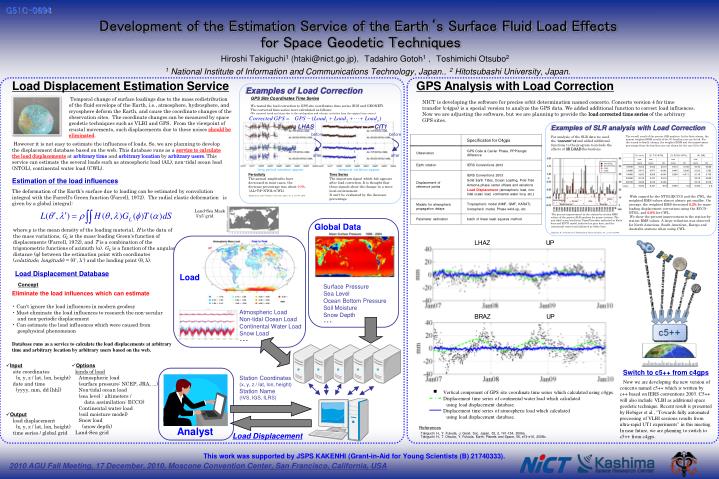
References Takiguchi H., Y. Fukuda, J. Geod. Soc. Japan, 52, 2, 141-154, 2006a. Takiguchi H., T. Otsubo, Y. Fukuda, Earth, Planets and Space, 58, e13-e16, 2006b. G51C-0694 Development of the Estimation Service of the Earth‘s Surface Fluid Load Effects for Space Geodetic Techniques Hiroshi Takiguchi1 (htaki@nict.go.jp), Tadahiro Gotoh1, Toshimichi Otsubo2 1 National Institute of Information and Communications Technology, Japan.,2 Hitotsubashi University, Japan. Load Displacement Estimation Service GPS Analysis with Load Correction Examples of Load Correction GPS Site Coordinates Time Series Temporal change of surface loadings due to the mass redistribution of the fluid envelope of the Earth, i.e., atmosphere, hydrosphere, and cryosphere deform the Earth, and cause the coordinate changes of the observation sites. The coordinate changes can be measured by space geodetic techniques such as VLBI and GPS. From the viewpoint of crustal movements, such displacements due to these noises should be eliminated. NICT is developing the software for precise orbit determination named concerto. Concerto version 4 for time transfer (c4gps) is a special version to analyze the GPS data. We added additional function to correct load influences. Now we are adjusting the software, but we are planning to provide the load corrected time series of the arbitrary GPS sites. We tested the load correction to GPS site coordinates time series (IGS and GEONET). The corrected time series were calculated as follows: (We removed trend and steps due to the earthquakes and volcanic activities from the original time series.) LHAS CIT1 Examples of SLR analysis with Load Correction before before For analysis of the SLR data we used the 'concerto' v4 and added additional functions to the program to include the effects of 3D LOAD fluctuations. The overall result of the precise SLR analysis. In the first column, the annual weighted RMS results of the (1) baseline case are listed. For the second to fourth column, the weighted RMS and the improvement percentage from the baseline case are shown for the case (2) to (4). However it is not easy to estimate the influences of loads. So, we are planning to develop the displacement database based on the web. This database runs as a service to calculate the load displacements at arbitrary time and arbitrary location by arbitrary users. This service can estimate the several loads such as atmospheric load (AL), non-tidal ocean load (NTOL), continental water load (CWL). after after long period variation appear temporal variation appear PeriodicityThe annual amplitudes have decreased in most cases, the decrease percentage was about 20%. (AL+T/P-NTOL+CWL) Time Series The important signal which hid appears after load correction. It is thought that these signals show the change in a more local environment. It can't be evaluated by the decrease percentage. Estimation of the load influences The deformation of the Earth’s surface due to loading can be estimated by convolution integral with the Farrell's Green function (Farrell, 1972). The radial elastic deformation is given by a global integral: With regard for the NTOL(ECCO) and the CWL, the weighted RMS values almost always get smaller. On average, the weighted RMS decreased 0.2% for mass-loading displacement corrections using the ECCO-NTOL, and 0.8% for CWL. We show the percent improvement in the station-by-station RMS values. A large reduction was observed for North American, South American, Europe and Australia stations when using CWL. Takiguchi, H., and Y. Fukuda, J. Geod. Soc. Japan,52, 2,141-154,2006. Land-Sea Mask 5’x5’ grid The percent improvement in the station-by-station RMS values of the precise SLR analysis for major stations. The non-tidal ocean load from Topex/Poseidon indicated as black bars and ECCO model indicated as gray bars, and the continental water load indicated as white bars. Global Data where ρ is the mean density of the loading material, H is the data of the mass variations, GL is the mass-loading Green's function of displacements (Farrell, 1972), and T is a combination of the trigonometric functions of azimuth (α). GL is a function of the angular distance (φ) between the estimation point with coordinates (colatitude, longitude) = (θ’, λ’) and the loading point (θ, λ). Takiguchi, H., T. Otsubo and Y. Fukuda Earth, Planets and Space, 58, 2, e13-e16, 2006. Load Displacement Database Load Concept Surface Pressure Sea Level Ocean Bottom Pressure Soil Moisture Snow Depth ・・・ Eliminate the load influences which can estimate • Can't ignore the load influences in modern geodesy • Must eliminate the load influences to research the non-secular and non-periodic displacement • Can estimate the load influences which were caused from geophysical phenomenon Atmospheric Load Non-tidal Ocean Load Continental Water Load Snow Load ・・・ Database runs as a service to calculate the load displacements at arbitrary time and arbitrary location by arbitrary users based on the web. • Input site coordinates (x, y, z / lat, lon, height) date and time (yyyy, mm, dd [hh]) • Options kinds of load Atmospheric load (surface pressure: NCEP, JRA, ...) Non-tidal ocean load (sea level : altimeters / data assimilation: ECCO) Continental water load (soil moisture model) Snow load (snow depth) Land-Sea grid Switch to c5++ from c4gps Station Coordinates (x, y, z / lat, lon, height) Station Name (IVS, IGS, ILRS) Now we are developing the new version of concerto named c5++ which is written by c++ based on IERS conventions 2003. C5++ will also include VLBI as additional space geodetic technique. Recent result is presented by Hobiger et al., "Towards fully automated processing of VLBI sessions results from ultra-rapid UT1 experiments" in this meeting. In near future, we are planning to switch to c5++ from c4gps. ・ Vertical component of GPS site coordinate time series which calculated using c4gps. Displacement time series of continental water load which calculated using load displacement database. Displacement time series of atmospheric load which calculated using load displacement database. • Output load displacement (x, y, z / lat, lon, height) time series / global grid Analyst Load Displacement This work was supported by JSPS KAKENHI (Grant-in-Aid for Young Scientists (B) 21740333). 2010 AGU Fall Meeting, 17 December, 2010, Moscone Convention Center, San Francisco, California, USA