Download
1 / 7
70 likes | 154 Views
Extended Glider Surveys of ITF Pathways. Impact

E N D
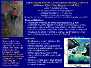
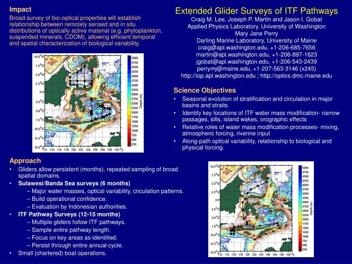
Extended Glider Surveys of ITF Pathways Impact Broad survey of bio-optical properties will establish relationship between remotely sensed and in situ distributions of optically active material(e.g. phytoplankton, suspended minerals, CDOM), allowing efficient temporal and spatial characterization of biological variability. Craig M. Lee, Joseph P. Martin and Jason I. Gobat Applied Physics Laboratory, University of Washington Mary Jane Perry Darling Marine Laboratory, University of Maine craig@apl.washington.edu, +1-206-685-7656 martin@apl.washington.edu, +1-206-897-1623 jgobat@apl.washington.edu, +1-206-543-2439 perrymj@maine.edu, +1-207-563-3146 (x245) http://iop.apl.washington.edu ; http://optics.dmc.maine.edu • Science Objectives • Seasonal evolution of stratification and circulation in major basins and straits. • Identify key locations of ITF water mass modification- narrow passages, sills, island wakes, orographic effects • Relative roles of water mass modification processes- mixing, atmospheric forcing, riverine input • Along-path optical variability, relationship to biological and physical forcing. • Approach • Gliders allow persistent (months), repeated sampling of broad spatial domains. • Sulawesi/Banda Sea surveys (6 months) • Major water masses, optical variability, circulation patterns. • Build operational confidence. • Evaluation by Indonesian authorities. • ITF Pathway Surveys (12-15 months) • Multiple gliders follow ITF pathways. • Sample entire pathway length. • Focus on key areas as identified. • Persist through entire annual cycle. • Small (chartered) boat operations.
Extended Glider Surveys of ITF Pathways Impact Broad survey of bio-optical properties will establish relationship between remotely sensed and in situ distributions of optically active material(e.g. phytoplankton, suspended minerals, CDOM), allowing efficient temporal and spatial characterization of biological variability. Craig M. Lee, Joseph P. Martin and Jason I. Gobat Applied Physics Laboratory, University of Washington Mary Jane Perry Darling Marine Laboratory, University of Maine craig@apl.washington.edu, +1-206-685-7656 martin@apl.washington.edu, +1-206-897-1623 jgobat@apl.washington.edu, +1-206-543-2439 perrymj@maine.edu, +1-207-563-3146 (x245) http://iop.apl.washington.edu ; http://optics.dmc.maine.edu • Science Objectives • Seasonal evolution of stratification and circulation in major basins and straits. • Identify key locations of ITF water mass modification- narrow passages, sills, island wakes, orographic effects • Relative roles of water mass modification processes- mixing, atmospheric forcing, riverine input • Optical variability, relationship to biological and physical forcing. Example section from Gulf of Alaska • Approach • Gliders allow persistent (months), repeated sampling of broad spatial domains. • Sulawesi/Banda Sea surveys (6 months) • Major water masses, optical variability, circulation patterns. • Build operational confidence. • Evaluation by Indonesian authorities. Assess possibilities for further glider-based observations. • Small (chartered) boat operations.
Seaglider and Sensors • Hull length: 1.8 m, Wing span: 1.0 m • Mass: 52 kg • Easy to deploy and recover • Surface to 1000 m. • Horizontal speed 0.1 - 0.45 m/s (~22 km or 12 nm per day @0.25 m/s) • Vertical speed 0.06 m/s (minimum) • Buoyancy range ~840 g • 5 kg/m3 density range ►250 g • Endurance depends on ambient stratification, dive depth and desired speed • Longest range to date: 3900 km • Longest endurance to date: 31 weeks • Navigation using GPS • Communications via Iridium satellite telephone • Call into base station located in Seattle- could also transmit to Indonesian base station • Sensors • SBE Conductivity/Temperature • SBE 43 Dissolved Oxygen • WETLABS BB2SF- Chlorophyll a Fluorescence, Optical Backscatter (red & blue) • RDI 1200 kHz ADCP- velocity • Inferred • Depth-Averaged Current • Surface Current • Vertical Current Profile (|w|>0.5 cm/s)
Yakutat Eddy Surveys • Remotely sensed SLA traces anticyclone to formation near Yakutat. • At given isopycnal, eddy waters warmer and more saline than ambient. • Eddy waters reach fresher extrema in surface layer. • Chl max at eddy edges.
Washington Coast • Glider & remotely sensed ocean color. • Vertical structure changes across eddy. Brandon Sackmann, UM