Download
1 / 23
270 likes | 954 Views
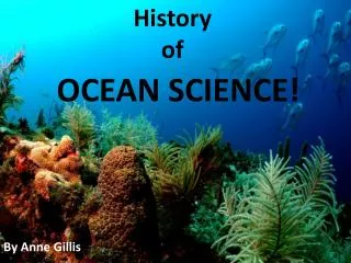
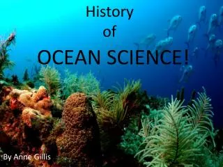
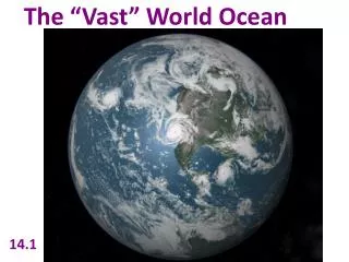
Earth Science 14.1 The Vast World Ocean. The Vast World Ocean. The Blue Planet. The World’s Oceans: Nearly 71% of the Earth’s surface is covered by ocean. Yet to this day we probably know more about the solar system than we do about what life exists at the very bottom of our oceans.

E N D
Earth Science 14.1 The Vast World Ocean The Vast World Ocean
The Blue Planet The World’s Oceans: • Nearly 71% of the Earth’s surface is covered by ocean. • Yet to this day we probably know more about the solar system than we do about what life exists at the very bottom of our oceans. • Not until the late 1800s did we even start to examine our oceans in detail and try to understand the complex web of life that can be found there.
The Blue Planet The World’s Oceans: • New technologies in recent years have allowed scientists to collect much data about the world’s oceans. • As technology has advanced, the field of oceanography has grown. • Oceanography, the study of the world’s oceans, is a science that draws on the methods and knowledge of geology, chemistry, physics, and biology to study all aspects of the world’s oceans.
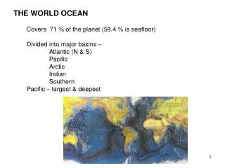
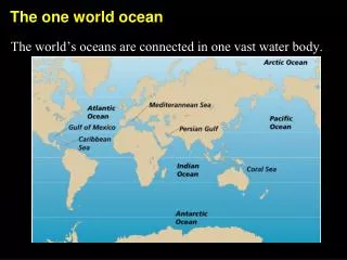
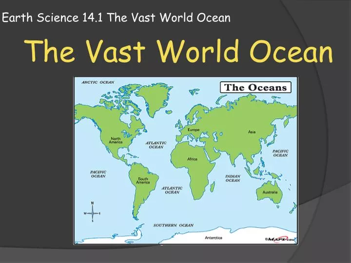
The Blue Planet The World’s Oceans: • The total area of the Earth’s surface is about 510 million square kilometers. • Of this, about 360 million square kilometers (71%) is covered with oceans or smaller seas such as the Mediterranean Sea. • The remaining Earth’ surface, 150 million square kilometers (29%) is covered by the continents and islands. • The world’s oceans can be divided into 4 main ocean basins: The Pacific Ocean, the Atlantic Ocean, the Indian ocean, and the Arctic ocean.
The Blue Planet The World’s Oceans: • The Pacific Ocean is the largest of Earth’s oceans. • It is the single largest geographical feature on the Earth’s surface. • It covers more than half the ocean surface on Earth. • It is also the world’s deepest ocean with an average depth of 3940 meters.
The Blue Planet The World’s Oceans: • The Atlantic Ocean is about half the size of the Pacific Ocean. • It is a relatively narrow ocean compared to the Pacific. • Both the Atlantic and Pacific are bounded to the east and west by continents.
The Blue Planet The World’s Oceans: • The Indian Ocean is slightly smaller than the Atlantic Ocean, but is about the same average depth. • Unlike the Atlantic and Pacific, the Indian ocean is located almost entirely in the southern hemisphere.
The Blue Planet The World’s Oceans: • The Arctic Ocean is about 7% of the size of the pacific ocean. • It is only a little more than one quarter as deep as the rest of the oceans.
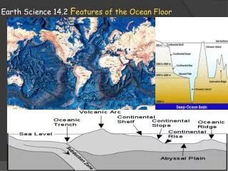
The Blue Planet Topography of the Oceans: • If all the water were drained from the ocean basins, a variety of features would be seen. • These features include chains of volcanoes, tall mountain ranges, deep ocean trenches, and large submarine plateaus. • The topography of the ocean floor is as diverse as that of the continents.
The Blue Planet Topography of the Oceans: • An understanding of ocean-floor features came with the development of techniques to measure the depth of the oceans. • Bathymetry is the measurement of ocean depths and the charting of the shape or topography of the ocean floor.
The Blue Planet Topography of the Oceans: • The first understanding of the ocean floors varied topography did not occur until the historic 3 and a half year voyage of the HMS Challenger. • From December 1872 to May 1876, the HMS Challenger expedition made the first, and perhaps most comprehensive, study of the global ocean ever attempted by a group. • Throughout the voyage, they measured water depth by lowering long weighted lines overboard. Today, scientists use modern techniques such as SONAR to accomplish the same tasks. Route of the HMS Challenger, it covered over 1000 days and 68,000 nautical miles
The Blue Planet SONAR: • In the 1920’s, a technological breakthrough occurred with the invention of sonar, a type of depth sounding equipment. • Sonar is an acronym for Sound Navigation And Ranging.
The Blue Planet SONAR: • Sonar, also referred to as echo sounding, works by transmitting sound waves towards the ocean bottom. • A receiver than detects the signals that bounce back from the ocean bottom and determines the depth by calculating the speed of sound waves in water (about 1500 meters per second) .
The Blue Planet SONAR: • The depths determined from continuous plotting of these signals allows scientists to plot the ocean floor to reveal features such as plateaus and mountain ranges. • In the last few decades, more complex systems using multi-beam sonar systems have developed. These multi-beam systems gather information on a strip of ocean floor rather than a single point by using multiple beams simultaneously. • By towing behind a ship, like mowing a lawn, oceanographers can build up a map of an area in a shorter time span.
The Blue Planet Satellite Measurement: • Measuring the shape of the ocean floor from space is another recent technological breakthrough that has led to a better understanding. • After compensating for waves, tides, currents, and atmospheric affects; scientists have discovered that the ocean surface is not perfectly flat. • This is because gravity attracts water toward regions where massive ocean floor features occur. • Therefore, mountain ranges and ridges produce elevated areas on the ocean’s surface that can be measured from space. Canyons and trenches cause slight depressions.
The Blue Planet Satellite Measurement: • The difference in ocean height is not visible to the naked eye however satellites are able to measure these small differences by bouncing microwaves off the ocean surface. • By knowing the satellite’s exact position through GPS, sea-surface height can be measured to a tolerance of 3 to 6 centimeters. • The data from these type of measurements can be used to build detailed ocean maps in a much faster amount of time.
The Blue Planet Submersibles: • Another way scientists learn about the ocean floor is by direct contact; going there in small submarines designed to handle the immense pressures of deep ocean waters. • A submersible is a small underwater craft used for deep-sea research.
The Blue Planet Submersibles: • Submersibles are used to collect data about areas of the ocean that were previously unreachable. • Submersibles are equipped with a number of instruments and recording devices to capture all types of information, from temperature and pressure gauges to video and audio recording tools.
The Blue Planet Submersibles: • The first submersible was used in 1934 by William Beebe. He descended to a depth of 923 meters off Bermuda in a steel sphere that was tethered to a mother ship. • In 1960, Jacques Piccard descended in the untethered submersible Trieste to 10,912 meters below the ocean surface into the Mariannas Trench.
The Blue Planet Submersibles: • Alvin and Sea Cliff II are two modern day manned submersibles used for deep sea research. • Alvin can reach a depth of 4000 meters and Sea Cliff II can reach 6000.
The Blue Planet Submersibles: • Today many submersibles are unmanned and operated remotely. The are call ROVs for remotely operated vehicles. • They collect data, record video, and have robot arms that can be used to dig, retrieve objects, and work underwater at great depths.
Computer Lab Assignment Use the internet to research and create a short mini-report on one of the following topics. • Sonar mapping of the ocean floor • Satellite mapping of the ocean floor • Submersibles and their use in exploration of deep ocean areas. • You must write at least 3 paragraphs or create 3 PowerPoint slides on your chosen topic. YOU MAY NOT CUT,COPY OR PASTE. PUT IT IN YOUR OWN WORDS