Download
1 / 3
30 likes | 170 Views
Applications of GOES-R Data to the Warn-on-Forecast Project. Thomas Jones September 15, 2011 GOES-R Science Week Meeting: Huntsville, AL. Warn-on-Forecast. Goals of the WoF Project Explore the use of current and future data sets to improve short-term (< 3 hour) forecasts

E N D
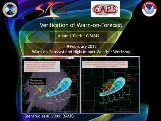
Applications of GOES-R Data to the Warn-on-Forecast Project Thomas Jones September 15, 2011 GOES-R Science Week Meeting: Huntsville, AL
Warn-on-Forecast • Goals of the WoF Project • Explore the use of current and future data sets to improve short-term (< 3 hour) forecasts • Assimilate these data into meso and storm-scale NWP models • Compare and contrast different datasets and assimilation techniques to determine those which prove most useful in a real-time, operational warning environment • Applications for satellite data in WoF data assimilation • Provide information on the near-storm environment • Provide information on the location and properties of clouds • These data can be used to deduce convective initiation and subsequent evolution of the convection • Assimilating this information into regional NWP models should lead to an improvement of short-term forecast of convective events.
Warn-on-Forecast • Current Projects: • Use hyperspectral sounder data (AIRS) To improve 0-3 hour forecasts of a severe weather event (May 10, 2010). • Temperature and dewpoint profiles improve mid-tropospheric characterization of the atmosphere • Increases forecast convection compared to not assimilating these data. • Future Projects: • Assimilate satellite derived cloud products • Examples include: • Cloud top pressure and temperature • Cloud coverage • Cloud liquid and ice water contents • All products to be retrieved from GOES-R ABI radiances • Testing of satellite-derived cloud products will utilize MODIS (and similar) data as will as OSSE experiments to prepare for GOES-R coming online in 2015-16. Increases forecast convection Better match to WSR-88D GOES Cloud Cover