Download
1 / 1
10 likes | 104 Views
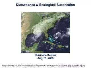
moat region without wave activity. Katrina Rita. no moat. Transient convective features collocated with high WN 2 activity, but no secondary wind maximum. Waves propagating around eyewall. Stagnation radius. Sustained WRV activity.

E N D
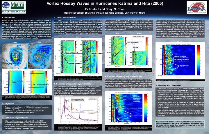
moat region without wave activity KatrinaRita no moat Transient convective features collocated with high WN 2 activity, but no secondary wind maximum Waves propagating around eyewall Stagnation radius Sustained WRV activity Fig. 5 same as in Fig. 4, except for Katrina with wavenumber 2 (contour). Radial propagation Inner model domain, 1.67 km resolution Fig. 4 Same as in in Fig. 2, except for Hurricane Rita (left panel). For a comparison, Katrina from Fig.2 is shown on the right. There is not wave propagation in the moat region in Rita, whereas Katrina shows regular wave activity outside of the primary eyewall without a moat. Fig. 2 Time-radius plot of wavenumber 2 from Katrina simulation on 28 Aug 2005. Left panel: PV (color) and vertical velocity (contour). Right panel: rain rate (color) and PV (contour). The line at ~80 km indicate the location of the stagnation radius. Monotonic velocity gradient Secondary wind maximum Fig.1 TRMM TMI/PR rainfall maps of Katrina and Rita (upper panels) and time-radial plot of azimuthally averaged wind speed at 700-mb level (lower panels). Horizontal lines indicate the three stages of the eyewall replacement cycle in Rita. Waves start propagating when moat disappears Contracting secondary wind and PV maximum Bridging band, wavenumber 1 Secondary rainband ring No wave activity Fig. 5 Fractional coverage of rainrate (color) overlaid with the wavenumber 1 component of rainrate (only positive contours - 5, 10, 15, 20 mm per hour are shown). Wave-rainband interaction does not start before 00 UTC on 22 Sep. Bridging bands are related to wavenumber 1 VRW propagating from the inner eyewall outward. Fig. 3 Azimuthally averaged wind speed (dashed) and PV (solid) in Rita at 3 different stages as indicated in Fig. 1. Collocated wind and PV maxima at respective times are denoted by solid and dashed arrows. Initially, the secondary maximum is rather broad but becomes more pronounced in the later two periods. Note that PV peaks are inside of the wind peaks corresponding to the strongest wind speed gradient. Vortex Rossby Waves in Hurricanes Katrina and Rita (2005) Falko Judt and Shuyi S. Chen Rosenstiel School of Marine and Atmospheric Science, University of Miami 4. Vortex Rossby Waves 1. Introduction Katrina and Rita were major hurricanes reached category 5 intensity in the Gulf of Mexico during the 2005 hurricane season. However, the two storms evolved differently. Rita developed concentric eyewalls and went through a complete eyewall replacement, whereas Katrina did not. Radar observations in hurricanes generally reveal inner spiraling rainbands emanating from the eyewall and propagating outward. Theoretical analysis indicated that these inner bands are radially propagating vortex Rossby waves (VRW). It has been hypothesized that the outward propagating VRW may play a role interacting with an existing secondary PV ring in the outer region of a hurricane, which could lead to a development of concentric eyewalls. VRWs are convectively coupled PV waves with vertical velocity leading PV by about one-quarter wavelength which distinguishes them from gravity waves. The time-radius diagrams in Fig. 2 reveal that waves propagate both azimuthally around the eyewall and radially outward in Katrina. A stagnation radius is found at ~80 km, beyond which no activity is observed. Within a region of <100 km from the storm center, VRW can interact with the mean vortex or other features. Wavenumber 1 and 2 are the most active waves. A comparison of VRW activity in Rita and Katrina is shown in Fig. 4. There is no wave propagation in the moat region in Rita. This result suggests that VRW from the primary eyewall did not play a role in the formation of the secondary eyewall in Rita at the early stage. In contrast, without a moat region, VRWs from the primary eyewall propagated outward in Katrina. Bridging bands are observed between the primary eyewall and the secondary ring of enhanced convection only after the start of the eyewall replacement on 22 September, which are related to the outward wavenumber 1 (Fig. 5). In contrast, the waves and bridging bands are active throughout the entire period in Katrina (Fig. 5). An enhanced, but transient convective region at ~50 km radius is not associated with a PV or wind maximum. This result doet not support the hypothesis of Montgomery and Kallenbach (1997) that the outward propagation of VRWs lead the development of the secondary PV and wind maxima near the stagnation radius. Rita Katrina Katrina Katrina 6. VRW and secondary ring of convection A ring of enhanced convection in Rita was observed early on 21 September, prior to the formation of the secondary wind maximum. To quantify the enhanced convection as a “ring”, we use the index developed by Ortt (2007) as the fractional coverage of grid points with rainrate > 12.5 mm per hour at any a given radius (Fig. 5). 5. Formation of secondary eyewall in Rita 7. Summary and Conclusion Rita developed a secondary wind maximum at ~125km away from the center (Fig. 1). It is collocated with a secondary ring of enhanced PV (Fig. 3). It contracts and eventually cause the primary eyewall to dissipate as Rita underwent an eyewall replacement cycle. Between the two wind maxima a region of suppressed convection (moat) is found. • VRW (with a radial wavelength of ~ 20 km) can be linked to inner-spiraling rainbands between the eyewall and ~100 km radius in the high-resolution, full-physics MM5 simulations of Katrina and Rita. • Formation and early development of the secondary ring of convection and PV as well as the wind maximum in Rita are not related to the outward propagating VRW since the waves are not able to cross the moat. • When the secondary ring of convection is close to the primary eyewall, VRWs seem to be related to the bridging bands. Furthermore, the waves seem to enhance the convection in the outer rainbands. • A PV budget analysis will be conducted in the future, which may help to determine the PV source and sink and elucidate the contribution of VRW to the overall PV distribution in the two hurricanes. Rita 2. Objectives • To determine the influence of VRWs on the hurricane’s structure and intensity change • To address the question whether VRWs play a role in the formation of the secondary eyewall in Rita 3. Data and Analysis Method • High-resolution numerical model output from the MM5 forecasts of Katrina and Rita using vortex-following nested domains at 15, 5, and 1.67 km resolution, 12 min time intervals • Wave analysis using Fourier-decomposition of meteorological variables (wavenumber 1-5 components) Acknowledgment. We wish to thank Dr. Wei Zhao for his assistance in the model simulations and Derek Ortt for helpful discussions during the course of this study. This research is supported by the NSF RAINEX research grant ATM-0432717.