Download
1 / 16
160 likes | 287 Views
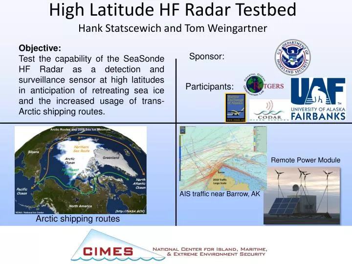
High Latitude HF Radar Testbed Hank Statscewich and Tom Weingartner. Objective: Test the capability of the SeaSonde HF Radar as a detection and surveillance sensor at high latitudes in anticipation of retreating sea ice and the increased usage of trans- Arctic shipping routes. Sponsor:.

E N D
High Latitude HF Radar TestbedHank Statscewich and Tom Weingartner Objective: Test the capability of the SeaSonde HF Radar as a detection and surveillance sensor at high latitudes in anticipation of retreating sea ice and the increased usage of trans- Arctic shipping routes. Sponsor: Participants: Remote Power Module AIS traffic near Barrow, AK Arctic shipping routes
Remote Power Module 3 Arctic Field Seasons Zero Down Time Sensors: HF Radar Automatic Id System (AIS) Met. Station Satellite Based Telemetry Provides Real Time Data
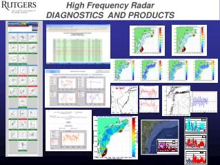
Daily Average Aug 29, 20125 MHz Long Range Network 6 km grid covering 80,000 Km2
Aug 22, 2012 16:00 UTC25 MHz High Resolution Network
Alaska 2012 Experiment Installed radars in June 2012 Collected vessel real time vessel detection data starting on July 9 Data transferred to Rutgers & NRL in real time 81 Unique Vessels operated within 200 km of Barrow in one month 8/10 – 9/10/2012
Technology Transfer • DHS Center for Secure and Resilient Maritime Commerce (CSR) • DARPA: Michigan Tech Research Institute: Enhanced surface target detection at high latitude • NORAD NORTHCOM: Modular Sensor System for persistent surveillance • USCG S&T – Rescue 21 and NAIS Network • NDA Agreements in Place with Boeing Corp and Battelle • This Maritime surveillance technique is not Arctic specific • Marshall Islands Illegal Fishing • Honolulu Harbor Monitoring
Thank You! hank.stats@alaska.edu www.ims.uaf.edu/artlab/