Download
1 / 9
90 likes | 154 Views
Interference Monitoring in the Central European GPS Geodynamic Reference Network. István Fejes FÖMI Satellite geodetic Observatory Penc, Hungary. ESF Workshop on “Active Protection of Passive Radio Services: towards a concerted strategy”. 28-29 October 2004, Cagliary, Italy.

E N D
Interference Monitoring in the Central European GPS Geodynamic Reference Network István Fejes FÖMI Satellite geodetic Observatory Penc, Hungary ESF Workshop on “Active Protection of Passive Radio Services: towards a concerted strategy”. 28-29 October 2004, Cagliary, Italy
The use of GNSS for Earth sciences • Presently the most important tool for monitoring tectonic processes beside VLBI and SLR • Applied in Earth rotation and reference frame studies • Atmospheric sciences • water vapor content determination • ionosphere studies • All these are based on the operation of high precision GPS networks. • High precision networks need high quality data • RFI harmful to GNSS signals • reduces S/N • leads to rough positioning errors • causes data loss • inhibits measurements
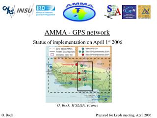
The Central Europe GPS Geodynamic Reference Network (2003) Epoch sites Permanent sites
Theinterference monitoring programme • Monitor CEGRN sites regularly • Collect and document user feed back • Report interference to frequency management authorities • Warn users
The monitoring rules • Equipment: Advantest spectrum analyser • Frequency bands: • Broad band – 1-2 GHz • GPS L1 – 1575.42MHz +/- 15 MHz • GPS L2 – 1227.6 MHz +/- 15 MHz • Galileo E5A-E5B, GPS L5 - 1164-1215 MHz • Galileo E4, E6 – 1250-1300 MHz • Galileo E2, L1, E1- 1550-1600 MHz • Optionally high resolution tracks
Conclusion • GNSS RFI mapping • Tool for site selection • Assists site quality monitoring • Assists GPS data reduction and analysis • Warns GPS users of „hot spots” • Alerts authorities • Mitigate harmful consequences