Download
1 / 11
110 likes | 114 Views
This workshop explores the GeoSciML Testbed and various technologies such as PostGIS, GeoNetwork, and Geoserver for mapping, cataloging, and serving geoscience data. It also covers schema mapping, translation, and WFS-X architecture.

E N D
Workshop WSS-03:GeoSciML V2 Testbed 3 Technologies- Tim Duffy IGC 2008 10 August 2008
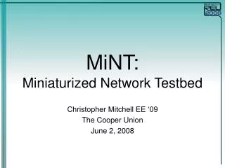
GeoSciML Cataogue Metadata (PostGis) CS-W GeoNetwork BRGM Architecture for CGI-GeoSciML Testbed 3 Geol. 1:1M (PostGis) WMS WFS Geol. 1:50k (PostGis) WMS WFS-X Component (servlet) WFS Boreholes (PostGis) WMS Vocabularies (eXist) XML DB WFS GSML Resources service GeoServer
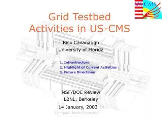
Schema mapping Schema translation Content translation WFS-X Architecture : a Web Feature Service with Transformation Client WFS-X (Java) Servlet geoserver DB with mapping descriptions WMS WFS geoserver WMS Mapping descriptions WFS • A WFS-X connected to various WFS with 3 components: • one for schema mapping with many operators, • one for schema translation (of elements name), • one for content translation (text values)
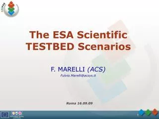
Field sites, unit descriptions, stratigraphic lexicon ORACLE 10g Some optimisation of data structures to make data delivery and mapping toGeoSciML easier. Maintenance RDBMS Distribution RDBMS FIREWALL ESRI Coverage or GDB(map polygon and line data) Mapserver custom Java application WMS GeoSciML WFS
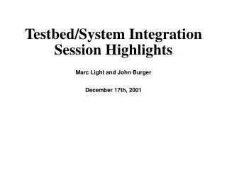
GIN architecture from Geological Survey of Canada – Natural Resources Canada
GIN architecture from Geological Survey of Canada – Natural Resources Canada Cocoon Mediator (‘Wrapper’, ‘Multi-tiered approach’) features • Can map many schemas (multiple profile) • Can merge several service results • Mediator handles both structure and vocabularies (although for simple cases) • Mediator can handle SLD and GetFeature translations • Has an internal Deegree component and can target external WFS
Future (by December 15th 2008) GeoSciML/OneGeology cookbooks • 1). How to Map your data to GeoSciML examples • 2). How to serve GeoSciML by WFS