Download
1 / 19
200 likes | 322 Views
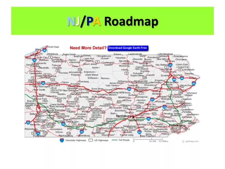
N J / P A Roadmap. 1. Map Scale. 1 in = approx. 11 mi 1 in = 17.4 km. 2. CBG. K-3 Southwest. 3. Pittsburgh to CBG. Less than 30 mi (approx. 20 mi) Mapquest = 21.67 mi. 4. Erie. North B-4. 5. CBG to Erie. Less than 160 mi (approx. 138 mi) Mapquest = 142.98 mi . 6. Shaded yellow.

E N D
1. Map Scale • 1 in = approx. 11 mi • 1 in = 17.4 km
2. CBG • K-3 • Southwest
3. Pittsburgh to CBG • Less than 30 mi (approx. 20 mi) • Mapquest = 21.67 mi
4. Erie • North • B-4
5. CBG to Erie • Less than 160 mi (approx. 138 mi) • Mapquest = 142.98 mi
6. Shaded yellow • City
7. Ohiopyle River • Youghiogheny R.
8. Youghiogheny R. length (in PA) • Approx. 66 mi N
9. Ohiopyle coordinates • M-6
10. 3 lakes entirely in PA = coordinates • L. Tionesta = E-7 • L. Arthur = G-4 • High Point L. = N-7
11. Slippery Rock to CBG • Approx. 62 mi • Mapquest = 65.72 mi
12. Pitt. To NYC • Approx. 383 mi • Mapquest = 370.87 mi
13. Shaded green areas • State parks & Nat’l./State forests
14. River between PA & NJ • Delaware R.
15. PA river that drains into Chesapeake Bay • Susquehanna R.
16. Green triangle w/in a green circle • Rest area w/ restrooms
17. 2 rivers that form the Ohio R. • Allegheny R. + Monongahela R.
18. Pitt to State College • Merge onto I-376 E/US-22 E toward MONROEVILLE. (Approx. 14 mi) • Merge onto US-22 E/WILLIAM PENN HWY via the exit on the LEFT toward MURRYSVILLE. (Approx. 75 mi) • Merge onto I-99 N/US-220 N via the exit on the LEFT toward ALTOONA. (Approx. 38 mi) • Take the US-322-BR E/ATHERTON ST exit, EXIT 69. (Approx. 11 mi) • Total = approx. 138 mi • Mapquest = 135.8 mi