Download
1 / 12
130 likes | 338 Views
EGNOS: a satellite navigation system for Europe, and an opportunity for Africa!. Michel Bosco Head, Galileo and EGNOS Applications and International Cooperation European Commission. EGNOS System Architecture. EGNOS is an SBAS that “augments” the signal of

E N D
EGNOS: a satellite navigation system for Europe, and an opportunity for Africa! Michel BoscoHead, Galileo and EGNOS Applications and International CooperationEuropean Commission
EGNOS System Architecture EGNOS is an SBAS that “augments” the signal of satellite positioning systems e.g. GPS, GALILEO, GLONASS 3 GEOSatellites 6 NavigationLand EarthStations Users &ServiceProviders 2 Support Facilities 4 MissionControlCentres GPS signals (in the future: GALILEO signals) 34 Ranging & Integrity MonitoringStations (RIMS)
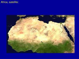
EGNOS Service Area INMARSAT AOR-E (15.5°W), ARTEMIS (21.3°E), INMARSAT IOR-W (25°E) EGNOSService Area EGNOS Satellite Footprints EGNOS is delivering a free open service over Europe since October 2009. It will deliver its services for at least > 20 yearsEGNOS satellites footprint cover also Africa.
Towards a worldwide SBAS coverage SDCM GAGAN Satellite coveragearea WAAS EGNOS EGNOSService Area MSAS Source: Stanford University
Technical feasibility and users’ interest A demonstration of the use of EGNOS for advanced rail traffic management, on low-density rail lines, Gauteng, South Africa 2005 Temporary EGNOS reference stations installed in several African countries: Chad, Cameroon, Central African Republic, Congo, Ethiopia, Kenya, Zambia, Namibia and South Africa; flight testing took place during a East-to-West flight from Dakar to Mombasa on 19-20 May 2005
EGNOS benefits in aviation • General operational benefits • Reduction in angle of approach (direct and curved) • Better lateral guidance • EGNOS enables a reduction in the decision height • Allows for IFR-like operation in non ILS-equipped airports • Increase in airports capacity • Increase in safety • Increase in flight capability (e.g. helicopters) • Expensive land based navaids can be avoided • Enables their long term decommissioning => lower terminal charges
37 % from Africa is 250km from an ILS equipped airport 87 % from Africa is 250km from a main or regional airport EGNOS potential Impact on Economic development and integration
Use of EGNOS for land management • Hydrographic survey • Crustal deformation monitoring • Landslides, flooding, volcanic crustal dynamics, etc • Improvement of National Geodetic Network • Cartography, cadastre and GIS data collection • Update of regional technical map, standardised cadastral surveying, georeferencing orthoimages satellite images, etc. • Structure monitoring • Bridges, dams, buildings • Civil Engineering • Support to meteorological analysis and forecasts
EGNOS benefits in Africa • Economic opening-up of isolated regions, reduction of access costs to regional centres • Improving transport infrastructure at once by making regional airports accessible to nationally and internationally • Reducing maintenance costs, safety and security of railways • Improving dramatically air and maritime transport safety • Impacting positively agriculture, mining, energy, and land management • Reduction of costs, increased safety and greater reactivity for humanitarian interventions • Building African capacity at managing large projects • Establishing pan-African infrastructure • Training of African users and operators • Reinforcement of African academic institutions
Results of a Cost-benefits analysis The use of SABS for Africa can bring benefits for various economic sectors Total benefits surpass 500€m over the 2012-2042 (30 years) period Millions of Euro 311 Total discountednet benefits (Discount rate of 8%) ~ 520€m
Programme implementation steps … - 2009 2010 2011 2012 • Preliminary studies • Cost Benefit Analysis • Programming (implementation and management plan) • Governance scheme • Political support • Funding • Detailed system design • Deployment of EGNOS across Africa • Service provision and operation Main issues being tackled with the African Union Commission: Rationale and benefits Technical alternatives Liability policy Certification policy Industrial issues Training needs and capacity building Exploitation Costs Governance structure Funding options Project management structure
Thank you for your attention Further information: http://www.satellite-navigation.eu/ michel.bosco@ec.europa.eu