Download
1 / 1
10 likes | 107 Views
Introduction. A new globally reanalysed GPS dataset for GIA and sea-level studies: technical details and preliminary time series. I an.thomas@ncl.ac.uk School of Civil Engineering and Geosciences, Newcastle University, UK. Ian Thomas , Matt King, Peter Clarke, Nigel Penna, David Lavall é e .

E N D
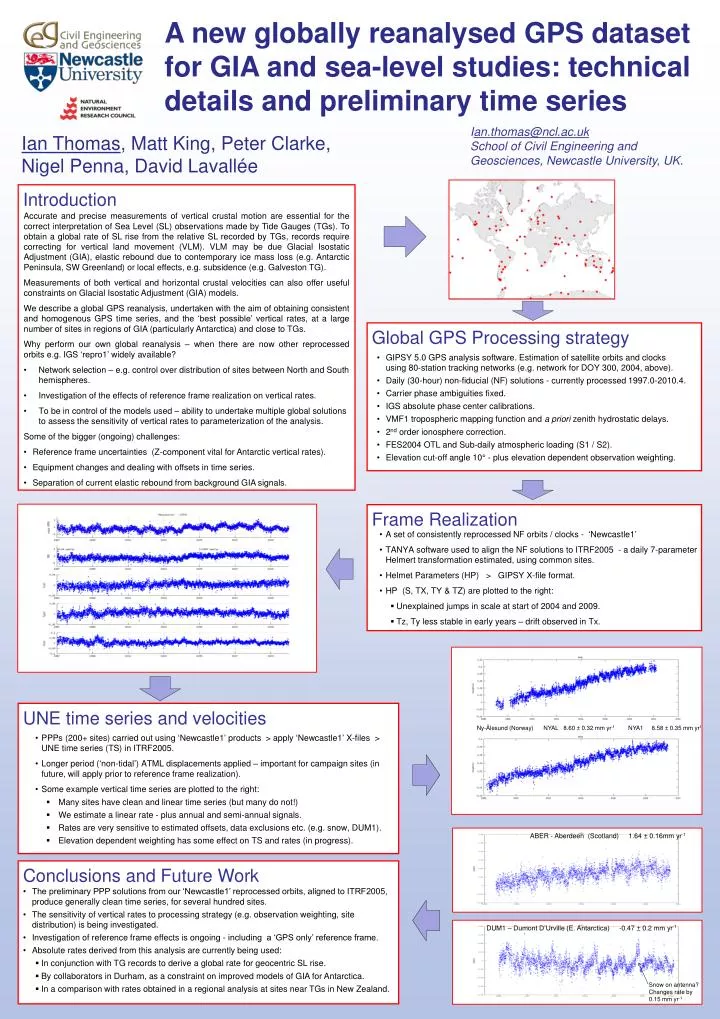
Introduction A new globally reanalysed GPS dataset for GIA and sea-level studies: technical details and preliminary time series Ian.thomas@ncl.ac.uk School of Civil Engineering and Geosciences, Newcastle University, UK. Ian Thomas, Matt King, Peter Clarke, Nigel Penna, David Lavallée • Accurate and precise measurements of vertical crustal motion are essential for the correct interpretation of Sea Level (SL) observations made by Tide Gauges (TGs). To obtain a global rate of SL rise from the relative SL recorded by TGs, records require correcting for vertical land movement (VLM). VLM may be due Glacial Isostatic Adjustment (GIA), elastic rebound due to contemporary ice mass loss (e.g. Antarctic Peninsula, SW Greenland) or local effects, e.g. subsidence (e.g. Galveston TG). • Measurements of both vertical and horizontal crustal velocities can also offer useful constraints on Glacial Isostatic Adjustment (GIA) models. • We describe a global GPS reanalysis, undertaken with the aim of obtaining consistent and homogenous GPS time series, and the ‘best possible’ vertical rates, at a large number of sites in regions of GIA (particularly Antarctica) and close to TGs. • Why perform our own global reanalysis – when there are now other reprocessed orbits e.g. IGS ‘repro1’ widely available? • Network selection – e.g. control over distribution of sites between North and South hemispheres. • Investigation of the effects of reference frame realization on vertical rates. • To be in control of the models used – ability to undertake multiple global solutions to assess the sensitivity of vertical rates to parameterization of the analysis. • Some of the bigger (ongoing) challenges: • Reference frame uncertainties (Z-component vital for Antarctic vertical rates). • Equipment changes and dealing with offsets in time series. • Separation of current elastic rebound from background GIA signals. Global GPS Processing strategy • GIPSY 5.0 GPS analysis software. Estimation of satellite orbits and clocks using80-station tracking networks (e.g. network for DOY 300, 2004, above). • Daily (30-hour) non-fiducial (NF) solutions - currently processed 1997.0-2010.4. • Carrier phase ambiguities fixed. • IGS absolute phasecenter calibrations. • VMF1 tropospheric mapping function and a priori zenith hydrostatic delays. • 2nd order ionosphere correction. • FES2004 OTL and Sub-daily atmospheric loading (S1 / S2). • Elevation cut-off angle 10° - plus elevation dependent observation weighting. Frame Realization • A set of consistently reprocessed NF orbits / clocks - ‘Newcastle1’ • TANYA software used to align the NF solutions to ITRF2005 - a daily 7-parameter Helmert transformation estimated, using common sites. • Helmet Parameters (HP) > GIPSY X-file format. • HP (S, TX, TY & TZ) are plotted to the right: • Unexplained jumps in scale at start of 2004 and 2009. • Tz, Ty less stable in early years – drift observed in Tx. UNE time series and velocities Ny-Ålesund(Norway) NYAL 8.60 ± 0.32 mm yr-1 NYA1 8.58 ± 0.35mm yr1 • PPPs (200+ sites) carried out using ‘Newcastle1’ products > apply ‘Newcastle1’ X-files > UNE time series (TS) in ITRF2005. • Longer period (‘non-tidal’) ATML displacements applied – important for campaign sites (in future, will apply prior to reference frame realization). • Some example vertical time series are plotted to the right: • Many sites have clean and linear time series (but many do not!) • We estimate a linear rate - plus annual and semi-annual signals. • Rates are very sensitive to estimated offsets, data exclusions etc. (e.g. snow, DUM1). • Elevation dependent weighting has some effect on TS and rates (in progress). ABER - Aberdeen (Scotland) 1.64 ± 0.16mm yr-1 • Conclusions and Future Work • The preliminary PPP solutions from our ‘Newcastle1’ reprocessed orbits, aligned to ITRF2005, produce generally clean time series, for several hundred sites. • The sensitivity of vertical rates to processing strategy (e.g. observation weighting, site distribution) is being investigated. • Investigation of reference frame effects is ongoing - including a ‘GPS only’ reference frame. • Absolute rates derived from this analysis are currently being used: • In conjunction with TG records to derive a global rate for geocentric SL rise. • By collaborators in Durham, as a constraint on improved models of GIA for Antarctica. • In a comparison with rates obtained in a regional analysis at sites near TGs in New Zealand. DUM1 – Dumont D’Urville(E. Antarctica) -0.47 ± 0.2 mm yr-1 Snow on antenna? Changes rate by 0.15 mm yr-1