Download
1 / 4
40 likes | 228 Views
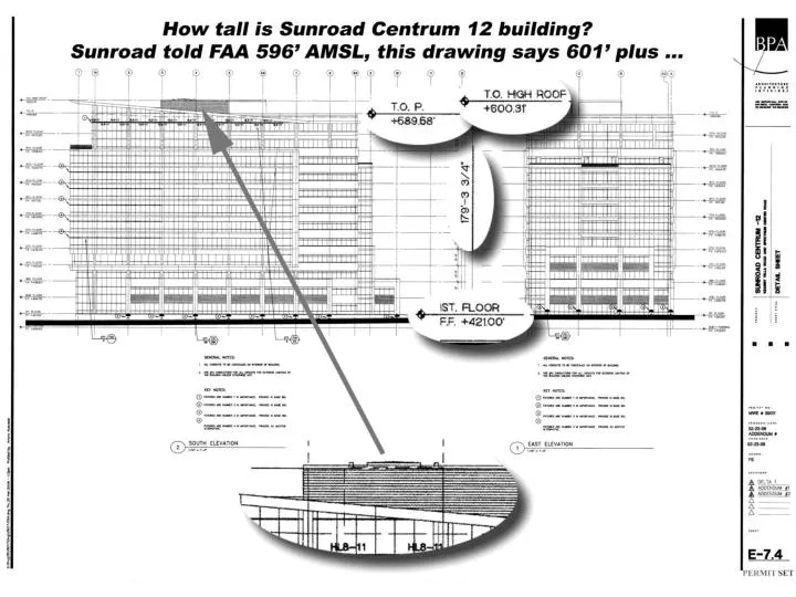
Flight path circle-to-land. 601* ft MSL (185 ft AGL). 25 ft penetration. 3,424 ft. 416 ft MSL (0 ft AGL). * Elevation from Sunroad plans. Sunroad Centrum 12 , 14, 16 Hazard to Air Navigation. 880 ft MSL (454 ft AGL) weather minimums for cloud heights.

E N D
Flight path circle-to-land 601* ft MSL (185 ft AGL) 25 ft penetration 3,424 ft 416 ft MSL (0 ft AGL) * Elevation from Sunroad plans Sunroad Centrum 12, 14, 16Hazard to Air Navigation 880 ft MSL (454 ft AGL) weather minimums for cloud heights FAA regulations establish minimum cloud heights for instrument approaches to the runway, measured above sea level (MSL = mean sea level) or above the ground (AGL = above ground level) FAA regulations also identify obstructions near the airport that penetrate a horizontal surface above all runways 576 ft MSL (150 ft AGL)horizontal surface10,000 from runway 426 ft MSL (0 ft AGL)highest point on runways
Sunroad Centrum 16? Sunroad Centrum 12, 14, 16Hazard to Air Navigation Sunroad Centrum 12, 14, 16Hazard to Air Navigation 880 ft MSL (454 ft AGL) weather minimums for cloud heights 69 ft penetration by14-story building at 645* ft 576 ft MSL (150 ft AGL)horizontal surface10,000 from runway 3,424 ft 426 ft MSL (0 ft AGL)highest point on runways 416 ft MSL (0 ft AGL) * Elevation from Sunroad plans
April 5: 180 ft proposed June 20: “agree to 160 ft … needed to reach resolution with FAA” June 22: 160 ft proposed July 7: building permit July 26: 180 ft proposed July 26: 180 ft actual April 24: “Presumed hazard” June 27: “No hazard” August 11: “Hazard” Sunroad FAA