Download
1 / 11
110 likes | 226 Views
Engaging Non-Geospatial Organizations. Kim Burns, ERSI Tom Christoffel, NVSRC John Clark, GSA. Jerry McFaul, USGS Rebecca Somers, Somers St. Claire Leslie Wollack, GOS. Action Team.

E N D
Kim Burns, ERSI Tom Christoffel, NVSRC John Clark, GSA Jerry McFaul, USGS Rebecca Somers, Somers St. Claire Leslie Wollack, GOS Action Team
Organizations, whose members are primarily users of spatial information and technology, not builders or producers of spatial information and technology. What are Non-Geospatial Organizations (NGOs)?
Short Term – Identify & engage ten organizations that would benefit most from use of Geospatial Information Long Term – Identify, Prioritize, & Engage another 30 plus organizations that would benefit from use of Geospatial Information Leverage Outreach Efforts of the other Action Plans especially the Strategic Communications Plan Outreach Strategy
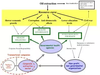
I: IDENTIFICATION OF ORGANIZATIONAL INTERSTS AND CHARACTERISTICS Non-geospatial Organizations: Outreach Plan and Approach 1. 2. 3. 4. • Organizations: • Categories • Impacts • Interests: • Specific to org. • General • Tools: • Specific to org. • General • Challenges: • Specific to org. • General 1. 5. How to Get Organizations’ Attention • Organization • Police Assn. • NGA • Interests • Crime Prevention • Homeland Sec. • Homeland Sec. • Economic Dev. II: INTEGRATION Potential Approach 6. Organization Police Assn. Real Estate Interests Homeland Sec. Access to property data How to Work With Them Awards Tools Challenges Limited funds Limited technology Potential Impacts High visibility No publicity III: ANALYSIS & PRIORITIZATION Benefit/Cost 7. • Organization • Police Assn. • Real Estate • Benefit/Cost • High • Low Priority Now: 2006 ID specific orgs & plan Med: 2007-2010 Refine analysis ID types Low: 2011 & beyond don’t invest resources yet 8. Strategy Establish partnership Provide education Learn more about them General, public information NGA, NACo, Police Assn. Awareness, beginning use of GIS Isolated GIS use, Low potential for visibility & assistance 9.. Next Steps IV: ACTION PLAN
A Three-Tiered Approach Ranked according to relative costs and benefits Low to Medium Investment with High Impact Medium Investment with High to Medium Impact Low to High with Medium to Low Impact Outreach Strategy Contact Targeted Organizations to discuss their issues/interests & how geospatial information addresses them Identify FGDC/NSDI Resources (Grants/Technical Assistance) to Facilitate their Use of Spatial Data Prioritization & Strategy
Establish an Interagency FGDC Outreach Team (s) Target & Participate in Select Number of Professional Management Association Conferences/Events over the Next 18 months consistent with the recommendations from all action teams Implement Outreach Model that Includes our Private Sector Partners Fund & Implement the proposed Regional Intensive Geospatial Training Pilot in Virginia’s Northern Shenandoah Valley Action Plan - Next Steps