Download
1 / 9
100 likes | 219 Views
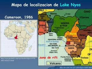
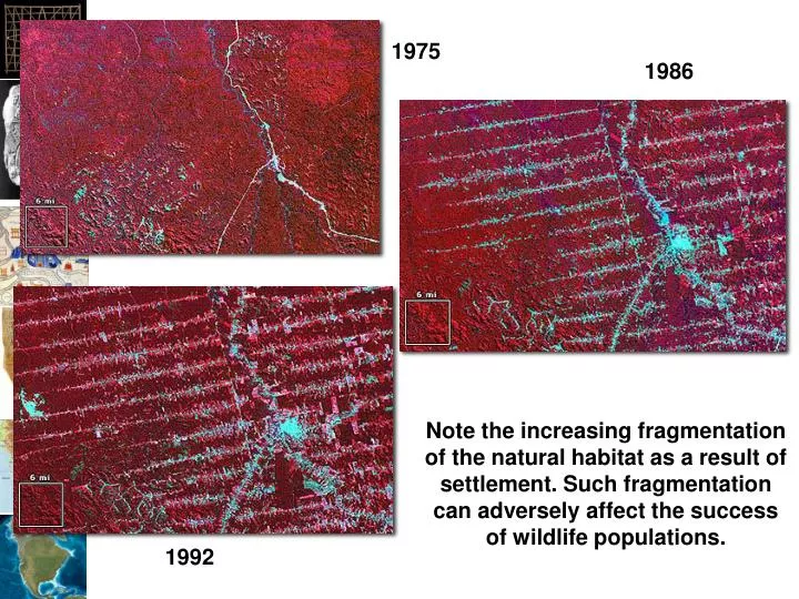
1975. 1986. 1992. Note the increasing fragmentation of the natural habitat as a result of settlement. Such fragmentation can adversely affect the success of wildlife populations. FragStats. http://www.umass.edu/landeco/research/fragstats/fragstats.html. FRAGSTATS Overview.

E N D
1975 1986 1992 Note the increasing fragmentation of the natural habitat as a result of settlement. Such fragmentation can adversely affect the success of wildlife populations.
FragStats http://www.umass.edu/landeco/research/fragstats/fragstats.html
FRAGSTATS Overview • Derives a set of useful landscape metrics • Public domain code developed by Kevin McGarigal and Barbara Marks under U.S.F.S. funding
Situation • FragStats only supporting 4.x from now on • There tutorial data is in ArcGRID format • Following FragStats instructions on adding support for ArcGRIDs results in: • Only other formats supported are ASCII GRID and binary (neither appear to work)
FRAGSTATS Fundamentals • PATCH… individual parcel (Polygon) A single homogeneous landscape unit with consistent vegetation characteristics, e.g. dominant species, avg. tree height, horizontal density ,etc. A single Mixed Wood polygon (stand) CLASS… sets of similar parcels LANDSCAPE… all parcels within an area
FRAGSTATS Fundamentals PATCH… individual parcel (Polygon) • CLASS… sets of similar parcels All Mixed Wood polygons (stands) LANDSCAPE… all parcels within an area
FRAGSTATS Fundamentals PATCH… individual parcel (Polygon) CLASS… sets of similar parcels • LANDSCAPE… all parcels within an area “of interacting ecosystems” e.g., all polygons within a given geographic area (landscape mosaic)
FRAGSTATS Output Metrics • Area Metrics (6), • Patch Density, Size and Variability Metrics (5), • Edge Metrics (8), • Shape Metrics (8), • Core Area Metrics (15), • Nearest Neighbor Metrics (6), • Diversity Metrics (9), • Contagion and Interspersion Metrics (2) • …59 individual indices (US Forest Service 1995 Report PNW-GTR-351)