Download
1 / 22
220 likes | 402 Views
OC 3255 REMOTE SENSING OF THE ATMOSPHERE AND OCEANS. Course Details. Instructor - Prof. Robin Tokmakian Office 337A (near west end elevators) Hours:????? Phone x3255 Email rtt@nps.navy.mil Lectures: M,Tu, W, Th :11:00am ; rm Spanagle 310 LAB Instructor - Ms. Donna Burych

E N D
OC 3255 REMOTE SENSING OF THE ATMOSPHERE AND OCEANS
Course Details • Instructor - Prof. Robin Tokmakian • Office 337A (near west end elevators) • Hours:????? • Phone x3255 • Email rtt@nps.navy.mil • Lectures: M,Tu, W, Th :11:00am ; rm Spanagle 310 • LAB • Instructor - Ms. Donna Burych • Office 334; Phone x2737; Email burych@nps.navy.mil • Labs: Friday 8:00am; Spanagle 341 • TEXTBOOK/REFERENCE • * Satellite Meteorology - Kidder & Vonder Haar - required text • * Methods of Satellite Oceanography - Stewart - Overnight Reserve • Grades: Exam I,II,III - 25% each, Lab 10%; paper 15%
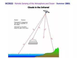
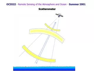
Week of - 9 July week 1 • Mo: Organization, Introduction and Motivation • Tu: A Brief History of Environmental Satellite Systems • We: continued • Th: Satellite Orbits • Fr: LAB1- Introduction to Satellite Imagery • Week of - 16 July week 2 • Mo: Tracking/Navigation • Tu: Review of Basic Definitions EMR/ Radiative Transfer • We: Radiative Transfer for Remote Sensing • Th: Special Solutions • Fr: Lab2- Image Manipulation OC3522Remote Sensing of the Atmosphere and OceanSummer 2001 • Week of - 20 August week 7 • Mo: Atmospheric Sounding Solutions • Tu: The Retrieval Problem/Sounding Systems • We: Detection of Water Vapor • Th : Water Vapor Imagery • Fr: LAB4 - Cloud Classification • Week of - 27 August week 8 • Mo: Detection of Atmospheric Constituents • Tu: continued • We: Introduction to Microwave Radiative Transfer • Th: Exam review • Fr: (LAB PERIOD) EXAM II • Week of - 3 September week 9 • Mo: HOLIDAY • Tu: Passive Microwave Applications - Ocean • We: MW Ocean II • Th: MW Atmosphere • Fr: LAB 5 - ICE Applications - ARC-VIEW • Week of - 10 September week 10 • Mo: Active Microwave - Radar Equation • Tu: Altimeter-I • We: Altimeter-II • Th: Synthetic Aperture Radar-I • Week of - 17 September week 11 • Mo: Synthetic Aperture Radar-II • Tu: Scatterometer • We: FUTURE • Th : Exam Review / PAPER DUE • Wed Sept. 26 8AM FINALS WEEK: EXAM III • Week of - 23 July week 3 • Mo: Introduction to Visible/Solar Applications • Scattering by Aerosols • Tu: Aerosol Applications • We: Scattering by Clouds/Applications • Th: Ocean Color • Week of - 30 July week 4 • Mo: Color Applications • Tu: Land Surface Applications We: Lidar and ApplicationsTh: Examine review • Fr: (LAB PERIOD) EXAM I • Week of - 6 August week 5 • Mo: IR Theory • Tu: SST - Theory and Applications • We: Clouds in the IR Th: Multispectral Cloud Analysis • Fr: LAB3 - SST Analysis • Week of - 13 August week 6 • Mo: NO CLASS • Tu: ARC-VIEW INTRO Parsons • We: Guest Lecture - CODAR Paduan • Th: NO CLASS
PAPER Choose one atmospheric or oceanic physical property Describe remote sensing sensors that can measure this quantity either directly or indirectly Describe applications Tell me what property/parameter by July 30. Everyone will have a unique parameter/property. Paper - 5 pages, not including figures if you need them. DUE: SEPT. 21 Examples: SST Winds; boundary layer or upper levels Clouds Ice Ocean Currents Ocean temperatures Ocean biology Aerosols Water vapor/precipitation Waves
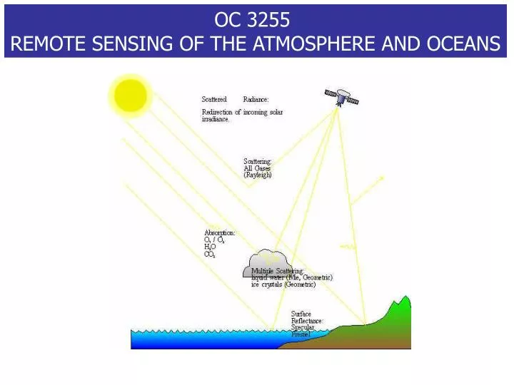
Course ObjectivesThe primary objective of this course is to understand how radiance measurements at the top of the atmosphere provide information about characteristics of the atmosphere and ocean. To that end we must ... • understand the basic physical characteristics of radiation: • and what approximations are useful for understanding radiance at the top of the atmosphere for different wavelength regions. • review a brief history of environmental satellites and understand their orbit and sensor characteristics. • understand the application of satellite measurement techniques to the detection of: • clouds (aerosols) and their characteristics from visible and IR measurements, • oceanic productivity through ocean color measurements, • temperature profiles from multispectral IR and MW measurements • atmospheric constituents (H2O(v) and O3) from multispectral IR and MW measurements • sea surface temperature from IR measurements • precipitation, wind speed, water vapor and liquid water from passive microwave measurements, • sea state, sea surface height, wave height, currents, winds and other properties from active microwave measurements.
Advantages /Disadvantages • Advantages of remote sensing: • global/large spatial coverage, • generally good repeat temporal coverage, • rapid/instantaneous survey (snapshot), • measurements where in-situ measurements are not available or difficult to make for geographical and political/military reasons, • measurements do not interfere with the process being measured, etc. Remote sensing is the acquisition of geophysical/environmental data from sensing devices remote from the feature of interest. Usually we are not measuring directly the parameter of interest, we infer it from other properties (examples: astrophysics (properties/composition/structure of planets/stars from the radiation they emit), ocean tomography (variations in sound propagation to estimate temperature/density variability in the ocean). In satellite remote sensing the reception of EM energy at a sensor located in space is used to estimate physical (and also biochemical) processes occurring in the earth's atmosphere, land and ocean. • Disadvantages: • cannot measure all parameters (ex: SST yes, SSS no yet), • opacity of atmosphere, • limited resolution in both horizontal and vertical directions, • less accurate than in-situ, • in-situ verification/calibration necessary but sometime difficult, etc. • Parameters that are (or have been) successfully sensed remotely from satellite: • Ocean: color (chlorophyll), SST, sea state, surface height, wave height, internal waves, etc. ; geoid • Atmosphere: surface and higher winds, aerosols, ozone, clouds, CO2, precip. water, etc. ; rain rate • The remote sensing course is one of the most useful and relevant for your career . Military applications include: • Visible: ocean color , turbidity of coastal waters (amphibious operations) , clouds • Infrared: sea surface temperature; input for weather models • Passive and Active Microwave: sea surface characteristics, currents, winds, significant wave height, ice coverage, etc. • geoid
Shuttle Photos Soot-blackened snowTroitsk Siberia
Kuwait Oil Fires Hurricane Elena in the Gulf of Mexico on September 1, 1985. Alaskan Glaciers
Frontal System and Thunderstorms, Florida April 1984 Monsoonal Thunderstorms, Bangladesh and India July 1985 Typhoon Yuri, Pacific Ocean November 1991
Klyuchevskaya Volcano, Kamchatka Peninsula, Russia October 1994
Satellite “Products” current
http://rst.gsfc.nasa.gov/TofC/table.html SPOT (France) JERS (Japan) Orlando Airport Tokyo IRS (India) Southern Iran
Downtown Area of Tokyo (Around Shinjyuku) (X-band, VV, 5 km x 4 km, flight direction: right to left, illumination: top to bottom)
Autonomous Temperature and Salinity profiling http://hrp.whoi.edu/floats/spalace_overv.html Salinity Profiling Autonomous LAgrangian Circlulation Explorer (S-PALACE) floats are new tools for acquiring temperature and salinity profiles in remote or inhospitable regions. These autonomous floats have the advantage that once deployed, no ships or people are required on site to obtain the measurements. The data is collected by the float and telemetered back to land via satellite link. Floats can last as long as 150 profiles or more, giving a 4-5 year lifetime on a two-week cycle. By analysing the data as it is returned, we can learn more about the characteristics of the upper ocean's heat and salt content as well as its circulation. S-PALACE data are expected to be important inputs to predictive ocean-atmosphere coupled models in the future, as greater numbers are deployed in the global ocean.
CODAR Coastal OCEAN DYNAMICS APPLICATIONS RADAR http://www.oc.nps.navy.mil/~radlab/radar.html
Daily Views West Coast GOES IR West Coast GOES VIS West Coast GOES WV Current Monterey VIS Current Los Angeles VIS Current Sacramento VIS Current Eureka VIS US Radar Summary Northern California Radar Summary SFO Radar