Download
1 / 27
270 likes | 370 Views
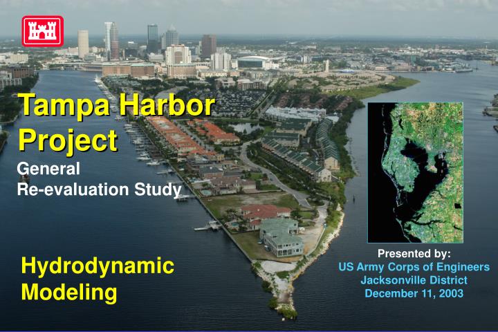
Tampa Harbor Project. General Re-evaluation Study. Presented by: US Army Corps of Engineers Jacksonville District December 11, 2003. Hydrodynamic Modeling. Introduction. Tampa Harbor Project General Re-evaluation Study. USACE South Atlantic Division

E N D
Tampa Harbor Project General Re-evaluation Study Presented by: US Army Corps of Engineers Jacksonville DistrictDecember 11, 2003 Hydrodynamic Modeling
Introduction Tampa Harbor Project General Re-evaluation Study • USACE South Atlantic Division • Directed Jacksonville District to seek • support for modeling tools & procedures • from • Sponsors • Tampa Port Authority, City of St. Pete • Other stakeholders • ABM, TBEP, USGS
Outline Tampa Harbor Project General Re-evaluation Study • Introduction • Purpose for Hydrodynamic Modeling • Model Selection • Alternatives • Scope of Modeling • Other Tasks
Introduction Tampa Harbor Project General Re-evaluation Study • Navigation Projects • Tampa Harbor GRS • St Petersburg GRS • Previous Corps Funded Hydro Model • Circulation Changes due to Dredge & Fill (Goodwin, ’87,’91)
N YBOR PORT SUTTON CLEARWATER PORT TAMPA ALAFIA RIVER BIG BEND Gulf of Mexico ST. PETERSBURG CHANNEL LOCATION MAP TAMPA HARBOR LOCATION MAP LOCATION MAP TAMPA HARBOR PROJECT NASSAU COUNTY NASSAU COUNTY TAMPA BAY PORT MANATEE
Purpose of Hydrodynamic Modeling Tampa Harbor Project General Re-evaluation Study • Provide currents to Ship Simulator • Evaluate changes to circulation/salinity • due to channel modifications
Existing Conditions • Strong wind, current and tide considerations • 43-foot deep main Federal channel by 500-foot wide (Cut A-F) • Increased vessel sizes and port calls • Vessel accident history from 1980 resulting in loss of life, navigation delays & environmental damage • Tampa Bay Safety Guidelines Committee established • Vessel Handling Guidelines for Movement established • Commerce light-loaded, traffic flow impeded, navigation delays • Tampa Harbor Safety Zones established • Tampa Harbor Security Zones established
Model Selection Tampa Harbor Project General Re-evaluation Study • Criteria • Represent Channel Mods • Local Mass Conservation • Model Types • Structured Grid • Orthogonal – ECOM, EFDC • Boundary Fitted – CH3D • Nested – Mike2/3 • Unstructured Grid • Finite Element – ADCIRC, RMA, MIKE FM • Finite Volume – UnTrim, ELCIRC, FVCOM MIKE FM, Delft
MIKE FM/FV(DHI) UnTrim(Casulli & Walters 2000) • Unstructured grid • Mass Conservation • Stability independent of surface wave speed • Degenerate to 2D & 1D • Flooding & Drying • Proprietary • MIKE Zero • (Sediment Transport) • (Water Quality) • (Ecolab) • Stability dep. Surface wave speed • Proprietary ELCIRC(Oregon Grad Institute 2001) • Open Source
Alternatives Tampa Harbor Project General Re-evaluation Study • Six preliminary plans • 2 to 6 alternatives for each
Preliminary Alternative Plans Daisy Orchid Rose Zinnia Violet Iris Tampa Harbor Project General Re-evaluation Study
Scope of Modeling Tampa Harbor Project General Re-evaluation Study • Model Simulations • Calibration & Verification (existing data) • Existing Conditions – Base year w/o project (future w/o ?) • Three Alternative Project Plans • Time Scales • Project Alternative Optimization – 30 days • Impacts to Circulation & Salinity – Seasonal (3-4 months)
Revised Scope • OLD • A re-evaluation of the entire harbor project • Feasibility-level study • NEW • Main ship channel congestion relief measures • - Anchorage areas • - Loop channel • - Non-structural alternatives
Other Tasks Tampa Harbor Project General Re-evaluation Study • Ship Simulator - optimize channel design • Channel Shoaling- Diagnostic Modeling System • PORTSIM- queuing model/ economic analysis • Ship Wake Analysis - potential impact on seagrass • Harbor Oscillation – limited to local areas
US Army Corpsof EngineersJacksonville District Thank You Point of contact: Steve Bratos 904-232-1824 steven.m.bratos@saj02.usace.army.mil
Project Schedule Tampa Harbor Project General Re-evaluation Study • 1 Mar 04 - Tampa & St Pete • Calibration / Verification • Existing Condition • 1 April 04 - Alternatives (~ 3 model simulations) • 1 Jun 04 - Recommended Plan, Locally Preferred Plan
Vessel Calls & Cargo Type Tampa Distribution of Calls by Vessel & Cargo Type CY 2001 VESSELL TYPE CARGO TYPE % OF CALLS Cruise Ships Passengers 6% Break Bulk, Neo-bulk, Containerized General Cargo Ships 18% Bulk Carriers & Barges Dry Bulk 29% Tankers & Barges Petroleum Products 47%
Environmental Resources Diverse, high quality fish & wildlife resources within Tampa Bay • Bethnic Resources • Seagrass - beds extensive; high value fisheries nursery • Soft bottom – sand/muck (80%) • Hardbottom – invertebrate & fish habitat (850 acres) • West Indian Manatee – extensive protection zones (FWS, DEP, FWC) • Estuarine Resources • Marshes & mangroves – fisheries habitat • Mud flats & salt barrens – microscopic organisms fuel for Bay productivity • Associated uplands – foraging, nesting, loafing habitat (bald eagle, osprey, wood storks) • Low salinity habitats – oysters thrive “Charting the Course,” CCMP for Tampa Bay, December 1996
Study Guidance • ER 1105-2-100 - “Revised Planning Guidance Notebook” • ER 1165-2-1 - “Digest of Water Resources Policies & Authorities” • EM 1110-2-1613 - “Navigation Design Safety Component” • ER 1165-2-131 – “Over Depth Dredging” • EC 1165-2-203 – “Internal Technical Reviews” • USCG 33 CFR 165 – “Security Zones” • Port of Tampa Authority Input • Tampa Harbor Pilot Association Input
Vessel Tonnage & Movement CY 2001 Tampa Area Ports’ Tonnage and Vessel Movements * CY 2001 INBOUND & OUTBOUND TRIPS TAMPA AREA PORTS CY 2001 SHORT TONS Tampa 45,793,544 6,930 Port Manatee 3,801,621 654 Weedon Island 1,038,674 124 St. Petersburg 52,000 852 Total 50,685,839 8,560 * WBC of the U.S., CY 2001, Part 2 – Waterways and Harbors, Gulf Coast, Mississippi River System and Antilles
Critical Milestones • Begin study • Feasibility Scoping meeting • Complete Draft GRR • Alternative Formulation Briefing • Project Guidance Memorandum Comments • Release Draft GRR to the Public • Complete Public Coordination Period • Submit Final GRR to MSC * • Division Commander’s Public Notice (begin design phase) • Authorization Water Resources Development Act of 2006 • Begin construction • Complete construction 4/11/02 9/16/03 6/30/04 9/13/04 10/26/04 2/9/05 4/7/05 7/19/05 03/10/06 2007 (tentative) 2010