Download
1 / 1
10 likes | 82 Views
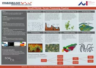
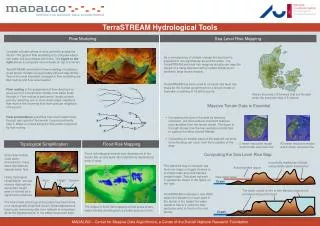
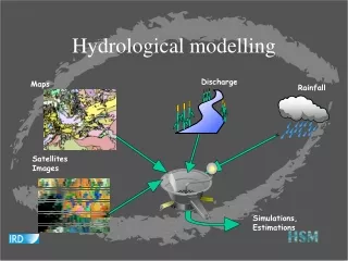
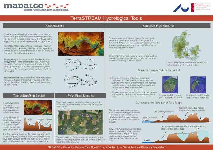
Area. Height. Volume. TerraSTREAM Hydrological Tools. Consider a terrain where it rains uniformly across the terrain. The goal of flow modelling is to compute where rain water will accumulate into rivers. The figure to the right shows a computed river network on top of a terrain.

E N D
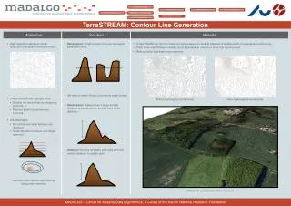
Area Height Volume TerraSTREAM Hydrological Tools Consider a terrain where it rains uniformly across the terrain. The goal of flow modelling is to compute where rain water will accumulate into rivers. The figure to the right shows a computed river network on top of a terrain. TerraSTREAM can perform flow modelling on arbitrary sized terrain models using provably efficient algorithms. Two of the most important concepts in flow modelling are flow routing and flow accumulation. Incorrectly marked as flooded using simple plane intersection • As a consequence of climate change the sea level is expected to rise significantly around the globe. The TerraSTREAM sea level rise mapping module can map the impact of a rising sea level with provable efficiency on arbitrarily large terrain models. Actual flooded region 2 1 1 2 2 2 1 8 14 New water level • TerraSTREAM has been used to compute sea level rise maps for the Danish government on a terrain model of Denmark consisting of 18 billion points. 9 1 3 1 • Flow routing is the assignment of flow directions to every point of a terrain that models how water flows through it. Flow routing is performed locally at each point by selecting one or more down slope neighbors that receive the incoming flow from upslope neighbors of the point. Ocean 1 • Shows the parts of Denmark that are flooded when the sea level rises 3.5 meters. Flow accumulation quantifies how much water flows through each point of the terrain if poured uniformly onto it. Water is routed along the flow paths computed by flow routing. • Decreasing the size of the data by lowering resolution, will often remove important features such as dikes from the terrain model. The figure to the right shows how the low resolution model fails to capture the dikes around Mandø. • Computing on smaller parts of the data will not work since flooding can occur from the boundary of the data The water needs to rise to this elevation before the corresponding points flood 2 meter resolution model and 2 meter sea level rise 80 meter resolution model and 2 meter sea level rise Since flow models route water downstream, many small depressions impede water flow. Ocean The standard way to compute sea level rise maps on bigger terrains is to simply mark all points below a certain height. This does not work in general as shown in the figure on the right. • Using topological simplification we can remove depressions using their height, area or volume as a significance measure. TerraSTREAM computes a new DEM where the elevation of each point in the terrain is the height the water needs to rise to in order for that particular point to flood in the real terrain. The flow model at the top of the poster has been done on a topologically simplified terrain. Small depressions have been removed so the river network is connected while the big depression in the valley have been kept. MADALGO – Center for Massive Data Algorithmics, a Center of the Danish National Research Foundation