Download
1 / 2
20 likes | 167 Views
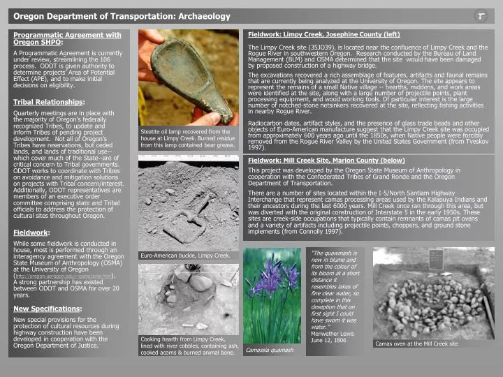
Steatite oil lamp recovered from the house at Limpy Creek. Burned residue from this lamp contained bear grease. Euro-American buckle, Limpy Creek. Camas oven at the Mill Creek site. Camassia quamash. Oregon Department of Transportation: Archaeology.

E N D
Steatite oil lamp recovered from the house at Limpy Creek. Burned residue from this lamp contained bear grease. Euro-American buckle, Limpy Creek. Camas oven at the Mill Creek site Camassia quamash Oregon Department of Transportation: Archaeology Programmatic Agreement with Oregon SHPO: A Programmatic Agreement is currently under review, streamlining the 106 process. ODOT is given authority to determine projects’ Area of Potential Effect (APE), and to make initial decisions on eligibility. Tribal Relationships: Quarterly meetings are in place with the majority of Oregon’s federally recognized Tribes, to update and inform Tribes of pending project development. Not all of Oregon’s Tribes have reservations, but ceded lands, and lands of traditional use--which cover much of the State--are of critical concern to Tribal governments. ODOT works to coordinate with Tribes on avoidance and mitigation solutions on projects with Tribal concern/interest. Additionally, ODOT representatives are members of an executive order committee comprising state and Tribal officials to address the protection of cultural sites throughout Oregon. Fieldwork: While some fieldwork is conducted in house, most is performed through an interagency agreement with the Oregon State Museum of Anthropology (OSMA) at the University of Oregon (http://oregon.uoregon.edu/~osma/sma.htm). A strong partnership has existed between ODOT and OSMA for over 20 years. New Specifications: New special provisions for the protection of cultural resources during highway construction have been developed in cooperation with the Oregon Department of Justice. Fieldwork: Limpy Creek, Josephine County (left) The Limpy Creek site (35JO39), is located near the confluence of Limpy Creek and the Rogue River in southwestern Oregon. Research conducted by the Bureau of Land Management (BLM) and OSMA determined that the site would have been damaged by proposed construction of a highway bridge. The excavations recovered a rich assemblage of features, artifacts and faunal remains that are currently being analyzed at the University of Oregon. The site appears to represent the remains of a small Native village -- hearths, middens, and work areas were identified at the site, along with a large number of projectile points, plant processing equipment, and wood working tools. Of particular interest is the large number of notched-stone netsinkers recovered at the site, reflecting fishing activities in nearby Rogue River. Radiocarbon dates, artifact styles, and the presence of glass trade beads and other objects of Euro-American manufacture suggest that the Limpy Creek site was occupied from approximately 600 years ago until the 1850s, when Native people were forcibly removed from the Rogue River Valley by the United States Government (from Tveskov 1997). Fieldwork: Mill Creek Site, Marion County (below) This project was developed by the Oregon State Museum of Anthropology in cooperation with the Confederated Tribes of Grand Ronde and the Oregon Department of Transportation. There are a number of sites located within the I-5/North Santiam Highway Interchange that represent camas processing areas used by the Kalapuya Indians and their ancestors during the last 6000 years. Mill Creek once ran through this area, but was diverted with the original construction of Interstate 5 in the early 1950s. These sites are creek-side occupations that typically contain remnants of camas pit ovens and a variety of artifacts including projectile points, choppers, and ground stone implements (from Connolly 1997). “The quawmash is now in blume and from the colour of its bloom at a short distance it resembles lakes of fine clear water, so complete in this deseption that on first sight I could have sworn it was water.” Meriwether Lewis June 12, 1806 Cooking hearth from Limpy Creek, lined with river cobbles, containing ash, cooked acorns & burned animal bone.
View of Newberry Volcano caldera from Paulina Peak on the south caldera wall. The Early Holocene-age Paulina Lake Site lies at the lake's western outlet. Living floor from Newberry Crater, ca. 9500 BCE Soil profile from the Paulina Lake Site. The light layer is 7,700 year old Mazama tephra. Example of straight-line maps created through GIS database for Salmon restoration initiative (after Neil et al. 2001). GIS will help routine highway maintenance activities avoid sensitive resources along highway right-of-way (from Neil et al. 2001). Example of aerial maps with GIS layers overlaid (from Neil et al. 2001). Oregon Department of Transportation: Archaeology Fieldwork: Newberry Caldera, Deschutes County (right) Archaeological Investigations were conducted by the State Museum of Anthropology, within the caldera of central Oregon's Newberry Volcano. The work was jointly funded by the Federal Highway Administration and the Deschutes National Forest, in a contract administered through the Oregon Department of Transportation. The caldera contains a number of flows of toolstone quality obsidian that was quarried throughout the Holocene. Excavations focused most intensively on Early Holocene occupations at the Paulina Lake site (35DS34), dating from 11,000 to 7700 (dendrocalibrated) years ago. Specialized studies included sourcing of obsidian toolstone recovered from archaeological contexts, and research on the distribution of products from the Newberry obsidian quarries outside the caldera (from Tveskov & Connolly 1997) Dr. Dennis Jenkins exposing stone tools in the pre-Mazama sediments at Paulina Lake Site. GIS, Cultural Resources and Data mapping (bottom right): In cooperation with the Oregon State Historic Preservation Office (SHPO), BLM, Forest Service and Natural Resources Conservation Services, ODOT is developing a statewide digital, geographically-referenced database of historic and archaeological survey site boundaries (with appropriate attribute data), to further transportation planning and historic/archaeological research efforts in Oregon. Through GIS, cost-effective analyses, simple overlays of different information types, and production of precision maps and other visual aids will be available to registered users through the internet. Similar efforts have been implemented for primarily natural resources, to support a state-wide executive order for Salmon Restoration. ODOT has worked with Mason, Bruce & Girard (Portland, Ore.) and Pacific Meridian Resources (Emeryville, Calif.) to locate, identify and inventory natural resource features along nearly 6,000 miles of Oregon roadways. The companies used high-resolution (2’), false-color infrared digital aerial imagery from Emerge (Andover, Mass.), along with global positioning system (GPS), geographic information system (GIS) and laser surveying technologies to inventory and map natural features. The objective is to provide ODOT’s roadway maintenance staff with accurate locations of sensitive natural and cultural resource features, so that such features won’t be harmed inadvertently by routine maintenance practices. The information is helping ODOT accomplish its goal of providing an effective transportation system while actively protecting the environment (Neil et al 2001). See http://www.odot.state.or.us/eshtm/odot_salmon.htm. For more information: http://www. odot.state.or.us/eshtm/arch.htm Hal Gard, Senior Archaeologist Kirsten Anderson, Archaeologist howard.a.gard@odot.state.or.us kirsten.j.anderson@odot.state.or.us Pages developed by Kirsten Anderson, ODOT Environmental Services