Download

1 / 15
150 likes | 253 Views
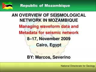
Republic of Mozambique. AN OVERVIEW OF SEISMOLOGICAL NETWORK IN MOZAMBIQUE Managing waveform data and Metadata for seismic network 8–17, November 2009 Cairo, Egypt BY: Marcos, Severino. National Directorate for Geology. Contents. Mozambique location; Background; Seismological Network;

E N D
Republic of Mozambique AN OVERVIEW OF SEISMOLOGICAL NETWORK IN MOZAMBIQUE Managing waveform data and Metadata for seismic network 8–17, November 2009 Cairo, Egypt BY: Marcos, Severino National Directorate for Geology
Contents • Mozambique location; • Background; • Seismological Network; • On going project; • Human Resources; and • Technical cooperation Objectives National Directorate for Geology
Mozambique location LOCATION OF MOZAMBIQUE • Geographical location: • Southern part of Africa • Meridian 30° and 42° East • Parallel 11° and 27° South • Total area: • 799 380 Km² • 6 000 000 ha arable land • 3 866 368 ha cultivated • Population: • 20,5 millions • 80% live in the countryside • 20% live in urban area National Directorate for Geology
Background • Seismological observation in Mozambique started in 1957, after a series of big earthquakes occurred between 1950-1954. • The first Seismological Station was installed in June1957, in Maputo city, and operated by the National Service of Meteorology (Geophysical Department); • In 1989 the Geophysical Department was transferred to National Directorate for Geology; Objectives National Directorate for Geology
Seismological Network • Is composed by 5 stations: • Changalane; • Manica; • Tete; • Nampula; and • Lichinga; • The transmission of data between these stations including Changalane Broad Band Station (Africa Array Project) and Maputo Centre of Analysis is by GPRS System. National Directorate for Geology
Seismograph Station Summary National Directorate for Geology
Seismological net work location National Directorate for Geology
Seismological Network Objectives National Directorate for Geology
ON GOING PROJECT • With the financing of Mozambique Government to increase the density of seismological stations four new station, namely Massingir, Mocuba, Mueda was constructed and Vilankulo is in building. • Procurement for purchasing of four new full stations are on going. Objectives National Directorate for Geology
TipicalSeismogrphic Station National Directorate for Geology
CNG Seismogrphic Station (AfricaArray project) National Directorate for Geology
Human Resources • 1 Seismologist • 5Analysts (technicians) • 2 Electronic technician; and • 5 Station operators Objectives National Directorate for Geology
Technical cooperation • South Africa (CGS) • Training of analysts; • Stations maintenance; and • Seismic equipment procurement Objectives National Directorate for Geology
Technical cooperation National Directorate for Geology
THANK YOU MUITO OBRIGADO ZIKOMO