Download
1 / 28
280 likes | 380 Views
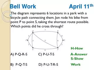
Coastal Work Group Meeting April 11, 2001. BLM. ACWI. NOAA. CA. USGS. FGDC. NSGIC. USFS. Subcommittee on Spatial Water Data (FACA). FEMA. TVA. COE. NRCS. TX. AK. EPA. ASCE. NWS. Subcommittee on Spatial Water Data. Coastal Watersheds Work Group. Guidelines Work Group.

E N D
BLM ACWI NOAA CA USGS FGDC NSGIC USFS Subcommittee on Spatial Water Data (FACA) FEMA TVA COE NRCS TX AK EPA ASCE NWS
Subcommittee on Spatial Water Data Coastal Watersheds Work Group Guidelines Work Group FGDC HUC Interagency Guideline
SUBCOMMITTEE Guidelines Workgroup Meeting, April 10&11, 2000
Hydrologic Units 2-digit= 1st level = 22 regions 4-digit= 2nd level = 222 subregions 6-digit= 3rd level = 789 accounting 8-digit= 4th level = 2223 cataloging new! 10-digit= 5th level = ~22,000 watersheds 12-digit= 6th level = ~160,000 subwatersheds
HUC History • WRC 1960’s • Hydrologic Units 1970’s • NRCS pioneer late 80’s & early 90’s • USGS, BLM, USFS review • Subcommittee 2000 • Many agencies helping to build high resolution datasets
focus: Integration of key Spatial Water Datasets • National Hydrography Dataset (NHD) • Watershed Boundary Dataset (WBD) • National Elevation Dataset (NED) • Hydrologic Derivatives(NED-H)
Partnering Agencies No one agency can do this by themselves! • NRCS • USGS • USFS • NWS • EPA • State & Regional Agencies • Water Resource Consortium
Methods / Approachesto delineating watersheds/subwatersheds • manual • semi-automated (NED/NED-H) • QA, delineate some/many HUCs
MANUAL vs AUTOMATED Interior of U.S. is getting done don’t know manual automated
NED National Elevation Dataset
5000pixels 2 sq.miles!
coastal delineation Options?
Carto- based options
coastline dependant “land limited”
coastline independent “sphere of influence”
coastline independent “whole island approach”
Geologic process Based options
NOAA/NOS Implementation • Pilots • Coastal delineation guidance • state/coast implementation • Assisting state groups • Workshops • Data and data manipulation • One-on-one with States
Issues to be resolved • Coastline – can watersheds be independent of coastline? • Estuarine systems – no clear hydrologic controls of flow. • Deltaic coastlines – streams do not converge to a point. • Barrier Islands – are they their own hydrologic unit or defined by area of influence? • Island Groups – (e.g. FL Keys, Pacific Islands, Aleutian, Tongas Nat. Forest)
Target Dates: • Jan’01 “draft” Unified Guideline into Subcommittee and FGDC review • “place holder” in Unified Guideline • Sept’01 “coastal guideline” addendum into review • Sept’01 submission as FGDC Standard Guideline
For additional information visit... water.usgs.gov/wicp www.fgdc.gov www.ftw.nrcs.usda.gov http://www.ftw.nrcs.usda.gov/huc_data.html rrpierce@usgs.gov