Download
1 / 34
410 likes | 598 Views
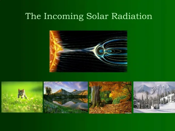
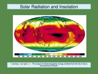
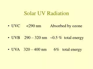
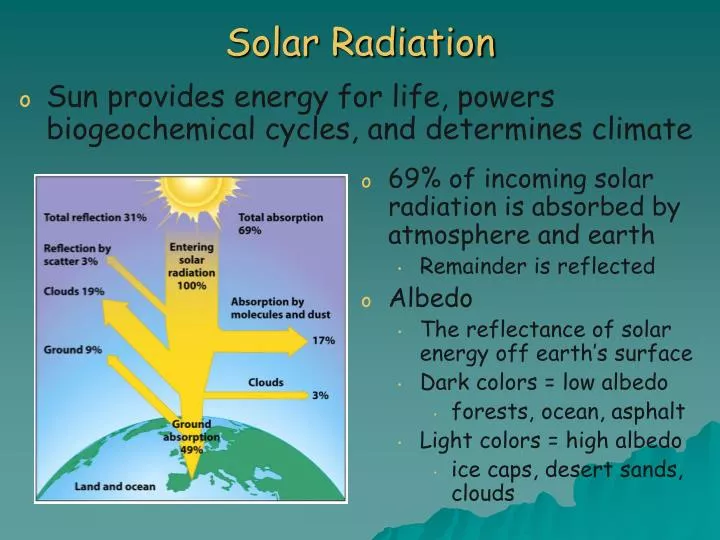
Solar Radiation. Sun provides energy for life, powers biogeochemical cycles, and determines climate. 69% of incoming solar radiation is absorbed by atmosphere and earth Remainder is reflected Albedo The reflectance of solar energy off earth’s surface Dark colors = low albedo

E N D
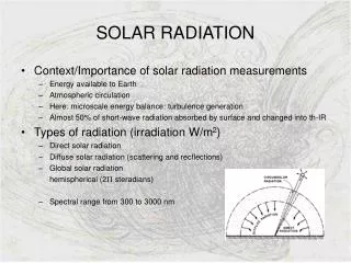
Solar Radiation • Sun provides energy for life, powers biogeochemical cycles, and determines climate • 69% of incoming solar radiation is absorbed by atmosphere and earth • Remainder is reflected • Albedo • The reflectance of solar energy off earth’s surface • Dark colors = low albedo • forests, ocean, asphalt • Light colors = high albedo • ice caps, desert sands, clouds
4 way Solar Radiation makes life on earth possible • warming the planet to a habitable temp • powers the biogeochemical cycles • allows producers to photosynthesize and feed other living organisms • stored in fuels – wood, oil, coal, nat’l gas
Temperature Changes with Latitude • Solar energy does not hit earth uniformly • Due to earth’s spherical shape and tilt Equator (a) High concentration Little Reflection High Temperature Closer to Poles (c) Low concentration Higher Reflection Low Temperature From (a) to (c) In diagram below
Temperature Changes with Season • Seasons caused by earth’s tilt (23.5°) • Causes each hemisphere to tilt toward the sun for half the year • Hem. Tilted toward sun receives more direct solar radiation & warmer temps. • Northern Hemisphere tilts towards the sun from March 21- September 22 (warm season)
Seasons • Hem. tilted toward sun rec. more direct solar radiation • Northern Hemisphere • Summer Solstice – Earth tilts toward sun • First day of Summer • June 21 or 22 • Autumnal Equinox – Earth along side sun • First day of Fall • Sept 21 or 22 • Winter Solstice – Earth tilts away from sun • First day of Winter • Dec 21 or 22 • Vernal Equinox – Earth along side sun • First day of Spring • Mar 21 or 22
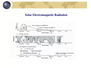
The Atmosphere • Invisible layer of gases that envelopes earth • Content • 21% Oxygen • 78% Nitrogen • 1% Argon, Carbon Dioxide, Neon and Helium, … • Density decreases with distance from earth • Shields earth from high energy radiation
Atmospheric Layers • Troposphere (0-10km) • where we live • where weather occurs • temp decreases with altitude • Stratosphere (10-45km) • temp increases with altitude • very stable • Ozone layer absorbs UV • Mesosphere (45-80km) • temp decreases with altitude • down to -138oC, -216oF
Atmospheric Layers • Thermosphere (80-500km) • gases in thin air absorb x-rays and short-wave UV radiation = very hot, 1000oC, 1832oF • source of aurora • Exosphere (500km and up) • outermost layer • no distinct boundary between it and outer space • just continues to thin
Atmospheric Circulation Moves heat from equator to the poles • Warm air rises, cools and splits to flow towards the poles • ~30° N & S sinks back to surface • air hits surface and splits to flow N & S • air warms and rises again at ~60° N & S • air sinks at poles
Heat is transferred throughout atmosphere in 3 ways • Radiation • heat energy transferred in the form of rays or waves • land and water absorb heat • Conduction • heat energy transferred through direct contact • air above land is in direct contact with land • *heat is always transferred from warmer to cooler • Convection • heat energy transferred through the flow of a fluid (liquid or gas) • warm air rises because less dense • cool air sinks because more dense
Surface Winds • Large winds due in part to high and low pressures caused by global circulation of air • Winds blow from high to low pressure • Little wind at latitudes of 0, 30, 60 & 90 because air rising or sinking High Low High Low High Low High
Prevailing Winds Winds are named for the direction FROM WHICH they move • Polar Easterlies • blow from East to West • Between 90o and 60o N or S • Prevailing Westerlies • blow from West to East • Between 30o and 60o N or S • Trade Winds • blow from East to West • Between 0o and 30o N or S Which of these are “our“ winds? Prevailing Westerlies
Global Ocean Circulation • Prevailing winds produce ocean currents and generate gyres • Example: the North Atlantic Ocean • Trade winds blow west • Westerlies blow east (these are our winds) • Creates a clockwise gyre in the North Atlantic • Circular pattern influenced by coriolis effect
Coriolis Effect • Earth’s rotation influences direction of wind • Earth rotates from East to West • Deflects wind from straight-line path • Coriolis Effect • Influence of the earth’s rotation on movement of air and fluids • Turns them Right in the Northern Hemisphere • Turns them Left in the Southern Hemisphere • chalk board globe
Coriolis Effect • Visualize it as a Merry-Go-Round (see below)
Global Ocean Circulation Westerlies Trade winds
Position of Landmasses Large landmasses in the Northern Hemisphere dictate ocean currents and flow Very little land in the Southern Hemisphere
Ocean Interaction with Atmosphere- ENSO • El Niño-Southern Oscillation (ENSO) • Def: periodic large scale warming of surface waters of tropical eastern Pacific Ocean • Alters ocean and atmospheric circulation patterns • Normal conditions- westward blowing tradewinds keep warmest water in western Pacific • ENSO conditions- trade winds weaken and warm water expands eastward to South America • Big effect on fishing industry off South America
Weather and Climate • Weather • conditions in the atmosphere at a given place and time • temperature, precipitation, cloudiness, etc. • Climate • average weather conditions that occur in a place over a period of years • 2 most important factors: temperature and precipitation • Earth as many climates
Rain Shadows • Mountains force humid air to rise • Air cools with altitude, clouds form and precipitation occurs (windward side) • Dry air mass moves down opposite leeward side of mountain
Tornadoes • Powerful funnel of air associated with a severe thunderstorm • Formation • Mass of cool dry air collides with warm humid air • Produces a strong updraft of spinning air under a cloud • Spinning funnel becomes tornado when it descends from cloud • Wind velocity= up to 300mph • Width ranges from 1m to 3.2km
Hurricanes / Tropical Cyclone • Giant rotating tropical storms • Wind >119km per hour • Formation • Strong winds pick up moisture over warm surface waters • Starts to spin due to Earth’s rotation • Spin causes upward spiral of clouds • Damage on land • High winds • Storm surges
Internal Planetary Processes • Layers of the earth • Crust (oceanic & continental), mantle, core • Lithosphere – crust + upper mantle • rigid rock layer • tectonic plates • Asthenosphere – lower mantle • molten • Plate Tectonics - study of the processes by which the lithospheric plates move over the asthenosphere
Plate Boundary- where 2 plates meet • 3 types • convergent– plates moving toward each other • volcanoes & EQ • divergent- plates moving away from each other • mid-ocean ridges, volcanic activity • transform– plates sliding/grinding past each • earthquakes Mantle Convection • Causes plate movement • Convection currents in asthenosphere move beneath lithosphere and drag plates along
Types of Plate Boundaries Convergent Plate Boundary: plates move toward each other • oceanic-continental crust = subduction of oceanic plate (as shown) • Examples: • Andes Mountains • Cascade Range in Oregon and Washington state – Mt. Saint Helen’s • continental-continental = no subduction; HUGE mountain ranges • Examples: • Himalayas, Apalachian Mountains
Types of Plate Boundaries Divergent Plate Boundary: plates move away from one another Examples: Mid-Atlantic Ridge
Types of Plate Boundaries • Transform Plate Boundary: plates move horizontally in opposite, parallel directions • Examples: • San Andres Fault, CA
Earthquakes • Caused by the release of accumulated energy as rocks in the lithosphere suddenly shift or break • Occur along faults • Energy released as seismic wave • Focus- where earthquake originates below the surface • Epicenter- located on the earth’s surface, directly above the focus • Richter scale and the moment magnitude scales are used to measure the magnitude
Tsunami • Giant undersea wave caused by an earthquake, volcanic eruption or landslide • Travel > 450mph • Tsunami wave may be 1m deep in ocean • Becomes 30.5m high on shore • Magnitude 9.3 earthquake in Indian Ocean • Triggered tsunami that killed over 230,000 people in South Asia and Africa