Download
1 / 21
340 likes | 922 Views
Ocean Systems Part 2: Surface Currents.

E N D
Ocean SystemsPart 2: Surface Currents Much of the work that follows is straight from (or slightly modified) notes kindly made available by Jenny Pollock NCG and or spk (?)…. Nice to have a collaborative culture in NZ schools. My apologies to other folk who’s work I have used without acknowledgement or permission… sorry about that, knick something of mine to even things up
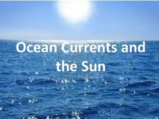
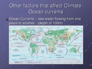
How surface currents are formed • 10% of the ocean flows in surface currents. These are like rivers in the ocean, with water flowing horizontally in the upper 400 metres. • Four forces drive the ocean’s currents: • The Sun’s heat • Surface winds • The Coriolis effect • Wind friction • These act together to form currents which circulate clockwise in the Northern Hemisphere and anti-clockwise in the Southern Hemisphere.
The heating effect of the Sun The sun warms the Earth's surface and the atmosphere. Some areas receive direct sun rays all year and are always warm, like the equator. Other places receive indirect rays, and so are colder. Warm air rises, becoming less dense. More dense cool air moves in and replaces the rising warm air. This makes the wind blow.
The heating effect of the Sun The area between the Tropic of Cancer and the Tropic of Capricorn receive direct sun rays all year round. These parts are warm all the time and so the air above is warm. North and South of the tropics receive indirect rays, so the air is cooler. Light, warm air rises from the equator and the tropics. Then cool air moves towards the equator and replaces the rising warm air. This movement of air is what makes the trade winds blow.
Surface winds Winds, driven by uneven solar heating and the Earth’s spin (Coriolis effect) drive the movement of the ocean’s surface. The prime movers are the easterly trades and the powerful westerlies
The Coriolis effect The Coriolis effect is the apparent deflection of objects (such as airplanes, wind, missiles, and ocean currents) moving in a straight path relative to Earth's surface. It’s stronger at the equator and weakest at the poles.
The Coriolis effect An airplane takes off from the North Pole, and flies in a straight line toward the equator. During the flight, Earth slowly rotates, so the path of the airplane from the ground would look like it had curved. The plane looks like it flew to the west, or right as Earth rotated. If you were watching Earth's surface from a fixed spot in outer space, you would see the plane move in a straight path, and Earth rotate underneath. In the southern hemisphere the deflection is to the left
The Coriolis effect - more The spin of the Earth makes the trade winds curve towards the west, as shown in the diagram. In the Southern hemisphere these winds are called the south east trade winds because that is where the winds come from. In the Northern hemisphere the north east trade winds come from the north east direction.
Wind Friction Friction between the wind and the water surface causes the water to move. Some of the energy of the wind is transferred to the water to make waves and some is transferred to create surface currents.
The Earth’s spin means that the surface currents circulate in giant loops called gyres.Ocean basins affect the direction of flow too
Major surface currents http://www.eng.warwick.ac.uk/staff/gpk/Teaching-undergrad/es427/rice.glacier.edu-oceans/GLACIER%20Oceans-%20--%20Windcirculation.htm Water flows around ocean basins.Gyres can be subdivided into distinct currents: transverse currents, eastern boundary currents, and western boundary currents.
Transverse currents Transverse currents flow east-west. In the equatorial ocean, much of the surface water is caught up in the North and South Equatorial Currents. These transverse currents flow from east to west along each side of the equator and are driven primarily by the easterly trade winds. The West wind drift is the Antarctic Circumpolar current.
Counter currents http://asramp10.blogspot.co.nz/2010/04/questions-pertaining-to-oceanograph-of.html Countercurrentsare another type of transverse current. The subtropical gyres in each hemisphere are separated by narrow eastward-flowing equatorial countercurrents flowing opposite to the equatorial currents. Countercurrentsthat flow below the surface are called undercurrents. The Pacific Equatorial Current EUC, flows to the east along the equator at a depth of about 100 m.
West Boundary currents Western boundary currents are deep and fast moving and are among the largest and strongest ocean currents. They occur at the western side of an ocean basin and carry water and therefore heat from the equator towards the poles. So they also help moderate our climate.
Eastern Boundary currents Eastern boundary currents transport water from the pole to the equator. They are the return flow from the western boundary currents as they are driven back across the ocean by westerly winds. They occur on the eastern side of the basin, and are shallower, more broad, and slower than western boundary currents.
There are massive floating garbage patches in the Pacific Ocean. They are killing marine life and releasing poisons that enter the human food chain. One plastic patch is estimated to weigh over 3 million tons and covers an area nearly the size of Australia. ……Caused by? But is this realistic? (click here)This would be a good topic for an exam question I reckon
Our neighbourhood Guess where crayfish larvae accumulate after their year long drift in the plankton
Ekman spiral (northern Hemisphere) www4.ncsu.edu paoc.mit.edu
Pressure in the ocean • At sea level, the air presses down on our bodies at 1 atmosphere or 1kg per 1 square cm. You don't feel it because the fluids in your body are pushing outward with the same force. • In the ocean, pressure increases with depth. For every 10 metres the pressure increases by 1 atmosphere. • In the deepest ocean, the pressure is equivalent to the weight of an elephant balanced on a postage stamp….. Be a bit squishy down deep then I guess