Download
1 / 1
10 likes | 144 Views
Fire Weather Research Laboratory. San José State University. Observed Kinematic Structure of a Fire Plume Using Ground-Based Remote Sensing Instrumentation. Allison M. Charland and Craig B. Clements Department of Meteorology and Climate Science, San José State University, San José, CA, USA

E N D
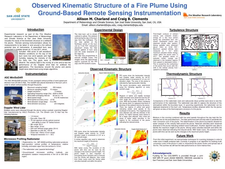
Fire Weather Research Laboratory San José State University Observed Kinematic Structure of a Fire Plume Using Ground-Based Remote Sensing Instrumentation Allison M. Charland and Craig B. Clements Department of Meteorology and Climate Science, San José State University, San José, CA, USA Email: allison.charland@sjsu.edu; craig.clements@sjsu.edu z x Introduction Experimental Design Turbulence Structure Ignition Time-height contours of vertical velocity and turbulent kinetic energy for a two hour period during the prescribed burn are shown. Downward motion was observed shortly after ignition. Strong updrafts were observed above 100m at 12:20 PST.Maximum upward velocity was measured at 1 ms-1 while maximum turbulent kinetic energy values within the plume were 3 m2s-2. The greatest values of turbulent kinetic energy are observed in the transition regions from upward to downward motion. This is caused by the overturning of the plume that occurs with the shift in the vertical velocity from upward to downward. Experimental research as part of the Fire Weather Research Laboratory in the Department of Meteorology and Climate Science at San Jose State University includes the study of the kinematic structure of a wildland fire plume. Remote sensing instrumentation allows for measurements to be taken in and around a fire without potential loss of instruments. A prescribed burn was conducted in complex terrain on 13 July 2011, which The total burn unit is shown outlined in yellow. The ambient wind during the day of the burn was from the northwest. The fire was ignited at the Northeast corner of the burn unit at 11:43 PST. Instrument placement shows the lidar placed upwind of burn area and the sodar downwind on the ridge top. The lidar was programmed to execute multiple scans. The images show the approximate regions scanned by the PPI (top) and RHI (bottom) scans. included ~660 acres of oak woodland.Weather conditions on the day of the burn were low wind speeds and high humidity, keeping the intensity of the fire fairly low. The goals were to observe thevelocity field in the vicinity of a fire and to test the performance of the Doppler wind lidar for wildland fire applications. The boundaries around the plume and plume height were determined using simple algorithms. Observed Kinematic Structure Instrumentation Thermodynamic Structure Doppler Radial Velocity (ms-1) Backscatter Intensity PPI scans show the backscatter intensity and Doppler radial velocity for 30-70o azimuth angle in increments of 1.0o at a 10o elevation angle. The area of the plume is indicated by high backscatter intensity. The plume boundaries were determined using the following algorithm at every azimuth angle: Regions of lighter and slightly reversed radial velocities were observed near the 30o scan angle due to the geometry of the scan. With the boundary shown overlaying the velocity field, it is apparent that there is blocking of the ambient wind by the plume. There are regions of yellow and green indicating slower wind speeds to the southeast of the plume. The magnitude and area affected vary with the intensity of the plume. For higher intensity, there seems to be a larger area affected. Also noted are areas of faster radial velocities in the regions to the southwest of the plume indicating fire induced winds. 13 July 2011 0900 PST ASC MiniSoDAR 13 July 2011 1149 PST The ASC MiniSoDAR provides 10-min averaged vertical profiles of wind speed and direction from 20-200 m AGL. The SoDAR was placed downwind of the burn unit in order to obtain vertical profiles through the plume. • Maximum sampling height: 250 meters • Minimum sampling height: 15 meters • Height resolution: 5 meters • Operating frequency range (Hz): 4500 to 5500 • Wind table averaging interval: 30 sec to 1 hr • Wind speed range: 0 to 50 meters/sec • Wind speed accuracy (m/s): <0.50 • Wind direction range (deg): 0 to 359 • Wind direction accuracy: ±5.0 degrees Comparisons of the radiometer (red) and radiosonde (blue) profiles were done to test the performance of the radiometer. The radiometer was able to capture the structure of the atmosphere within the boundary layer. In upcoming experiments, the radiometer can be deployed downwind of the burn unit. Temperature profiles obtained within the fire plume will given an idea of the thermodynamic structure of a fire plume. Doppler Wind Lidar • Multiple scans were obtained through the plume using a pulsed, scanning Doppler lidar manufactured by HALO Photonics, Ltd. The Stream Line 75 lidar has the following features: • 1.5 micron • Eye safe, Class 1M • 75 mm aperture all-sky optical scanner • with ability to scan 15° below horizon • Min range: 80 m • Max range: 10 km • 550 user defined range gates (24 m) • Operates on 24V DC, 150 W • Pulse rate: 15kHz (10 km range) • Temporal resolution: 0.1 – 30 s Results • Moisture in the morning combined with low wind speeds throughout the day kept the fire intensity low for the prescribed burn. The lidar performed well and was able to penetrate the main convection core of the plume. The determination of the plume boundaries allowed for easier analysis of the velocity field around the plume. Reduced velocities were observed downwind of the plume indicating ambient wind modification. Another algorithm was able to identify the maximum height of the plume. Strong radial velocities beneath and within the plume were observed indicating fire-induced winds. With faster scans, the evolution of the plume with time can be seen by the changes in the maximum plume height. Backscatter Intensity Doppler Radial Velocity (ms-1) RHI scans show the backscatter intensity and Doppler radial velocity for 7.5-45o elevation angle in increments of 2.5o at a 95o azimuth angle. A similar algorithm was used to determine the maximum height of the plume: With faster scans, the evolution of the plume with time can be seen by the changes in the maximum plume height. The plume height is also important for forecasting plume transport and to forecast how the smoke will disperse. Also noted from these scans were the strong radial velocities beneath and within the plume. Future Work Microwave Profiling Radiometer • From this initial experiment, we learned better techniques for scanning strategies in order to make more in-depth analyses later. Currently in progress is an algorithm for tracking multi-convection cores of the plume in order to characterize the plume motion and spread rate of the fire. This summer we will test the lidar performance on more intense fires. • Radiometrics, Inc., MP-3000A profiling radiometer produces high-resolution vertical profiles of temperature, relative humidity, and water vapor from the surface to 10 km. • The radiometer uses “passive technology” • Ground-based microwave profiling methods use atmospheric radiation measurements in the 20 to 200 GHz region. Acknowledgements Funding for the CSU-MAPS is provided through a joint NSF-MRI R2 grant (AGS# 0960300, 0960348) awarded to San Francisco and San José State Universities.