Download
1 / 27
290 likes | 478 Views
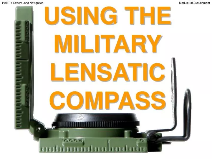
PART 4 Expert Land Navigation. USING THE MILITARY LENSATIC COMPASS. Module 20 Sustainment. PART 4 Expert Land Navigation. Module 20 Sustainment. WARNING.

E N D
PART 4 Expert Land Navigation USING THE MILITARY LENSATIC COMPASS Module 20 Sustainment
PART 4 Expert Land Navigation Module 20 Sustainment WARNING This presentation is intended as a quick summary, and not a comprehensive resource. If you want to learn Land Navigation in detail, either buy a book; or get someone, who has the knowledge and skills, to teach you in person.
PART 4 Expert Land Navigation Module 20 Sustainment NOTE To get the ideas across presented on these slides, many figures, pictures, and calculations may not be to scale and may be exaggerated for clarity.
PART 4 Expert Land Navigation Module 20 Sustainment Note: Prior to being issued any training *equipment, you will be required to sign a “statement of liability” agreeing to pay for anything you damage or lose. All items will be inspected and inventoried prior to your signature and at the end of the training day too. If you do not intend to sign this statement, then you may be denied training. *You may use your own equipment.
PART 4 Expert Land Navigation Module 20 Sustainment Any Questions?
PART 4 Expert Land Navigation Module 20 Sustainment LAND NAVIGATIONPRESENTATIONPART 4Module 20Sustainment
PART 4 Expert Land Navigation Module 20 Sustainment . . . and now on with the . . . PRESENTATION
PART 4 Expert Land Navigation Module 20 Sustainment LAND NAVIGATION WITH MAP ANDLENSATIC COMPASS
PART 4 Expert Land Navigation Module 20 Sustainment LAND NAVIGATION • Why Learn Land Navigation? • Tracking present location • Determining Distance • Sense of direction • How to read a topographic map • Terrain and map association • Spatial skills • Planning safe, practical routes • And more Navigational skills • The best way to learnLAND NAVIGATION is to get "dirt time", that is, get out there with a map and compass! • Navigation is not about finding yourself after you are lost (although that’s what happens sometimes); it’s about keeping track of your position as you move away from a known point. As you move you have to remain cognizant of the terrain you are leaving, of the terrain you are passing, and of the terrain that is ahead. • Navigation in the wilderness means knowing your starting point, your destination, and your route to get there. • These skills will allow you to venture farther off the beaten path than you ever thought before. Training and practicing land navigation on foot provides the following everyday navigation (how not to get lost) benefits; (Where am I?) (How far is it and am I there yet ?) (Where do I want to go and where am I actually going ?) (Do I understand the map ?) (What hill or river am I looking at ?) (Can I mentally visualize the landscape in 3D ?) (Take a long safe route or a short risky route ?)
PART 4 Expert Land Navigation Module 20 Sustainment • THIS PRESENTATION IS DIVIDED INTO FOUR PARTS • ________________________________________________________________________________________________________________________________________________________ • PART 1 Basic Land Navigation • The Lensatic Compass module 1 • The Topographic Map modules 2, 3, 4, • The Land and Map Association modules 5, 6 • PART 2 Intermediate Land Navigation • Making Sense of Direction module 7 • Tracking Present Location modules 8, 9, 10, 11 • Determining Travel Distance modules 12, 13, 14 • PART 3 Advance Land Navigation • Navigation Methods to Stay On Course module 15 • Additional Skills of Land Navigation module 16 • Planning to Navigate module 17 • PART 4 Expert Land Navigation • Navigation in different types of Terrain module 18 • Night Navigation module 19 • Sustainment module 20
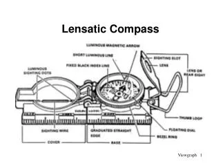
PART 4 Expert Land Navigation Module 20 Sustainment THESE ARE THE TRAINING MODULES Module 1 Lensatic Compass – parts and features, and how to sight the compass by two different methods. Module 2 Topo Map Margin – what map margin data represents, map care, and how to properly fold a map. Module 3 Topo Map Scale – map sizes and how it affects amount of detail that will be shown. Module 4 Topo Map Symbols – you must understand them; to read and speak map language to others. Module 5 Terrain Relief – shows elevation, indicates terrain features and heights of natural features. Module 6 Map Information – what a protractor is for and how a map provides four kinds of information. Module 7 Sense of Direction – lateral drift, current bearing, obstacles, back azimuth, deliberate offset. Module 8 Resection – locate position with map only. Modified resection is with a map or compass. Module 9 Intersection & Triangulation – two methods to locate position by compass. Module 10 Map Speaks Compass Language - there is no need to orient the map to find your position. Module 11 Plotting Position Coordinates – exact positioning, used to communicate to others with a map. Module 12 Route Measure – mapping straight-line distance, curvature distance, and slope distance. Module 13 Pace Count – using ranger pacing beads and estimating hiking speed. Module 14 Travel Distance Estimation – estimating by 100 meter rule, rule-of-thumb, and by time. Module 15 Plan to Navigate – in a group or alone, equipment, safety, responsibilities, route selection. Module 16 Stay on Course – advance reference points and advance baselines. Module 17 Additional Land Navigation Skills – estimate daylight, conserve energy, blisters, weather insight. Module 18 Navigating Different Terrain – special environments, featureless terrain, visibility, dense foilage. Module 19 Night Navigation – night adaptation, protecting night vision, navigate with lensatic compass. Module 20 Sustainment – maintaining skills, training others, setting up a land navigation course.
PART 4 Expert Land Navigation Module 20 Sustainment Any Questions?
PART 4 Expert Land Navigation Module 20 Sustainment PART 4EXPERT LAND NAVIGATION MODULE 20 • Sustainment • Description • Maintaining Skills
PART 4 Expert Land Navigation Module 20 Sustainment SUSTIANMENTDESCRIPTION Land navigation is a skill that is highly perishable. The Navigator must continually make use of the skills they have acquired to remain proficient in them. Sustainment should use the building-block approach to training; theory of land navigation; the practice of these skills; land navigation testing, and building of navigation skills. The purpose of setting up a sustainment program is to provide Navigators with training that reinforces and builds on the training they have received in the classroom and field. All Navigators should receive this training at least twice a year. The program also provides the Navigator with a means of identifying the areas in which the they need additional training. • The best way to maintain yourLAND NAVIGATION skills is to get "dirt time", that is, get out there with a map • and compass! • SUSTAINMENT PROGRAM • TRAIN-THE-TRAINER PROGRAM • SET UP A LAND NAVIGATION COURSE
PART 4 Expert Land Navigation Module 20 Sustainment SUSTIANMENTSUSTAINMENT PROGRAM The sustainment program should address all skills from basic map reading to the Navigator planning and executing a route. • The program should cover the following: • Map reading instruction/review. • Land navigation skills training. • Dead reckoning training/practice. • Terrain association training/practice. • Land navigation written/field examination. • Training and testing. • The program should be developed into individual “Training Modules” so that it can be used as a whole group program or used separately by individuals. • First determine the levels of proficiency and problems that the Navigators have in land navigation. • Evaluate by personal observation, written test, and annual training. • Provide training site, resources, and time for Navigators to practice land navigation.
PART 4 Expert Land Navigation Module 20 Sustainment Any Questions?
PART 4 Expert Land Navigation Module 20 Sustainment SUSTIANMENTTRAIN-THE-TRAINER ROGRAM The purpose of a Train-the-Trainer program in a group is to develop instructors that are capable of training navigators with the confidence and skills necessary to accomplish all assigned land navigation tasks. Development of the Program. The group should appoint a cadre of instructors to act as primary and alternate instructors for land navigation training. Determine which instructors conduct which module of training and have them practice until they are fully prepared to give the training. These instructors act as training cadre for the entire group. They train their peer instructors to instruct the subordinate members, and they certify each instructor’s training program. Use the training modules the group has developed and have the students go through each module of training until they can demonstrate expertise. Conduct of Training. Conduct training at the lowest level possible.
PART 4 Expert Land Navigation Module 20 Sustainment Any Questions?
PART 4 Expert Land Navigation Module 20 Sustainment SUSTIANMENTSET UP A LAND NAVIGATION COURSE • There are basic guidelines to use when setting up a course. • Determine the Standards. The group determines the standards for the course. Recommended standards are as follows: • A course is made up of routes (lanes) - no less than 3 lanes, no more than 5 lanes. • • Total distance of a lane - no less than 2,700 meters, no more than 11,000 meters. • • Total number of position stakes (legs) for each lane - no less than 7, no more than 9. • • Distance between stakes - no less than 300 meters, no more than 1,200 meters. • • Time allowed - no less than three hours, no more than four hours. • Decide on the Terrain. The group should use terrain that is similar to terrain they will be using in actual expeditions / wilderness trips, but, terrain should be different each time training is conducted. • The training area for a course needs to be at least 25 square kilometers (5Km x 5Km). • Perform a Map and Ground Reconnaissance. Check the terrain to determine position stake locations, to look for hazards, and to develop training briefings. • The following sequence can be used to develop any type of land navigation course. The difference in each course depends on the groups guidance. • (1) Plot the locations of your position stakes on a map. • (2) Fabricate position stakes. (what type of material to use – easily visible from a far distance or less visible) • (3) Survey the locations of your position stakes. • (4) Certify the course by having your subject matter experts (SMEs) negotiate each lane of the course. • (5) Prepare course requirement sheets and print them. • (6) Complete a risk assessment of the training area. • (7) Begin teaching.
PART 4 Expert Land Navigation Module 20 Sustainment SUSTIANMENTSET UP A LAND NAVIGATION COURSE There are basic guidelines to use when setting up a course. STANDARDS: The candidate must navigate using the compass from a start point, through several intermediate points (stake points), to a finish point, and record the position stake number for each point within 4 hours. the following information must be annotated for record purposes: • Start time. • From start point to point 1: degrees magnetic, meters, and position stake number. • From point 1 to point 2: degrees magnetic, meters, and position stake number. • From point 2 to point 3, etc, to finish point: degrees magnetic, meters, and position stake number. • Stop time and elapsed time in hours and minutes.
PART 4 Expert Land Navigation Module 20 Sustainment = Stake Points (which may or may not be shown on the student’s map depending on skill level) SP8 SP9 SP7 SP6 SP5 SP4 SP3 SP1 SP2 FINISH 1 ½ 1 0 KM SUSTIANMENTSET UP A LAND NAVIGATION COURSE EXAMPLE #1 SETTING UP A COURSE. Navigator Atraining lane #1 – Proceed to SP1, SP5, SP4, SP2, SP7, SP6, SP8, FINISH Point Navigator B training lane #2 – Proceed to SP3, SP8, SP6, SP1, SP2, SP4, SP5, FINISH Point Navigator C training lane #3 – Proceed to SP9, SP3, SP5, SP1, SP2, SP4, SP1, FINISH Point THIS IS HOW EACH NAVIGATOR SHOULD FINISH ON THEIR ANSWER SHEET Navigator A SP1 (250º / 400m / 15min) SP5 (169º / 1050m / 47min) SP4 (055º / 1000m / 30min) SP2 (337º / 400m / 15min) SP7 (107º / 450m / 23min) SP6 (325º / 600m / 35min) SP8 (267º / 1400m / 1hr 28min) FINISH (115º / 1100m / 1hr 5min) Navigator B Same process above. Navigator C Same process above. A B C ROAD
PART 4 Expert Land Navigation Module 20 Sustainment = Stake Points (which may or may not be shown on the student’s map depending on skill level) SP8 SP9 SP7 SP6 SP5 SP4 SP3 SP1 SP2 FINISH C FINISH B FINISH A 1 ½ 1 0 KM SUSTIANMENTSET UP A LAND NAVIGATION COURSE EXAMPLE #2 SETTING UP A COURSE. Navigator Atraining lane #1 – Proceed 235º 500m, 112º 1300m, 352º 800m, 230º 1800m Navigator B training lane #2 – Proceed 287º 350m, 104º 1300m, 330º 850m, 220º 1650m Navigator C training lane #3 – Proceed 046º 700m, 108º 1400m, 331º 850m, 232º 1850m THIS IS HOW EACH NAVIGATOR SHOULD FINISH ON THEIR ANSWER SHEET Navigator ASP2, SP6, SP9, FB Navigator B SP3, SP5, SP7, FC Navigator C SP1, SP4, SP8, FA IF THE NAVIGATOR HAS A DIFFERENT ANSWER, THIS IS WHERE THEY MADE ERRORS IN CALCULATING THEIR “POSITION” AND LAND NAVIGATION “STAYING ON COURSE”. EXAMPLE Navigator A reached SP1 vice of SP2. From there, SP4, SP9, FA (Navigator drifts to the right). A B C ROAD
PART 4 Expert Land Navigation Module 20 Sustainment = Stake Points (which may or may not be shown on the student’s map depending on skill level) SP9 SP2 SP1 SP3 SP4 SP5 SP6 SP7 SP8 FINISH B FINISH A FINISH C SUSTIANMENTSET UP A LAND NAVIGATION COURSE EXAMPLE #3 SETTING UP A COURSE. Navigator Atraining lane #1 – UTM Coordinates 55906 428261, 56073 428194, 56059 428307, 55866 428171 Navigator B training lane #2 – UTM Coordinates 55906 428248, 56084 428205, 56025 428307, 55880 428158 Navigator C training lane #3 – UTM Coordinates 55906 428274, 56095 428213, 56040 428307, 55852 428186 THIS IS HOW EACH NAVIGATOR SHOULD FINISH ON THEIR ANSWER SHEET Navigator ASP2, SP6, SP9, FB Navigator B SP3, SP5, SP7, FC Navigator C SP1, SP4, SP8, FA IF THE NAVIGATOR HAS A DIFFERENT ANSWER, THIS IS WHERE THEY MADE ERRORS IN CALCULATING THEIR “POSITION” AND LAND NAVIGATION “STAYING ON COURSE”. EXAMPLE Navigator A reached SP1 vice SP2. From there, SP4, SP9, FA (Navigator drifts to the right). 4283 A B C ROAD 4282 4281 558 560 561 559
PART 4 Expert Land Navigation Module 20 Sustainment Any Questions?
PART 4 Expert Land Navigation Module 20 Sustainment Note: Prior to being issued any training *equipment, you will be required to sign a “statement of liability” agreeing to pay for anything you damage or lose. All items will be inspected and inventoried prior to your signature and at the end of the training day too. If you do not intend to sign this statement, then you may be denied training. *You may use your own equipment.
PART 4 Expert Land Navigation Module 20 Sustainment TESTING Now it is time for the following . . . • Written exam • Hands-on / Outdoors exam
PART 4 Expert Land Navigation Module 20 Sustainment THE END OFLAND NAVIGATIONPRESENTATIONPART 4Module 20Sustainment