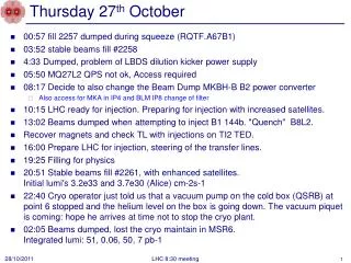
Download
1 / 18
180 likes | 329 Views
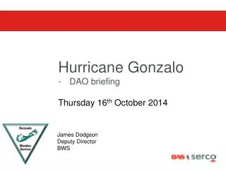
Hurricane Gonzalo EMO briefing Thursday 16 th October 2014. Kimberley Zuill Director BWS. Great example of eye wall replacement - Gonzalo. http://youtu.be/G0Nnlfr3WYw. Play until 3:40 min NOTE: this is a video from yesterday not today – right before increasing to Cat 4

E N D
Hurricane Gonzalo • EMO briefing Thursday 16th October 2014 Kimberley Zuill Director BWS
Great example of eye wall replacement - Gonzalo • http://youtu.be/G0Nnlfr3WYw • Play until 3:40 min • NOTE: • this is a video from yesterday not today – right before increasing to Cat 4 • this is for informational/educational purposes • Showing this due to Gonzalo possibly going through • eye wall replacement cycles again while over Bermuda.
06z Thursday Surface Analysis Bermuda Current Surface Map: http://www.weather.bm/maps/Atlantic.gif
ASCAT (Satellite-derived) Winds earlier today Hurricane Gonzalo Bermuda 20-25 knot winds Bahamas
Tropical Update Bulletin • Gonzalo forecast to be either a weak category 3 or strong category 2 as it passes so near to Bermuda that it • is still considered a direct hit
Forecast – Hurricane Warning Tides: High: Thur 3:38pm Fri 4.13am (CPA) 4:51pm Sat 5:17am 5:47pm Low: Thur 10:09pm Fri 10:30am 11:01pm Sat 11:27am 11:50 pm
Data from NOAA buoy 41046- 554 nm SSW of Bermuda • Hurricane Gonzalo passed directly over the buoy about 6pm last night • (Wed. Oct 15) • Wave heights almost 35 feet • This gives high confidence in the sea forecast
Tide times – St Georges CPA 5pm = high tide
Onset/Cessation Wind Timings Tentative Wind Timings – based on 12pm Thurs 16 Oct, 2014 Midnight tonight – 6am Sat – 30hrs Onset: • Tropical Storm Force Winds (30hr) • Marine Area: Midnight tonight – 2 am • Island: 1-2 am tonight • 50 knot (SE) Winds (15hr) • Marine Area: Noon – 1pm Friday • Island: 1pm - 2pm Friday • Hurricane Force Winds (8-10hr) • Marine Area: 2pm - 3pm Friday • Island: 3pm-4pm Friday Cessation: • Hurricane Force Winds • Island: 11pm – midnight Friday • Marine Area: 1am – 2am Saturday • 50 knot Winds • Island: 1am – 2am Saturday • Marine Area: 3am – 4am Saturday • Tropical Storm Force: • Island: 4am Saturday • Marine Area: 6am Saturday 35-40ft seas with Heavy damaging Swell & Surge 30% higher Wind speed if elevated & Windward
Conclusion • Direct hit as Cat 3 downgrading to Cat 2 – note possible eye wall replacement & shift of winds & eye wall convection • Slowed down slightly and nudged towards BDA = longer duration of hurricane force winds (6-8hrs) & a few hours later than yesterday’s forecast • Delay – unfortunately this lines up with high tide at 5pm with higher swells & seas – forecast increased to 35ft seas greatest impact East & South Shore - (note: cat 3 passage add ~ 10ft for surge) FABIAN – 6-8ft storm surge • 30% higher wind speeds in elevated and windward locations • Gonzalo is already a deadly major hurricane as one person has died in St. Maarten due to storm surge – STAY OUT & OFF OF THE WATER!!!! • This man was on his boat. Thank you for your attention, any Questions?
Hurricane Gonzalo – EMO & DAO brief BWS briefing- Thursday 16th October 2014 http://www.weather.bm\EMO\Gonzalo EMODAO brief Thurs/ NHC http://www.nhc.noaa.gov/ BWS http://www.weather.bm