Download
1 / 24

E N D
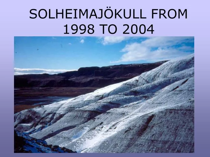
Solheimajökull is an outlet glacier from the Mýrdalsjökull ice cap. Under the ice cap is the volcano Katla which erupts explosively with a recurrence interval of about 100 years, although melting takes place most of the time because of gentle activity under the ice-cap. Mýrdalsjökull Katla’s crater is filled with glacier ice, but the outline can be seen clearly. Solheimajökull
These photos have been taken over a period of 6 years. They show how Solheimajökull has changed over that period. We can use them to make an estimate of how far the snout has retreated and how much the glacier has thinned. The glacier has a ridge of solid rock on its east side, so it is possible to walk above the ice and use features of the valley sides to compare the position of the ice in different years. Some photos are used for comparison and not because of the quality of the image. Thanks to many students for acting as scale.
Looking down the eastern side of Solheimajökull towards the snout. Although there was snow cover in the spring, it is easy to see that there has been very rapid recession during the summer, with the formation of many moraines. The circle marks the same position. Moraines formed during one summer of recession. March 1998 October 1998 Group for scale
This sequence shows changes in the snout position. A vegetated moraine close to the snout is ringed so that recession can be judged, though there is no scale that would allow measurement of recession. October 1999 snout
From this angle it is difficult to see how much snout recession has occurred. Note the change in the roughness of the glacier surface, especially the positions of the dirt cones. The proglacial streams are in very different courses compared with 1999. October 2000
Snout from ridge April 2004 The snout appears to have receded the distance shown by the arrow since October 2000, though the amount could not be measured from this photo. Photo of the snout taken from the ridge in April 2004. The snout appears to have receded a considerable distance, shown by the arrow, since October 2000, though the amount could not be measured from this photo.
A push moraine in 1998 very close to the glacier snout. The circled block on this moraine was still visible in April 2004. This is thought to be a push moraine because it has been pushed over existing vegetation. The existence of a push moraine shows that the snout had advanced in the 1990s, so the general pattern of recession of the snout position is sometimes interrupted.
The circled block on the push moraine was still visible in April 2004, although the moraine itself has been washed away by meltwater in the last 6 years and the glacier snout has retreated, probably by several hundred metres. The circled block on the push moraine was still visible in April 2004, although the moraine itself has been washed away by meltwater in the last 6 years and the glacier snout has retreated, probably by several hundred metres.
This photo shows the appearance of the snout in March 1998. The skyline enables comparison with the next photo.
In October 2000 the snout was a similar shape though the details of the surface and the crevasses are very different. Students near snout in October 2000
A small jökulhlaup (ice melted by a sub-glacial volcano) took place in July 1999, but lasted only 24 hours, as the volcano Katla, under the Mýrdalsjökull icecap, erupted. There had been sulphurous smells and many minor earth tremors beforehand. The snout was very black in October 1999 compared with March 1998, probably because some of the dirty water from the jökulhlaup moved upwards through crevasses on the ice and poured over the surface.
The channels in the outwash plains were formed by thejökulhlaup in July 1999, although the discharge was not great enough to damage the road or bridge. Snout in 2001 with jökulhlaup channels
Portal of the 1999 jökulhlaup river which flowed from Katla. We were able to walk inside the ice cave formed by the river as it emerged from under the ice. This channel would have been full of water during the 24 hours in which the jökulhlaup was at its greatest discharge. October 1999
The channels still exist in April 2004, though the slopes are much more gentle as river undercutting has ceased and slope processes modify the sides of the channels. Jökulhlaup channels Jökulhlaup channels April 2004 Jökulhlaup channels October 2000
Comparison of the snout positions in October 1999 and April 2004 It is clear that there has been considerable recession in five years.
East side of Solheimajökull looking up to the ridge in October 2001 ridge Exposed palagonite Dirty ice with dirt cones Lateral moraine The red circle marks solid rock in this photo and the next.
East side of Solheimajökull looking up to the ridge, in April 2004. There are few landmarks in the lateral moraine to show how much recession there has been since October 2001. However note the area marked by the square where there has been a lot of recession.
In the first few years of our visits we were unable to reach the lateral section of the glacier because the slopes down from the ridge were too steep. Each year the glacier sides retreat and leave a jumble of lateral moraine behind on the slopes of the solid ridge, which is made of palagonite with some basalt lavas flows. Lateral area towards ridge April 2004
Ring road and bridge over the glacial river Huge outwash terraces from previous floodplains March 1998 Outwash plain End moraines dating from C17th and C18th Looking across the outwash plain from the ridge ridge
Proglacial river March 1998 Proglacial river looking downstream March 1998 Proglacial river from the same position, looking upstream April 2004 The channel has changed position and does not now flow so close to the bank.
Views towards Mýrdalsjökull over a period of five yearsfrom the top of the ridge.There was a marked change in colour in earlier years, as the ice close to the land surface was very black, probably from the July 1999 jökulhlaup when dirty meltwater was forced up crevasses as it reached the end of the glacier and so discoloured the surface ice. Winter snowfall in later years has covered up the dirty ice.By looking at the mountains in the distance you can see how much thinner the ice has become. View from ridge October 1999 View from ridge October 2001 View from ridge April 2004
End of deglaciated valley from ridge above Solheimajökull col April 2004 Ice used to escape down both sides of the ridge but is now confined to the present valley, perhaps because it has thinned too much to flow over the col down into the deglaciated valley.The position of this ice front has probably not altered, though the glacier is thinner in 2004 than in 2001. End of deglaciated valley from ridge October 2001
THE END Having a quiet moment on the ridge overlooking Solheimajökull April 2004