Download
1 / 15
220 likes | 808 Views
Mesoscale Convective Systems and Squall Line Formation. Crystal K Williams Department of Geography-Geology Illinois State University. Outline. Introduction/Background Mesoscale Convective Systems Squall Lines Precipitation Conclusions. Introduction.

E N D
Mesoscale Convective Systems and Squall Line Formation Crystal K Williams Department of Geography-Geology Illinois State University
Outline • Introduction/Background • Mesoscale Convective Systems • Squall Lines • Precipitation • Conclusions
Introduction • Thunderstorms are an important part of the hydrologic cycle • >70% annual precipitation in central US falls during 25% of days with totals >12.7 mm (0.5 in) • 10% of the annual rain events are thunderstorms • Creates challenges for: • hydrologic modeling • agricultural needs • Prediction of flood events • Dangerous winds, hail, lightning, tornadoes
Using a hydrologic viewpoint, what is the current research on Mesoscale Convective Systems and squall lines?
Background Information • Four main types of thunderstorms: • single cell • multicell clusters • multicell lines • supercell storms • Focus on multicellsystems • Mesoscale Convective Systems and squall lines
Thunderstorm Ingredients • Moisture • Water vapor • Instability • Wind shear • ‘thermal wind’ in MSC • Lifting mechanism • Conduction, convection
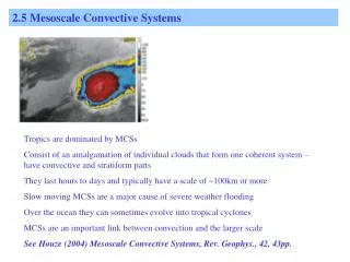
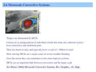
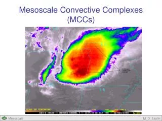
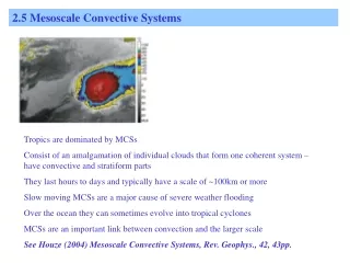
Mesoscale Convective System (MCS) • Commonly occur in the Plains and Midwest • cloud system occurs in connection with a group of thunderstorms --convective • produces a large precipitation area, round/linear - horizontal scale of 100 km or more --meso • Types: tropical cyclones, squall lines, and Mesoscale Convective Complexes (chance for tornado)
MCS Animations • Creation • http://samson.engin.umich.edu/tools/Air_Mass_Thunderstorm/ • Example • http://cimss.ssec.wisc.edu/goes/blog/wp-content/uploads/2011/07/110711_g13_ir_derecho_anim.gif
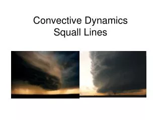
Squall Line • a type of MCS with a larger length to width ratio, continuous or with breaks • form on the leading edge of a cold front, but are separate from the front Image Courtesy of NWS
Squall line continued • increase in wind speed > 18 mph, sustained speed of 25 mph for over 1 minute • tropical squall lines are significantly weaker than the midlatitudesystems, why? • areas with identical temperatures, precipitable water content, and convective potential energy determine the higher intensity • squall lines can merge with supercell systems (severe thunderstorms that have the potential to produce tornadoes) • Chance of an increase in intensity after the merge is 59%
Precipitation Detection • Radar and satellites have added an extensive quantity of data for weather observations • Radio Detection and Ranging - electromagnetic radiation to sense precipitation • Satellite: visible, infrared, water vapor • http://www.crh.noaa.gov/crh/satellite/satellitessd.php?site=ilx • used to improve weather simulations and forecasts • Conventional and Doppler (reflectivity and wind velocity)
rain gauges have been the main method of ground truthing, although stream level recorders can be used to supplement the gages into gaining further insight into spatial patterns of storm events • Multiple mathematical models have been developed to better predict and estimate precipitation spatially, specifically thunderstorm events. • http://www.spc.noaa.gov/exper/ • Examining the patterns of these thunderstorms and the hydrologic cycle can further the accuracy of these estimations. • Newest technology: Dual polarization radar • better detect heavy rainfall in flooding events, detect precipitation type (rain, hail, snow)
Case Study – Balling and Goodrich (2011) • precipitation values and Atlantic Multidecadal Oscillation (sea surface temperatures) were compared and analyzed (1975–2009) to see if correlation exists between the Earth’s warming temperature and higher precipitation levels • concluded that daily precipitation records from the conterminous U.S. reveal that with recent Earth warming, precipitation intensity appears to have increased at a continental scale • “making any direct link between anthropogenic changes in atmospheric composition and increases in precipitation intensity must be done with caution.”
Conclusion • Mesoscale Convective Systems, including squall lines vary in spatial movement and precipitation properties • Potential convection, water vapor, wind shear • Although many models and scientific prediction methods utilizing radar, satellite, and case studies to predict strength of storms along with intense precipitation and wind • The correlation between the Earth’s rising temperatures and higher precipitation values shows the need to update hydrological modeling. • Also, more thunderstorm research, from a hydrologic perspective, is needed for connect meteorological modeling/simulation and effects on hydrologic modeling.
References Balling Jr., R. C., & Goodrich, G. B. (2011). Spatial analysis of variations in precipitation intensity in the USA. Theoretical & Applied Climatology, 104(3/4), 415-421. doi:10.1007/s00704-010-0353-0 Chen, S. S., and W. M. Frank (1993). A numerical study of the genesis of extratropical convective mesovortices. Part I: Evolution and dynamics, Journal of Atmospheric Science, 50, 2401–2426. Chen, Shu-Hua, Zhan Zhao, Jennifer S. Haase, Aidong Chen, Francois Vandenberghe. (2008) A study of the characteristics and assimilation of retrieved modis total precipitable water data in severe weather simulations. Monthly Weather Review, 136, 3608–3628. doi: 10.1175/2008MWR2384.1 Efrat Morin, David C. Goodrich, Robert A. Maddox, XiaogangGao, Hoshin V. Gupta, SorooshSorooshian, (2006). Spatial patterns in thunderstorm rainfall events and their coupling with watershed hydrological response, Advances in Water Resources, 29(6), 843-860, doi: 10.1016/j.advwatres.2005.07.014 French, A. J., & Parker, M. D. (2012). Observations of Mergers between Squall Lines and Isolated Supercell Thunderstorms. Weather & Forecasting, 27(2), 255-278. doi:10.1175/WAF-D-11-00058.1 Groisman, P. a., Knight, R. W., & Karl, T. R. (2012). Changes in Intense Precipitation over the Central United States. Journal Of Hydrometeorology, 13(1), 47-66. doi:10.1175/JHM-D-11-039.1 Hocker, James E., (2008). A 10-year spatial climatology of squall line storms across Oklahoma. International Journal of Climatology, 28 (6), 765-775. doi: 10.1002/joc.1579 Huang, C.-Y., Y.-H. Kuo, S.-H. Chen, and F. Vandenberghe (2005). Improvements in typhoon forecasts with assimilated GPS occultation refractivity. Weather Forecasting, 20, 931–953 Houze ,R. A. Jr. (2004). Mesoscale convective systems. Reviews of Geophysics, 42(4), 1944-9208. doi: 10.1029/2004RG000150 Lundquist, J., Huggett, B., Roop, H., Low, N. (2009). Use of spatially distributed stream stage recorders to augment rain gages by identifying locations of thunderstorm precipitation and distinguishing rain from snow. Water Resources Research, 45(W00D25). doi: 10.1029/2008WR006995 Takemi, Tetsuya (2007). A sensitivity of squall-line intensity to environmental static stability under various shear and moisture conditions. Atmospheric Research, 84(4), 374-389. doi: 10.1016/j.atmosres.2006.10.001