Download
1 / 8

E N D
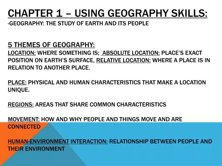
CHAPTER 1 – USING GEOGRAPHY SKILLS:-Geography: the study of earth and its people 5 Themes of Geography:Location: where something is; Absolute Location: place’s exact position on Earth’s surface, Relative Location: where a place is in relation to another place. Place: physical and human characteristics that make a location unique.Regions: areas that share common characteristics Movement: how and why people and things move and are connectedHuman-Environment Interaction: relationship between people and their environment
Human Geographer: Study people and their activities. Physical Geographer: study earth’s land, water, plants and other physical features. Decade – 10 years Century- 100 years Millennium- 1000 years 4 Periods of Human History: 1. Prehistory - before writing; 5,500 years ago 2. Ancient History - until about 1,500 years ago 3. Middle Ages- next 1,000 years- medieval period 4. Modern History- started about 500 years ago to present day
Small-scale maps: show a large land area but little detailLarge-scale maps: show a small land area with a great amount of detail physical maps: show landforms and water features Political maps: show names and political boundaries of countries, along with human-made features such as cities or transportation routes
Historical maps: show events that occurred in a region over time. Contour maps: has contour lines which show one line for each major level of elevationvegetation maps: special purpose maps that show the different types of plants that are found in a region
LATITUDE: IMAGINARY CIRCLES THAT RUN EAST AND WEST AROUND THE GLOBEEQUATOR: CIRCLES EARTH LIKE A BELT; divides northern and southern hemispheres Longitude: also known as meridians, run from north to south poles.Prime meridian: 0 degrees longitude; divides eastern and western hemispheres.
PARTS OF A MAP:Title- what the map is showingkey/legend- explains the symbols, colors, and lines on the map.Scale bar- measuring line helps you figure distance on the map.Compass rose- symbol that tells the cardinal directions- north, south, east, westcities- are symbolized by a (shown on key)capitals- are symbolized by a (shown on key)boundary lines- show the area a certain place takes up.
-Summer Solstice: June 21st; in northern hemisphere; day with the most hours of sunlight; beginning of summer -Winter Solstice: December 22nd; day with fewest hours of sunlight; beginning of winter -Spring and autumn each begin on a day that falls midway between the two solstices – these two days are “equinoxes” – when day and night are equal in length in both hemispheres-Tropics: areas of low latitude near the equator with warmer temperatures
Important world geography facts:-the largest continent is Asia-the smallest continent is Australia -the largest country is Russia-the smallest country is Vatican city, which is one square mile – located in Italy -The longest river is the Nile river located on the continent of Africa -The highest mountain is mt. Everest located in Asia -the largest desert is the Sahara Desert in Africa ** LOOK AT PAGES RA36 – RA37