Download
1 / 22
230 likes | 241 Views
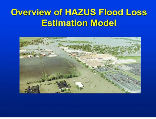
Overview of HAZUS for Flood Loss Estimations. October 7, 2011. What is HAZUS?. Risk assessment tool for analyzing potential losses from hurricane, flood, and earthquake Uses current scientific and engineering concepts in a GIS to estimate hazard related damages

E N D
Overview of HAZUS for Flood Loss Estimations October 7, 2011
What is HAZUS? • Risk assessment tool for analyzing potential losses from hurricane, flood, and earthquake • Uses current scientific and engineering concepts in a GIS to estimate hazard related damages • HAZUS is only an estimation tool for losses due to a disaster and could be significantly different from an actual event
Loss Estimate Process Produce maps, tables, reports Analyze social and economic impacts Consider what is at risk Identify hazard Identify physical
How does HAZUS calculate damages? • HAZUS Flood uses depth/damage curves developed by USACE and other agencies to determine damage to a building based on the flood depth • HAZUS calculates • Losses to buildings and their content and inventory (businesses) value • Debris generation from building damages • Displaced population (used to identify evacuation routes and shelter requirements) • Agriculture Losses due to flooding • Damage to essential facilities (police, fire, medical, schools, and EOC’s) • Damage to transportation facilities (ports, ferry facilities etc.)
HAZUS Inputs for Flood • Level 1 Analysis (For areas with no existing flood data) • Single Discharge or return period (i.e. 100 year discharge is 13,500 cfs or 1% change return period) • Elevation data (DEM, LiDAR etc.) *Needed for all analysis levels • Out of the box HAZUS data • Levee 2 Analysis (Ideal analysis level) • Flood Information tool (generates depth grid from water surface elevation and elevation data. *water surface elevation available through flood insurance study) • Depth grid generated outside of HAZUS using HEC-RAS, FLO-2D etc. • HEC-RAS depth grids are directly input into HAZUS. • User update general building stock, essential facilities, transportation, etc. • Level 3 Analysis (Engineering specific data) • Updated engineering building data • Update depth/damage curves
HAZUS Inputs for Flood • Level 1 Analysis (For areas with no existing flood data) • Single Discharge or return period (i.e. 100 year discharge is 13,500 cfs or 1% change return period) • Elevation data (DEM, LiDAR etc.) *Needed for all analysis levels • Out of the box HAZUS data • Levee 2 Analysis (Ideal analysis level) • Flood Information tool (generates depth grid from water surface elevation and elevation data. *water surface elevation available through flood insurance study) • Depth grid generated outside of HAZUS using HEC-RAS, FLO-2D etc. • HEC-RAS depth grids are directly input into HAZUS. • User update general building stock, essential facilities, transportation, etc. • Level 3 Analysis (Engineering specific data) • Updated engineering building data • Update depth/damage curves
Where do I find data for use in HAZUS? • Local parcel/assessors data can be input into HAZUS. The following data is required for each parcel: • Building replacement value (typically use building improvement value). *Assessed values should not be used. • Building square footage • Building type (residential, commercial, industrial etc. ) • Building count (per parcel) • Elevation data (DEM’s, LiDAR etc.) can be found from various sources such as: • National • USGS Seamless Data Warehouse (http://seamless.usgs.gov/) • FEMA Regional Office • Regional • Puget Sound LiDAR Consortium (http://pugetsoundlidar.ess.washington.edu/) • Oregon LiDAR Consortium (http://www.oregongeology.org/sub/projects/olc/) • Idaho LiDAR Consortium (http://www.idaholidar.org/) • Local Datasets
Where do I find data for use in HAZUS? • FEMA Flood Insurance Studies • Discharges and frequencies • FEMA Flood Insurance Studies • Hydrologic and Hydraulic Flood Models generate water surface elevations (*available where a detailed flood study was preformed) • Water surface and elevation data can be used to generate a flood depth grid • Depth grids can be exported from HEC-RAS and FLO-2D • Other engineering flood studies
RiskMAP Deliverables • Each RiskMAP Study will include flood depth grids for the 10, 50, 100, and 500 year flood frequencies • All flood studies starting from 2009 onward will generate depth grids for any detailed study areas • Level 1 HAZUS Analysis will also be completed in deliverable
How Do I Run HAZUS? • A study region is created first in HAZUS which can be at a state, county, city, census tract, census block level • HAZUS Flood determines losses at a census block level • A building specific analysis can be run in HAZUS, but requires additional building data such as first floor elevation • Flood data is input into the model (single discharge and DEM, depth grid, HEC-RAS output) • Analysis is run for various building types, facilities, debris generation, displaced population etc. • Extract output and display data using ArcGIS
Uses for HAZUS Output • Disaster Response • HAZUS Flood events can be pre-run for use during disaster response • Pre-run flood events allow emergency management to stage resources where the highest damaged is modeled to occur • Single discharge can also be input into HAZUS based on stream gage information during the event
Uses for HAZUS Output • Hazard Mitigation Planning • HAZUS output can be incorporated into a Hazard Mitigation Plan • HAZUS can identify hazard mitigation strategies *Tables were take from the Snohomish County Hazard Mitigation Plan located at http://www1.co.snohomish.wa.us/Departments/Emergency_Management/Information/Plans_Reports/
Uses for HAZUS Output • Community Planning • Future Development • Preparedness • Exercises • Validation Studies
Other Resources for HAZUS • FEMA HAZUS Website - http://www.fema.gov/plan/prevent/hazus/ • HAZUS User Group Information - http://www.usehazus.com/home/ • Washington HUG contact Kelly Stone, kelly.stone@fema.dhs.gov • Idaho HUG contact Ryan McDaniel, ryan.mcdaniel@idwr.idaho.gov or Chris Corwin, ccorwin@co.blaine.id.us • Alaska and Oregon information contact Jennifer Monroe, jennifer.meyer@fema.dhs.gov • Washington State Emergency Management Division • Allen Jacobitz, a.jakobitz@emd.wa.gov or Jamie Mooney, j.mooney@emd.wa.gov • Idaho Bureau of Homeland Security • Mark Stephensen, mstephensen@bhs.idaho.gov • FEMA Regional Office – • HAZUS POC and Elevation Acquisition, Kelly Stone, kelly.stone@fema.dhs.gov • Study information for WA – Kelly Stone, kelly.stone@fema.dhs.gov, ID – Amanda Engstfeld, amanda.engstfeld@fema.dhs.gov, OR and AK, Jennifer Monroe, jennifer.meyer@fema.dhs.gov
HAZUS Training - Online • ESRI Virtual Campus – search for ‘Hazus’ • Examples • Hazus-MH for Decision Makers • Basic Hazus – 12 courses (Fall/Winter 2011) • Introduction to CDMS • User Defined Flood Hazard • Cost ranges from free to $32
HAZUS Training - Classroom • Training available at FEMA’s Emergency Management Institute, http://training.fema.gov/EMI/ • Funding is available for all expenses for State and Local governments • Training available is as follows: • E190 ArcGIS for Emergency Managers • E313 Basic Hazus-MH • E170 Hazus-MH for Hurricanes • E172 Hazus-MH for Floods • E174 Hazus-MH for Earthquakes • E296 Using Hazus-MH for Risk Management • E176 Hazus for Floodplain Managers • E179 Applications of Hazus-MH for Disaster Operations • E317 Comprehensive Data Management for Hazus-MH
Kelly S. Stone, Risk Analyst, FEMA Region X Kelly.stone@dhs.gov 425-487-4636 WA HUG Call – November 3, 2011 9:00-10:00am Call-in # 570-720-0113 PIN 186250, then press # Call information available on http://www.usehazus.com/ Overview of HAZUS for Earthquake Loss Estimations (Online) October 28, 2011 10-11am Registration required Contact and Upcoming Training