Download
1 / 19
220 likes | 282 Views
Autonomous robot using ros & lidar with raspberry matlab. Mapping, Path planning & path following. Introduction. Turtle bot is a well-known product, which uses the technology like SLAM and Navigation best suitable for home service robots.

E N D
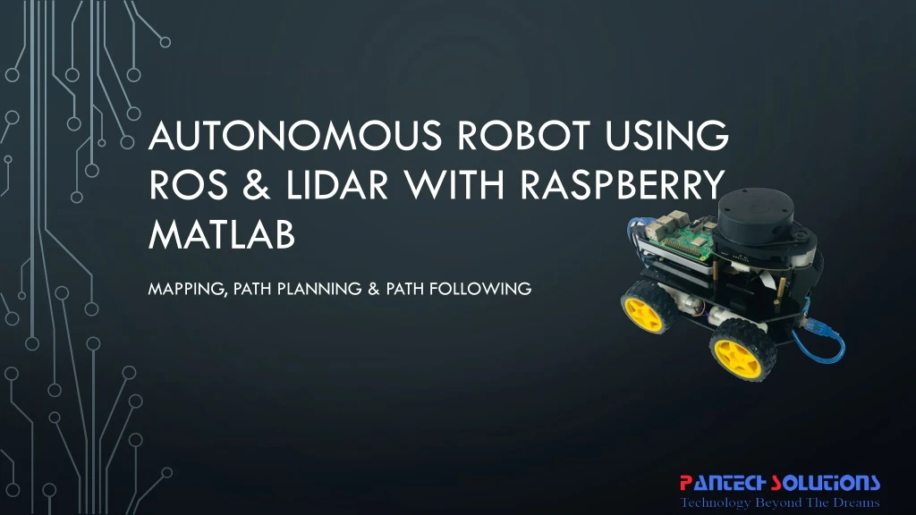
Autonomous robot using ros & lidar with raspberry matlab Mapping, Path planning & path following
Introduction • Turtle bot is a well-known product, which uses the technology like SLAM and Navigation best suitable for home service robots. • It also contains multiple versions based on structure and features. • The bot which is embedded with the gyro, Kinect sensors, Lidar, and laptop. Which has many features like path planning, obstacle avoidance, and path following with localization and mapping. • This Pantech’s ROS Bot is not using Kinect camera, gyro and not customized controllers which makes its low cost
Short about ROS • ROS is the Robot Operating System, which is the group of software libraries used for building the Robotic applications which also has some algorithms with some development tools • There are a lot of versions of ROS. Like ordered alphabetically. • Hydro • Indigo • Jade • Kinetic • Tools of ROS like • Rviz • rosbag • catkin • rosbash • roslaunch
Short about SLAM • SLAM is Simultaneous Localisation and Mapping. By starting with an example, Let us take Google Map which has a complete path of the whole world, Mapping in SLAM resembles that part. Similarly by using GPS (Global Positioning System) every individual is located in that map using the coordinates of Latitude and Longitude. With another example, by using Lidar we can Map the environment as well as by using SLAM Algorithm we can do localization and Mapping at the same time.
Short about Lidar • LIDAR is Light Detection and Ranging uses Light in the form of a pulsed laser to detect the obstacle with its ranges. • And by having continuous obtaining of ranges throughout the environment with precise angle difference between every ranges it is possible to map the whole environment which is known as Laser scans, which includes Ranges, Angles, Cartesian coordinates and Number of the value obtained. • Based on Physical and Scattering process and platform LIDAR has many classifications.
Abstract • This is one of the Low-cost turtle bot, which has simple structure uses ROS (Robotic Operating System) software library of version ROS Kinetic booted with Raspberry Pi and also interfaced with RPLidar in the front top portion of the Bot. • This low-cost turtle bot emerges with features like SLAM (Simultaneous Localization and Mapping), Path planning and Path Following. which has the capability to reach the destination automatically after its destination is fixed in the MAP. • For those Applications, we are using Matlab’s Robotic Operating System Software package to communicate with ROS in the Raspberry Pi using ROS Network Configurations.
Existing system • In the existing robots, High-cost sensors and interfaces are used like Kinect camera and controllers or Laptops merged with RPlidarwhich makes it as expensive Bot than others.
Proposed system • In this proposed system new way of the method to reduce the cost, we used every basic model of hardware like Raspberry Pi as the core of ROS and using Rplidar A1 model which also a 360-degree functional lidar. • For Robot control we are simply using Arduino interfaced with HC-05 Bluetooth to receive commands from the laptop. • And rest of the functionalities like Algorithms like SLAM, Destination Marking, Path Planning and Path following are developed in Matlab using Robotic Operating System in Software Package of the Matlab. • By using ROS Network configurations ROS is communicated from the Matlab.
Project Description • Initially, ROS is connected with the Network (Raspberry Pi) • By using ROS network configuration, the environment should be set in Matlab • After that Publishing the Laser Scan data from the Lidar • Laser scan is received in the Matlab using ROS Network • First Mapping is Done by controlling the turtle bot manually from the Matlab • After complete mapping is done, will go for Destination Marking • In the map, we can plot the destination point in the occupancy grid
Project Description • After fixing the Destination point, path planning Algorithm should be performed, for Path Planning, PRM is used (Probabilistic Road Map) • It will plot the possible way to reach the destination, using the number of nodes and its distance between each node. • After Path planning is done, Path following is done by making the car to follow the desired path using the coordinates. • Every Movement is controlled by the Matlab by sending Bluetooth commands to the turtle bot. At the same time localization is also done to visualize the current position of the Bot. • It Automatically follows the path and reaches the destination.
Hardware used • Raspberry Pi 3 • SD Card 16 GB class 10 • RPLidar A1 • Robo Setup • Power Bank (10000 mAh, 2 A minimum) • Arduino UNO • HC-05 Bluetooth Module • L293D Driver module
Software USED • ROS kinetic OS image for Raspberry Pi • Matlab, which has a Robotic Operating System Software Package • Arduino IDE • SD Card Formatter • Etcher/win32Disk Imager/Rufus
Application • This ROS bot can be used for indoor localization • This Bot can be used for indoor servicing bot • This bot can also be used for indoor cleaning
Result Mapping