Download
1 / 18
180 likes | 302 Views
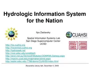
Hydrologic Information System for the Nation. Ilya Zaslavsky Spatial Information Systems Lab San Diego Supercomputer Center UCSD. http://his.cuahsi.org http://hiscentral.cuahsi.org http://hydroseek.net http://river.sdsc.edu/ucsddash http://wron.net.au/DemosII/Modules/ODMKMLGatway.aspx

E N D
Hydrologic Information System for the Nation Ilya Zaslavsky Spatial Information Systems Lab San Diego Supercomputer Center UCSD http://his.cuahsi.org http://hiscentral.cuahsi.org http://hydroseek.net http://river.sdsc.edu/ucsddash http://wron.net.au/DemosII/Modules/ODMKMLGatway.aspx http://maxim.ucsd.edu/mattsmaps/storet.aspx BOM talk, Melbourne, March 19, 2009
SDSC Spatial Information Systems Lab http://spatial.sdsc.edu/lab/ Research and system development • Services-based spatial information integration infrastructure, CI projects • Mediation services for spatial data, query processing, map assembly services • Long-term spatial data preservation • Spatial data standards and technologies for online GIS (SVG, WMS/WFS) • Support of spatial data projects at SDSC and beyond In Geosciences (GEON, CUAHSI, CBEO,…) services In Neurosciences (BIRN, CCDB, WBC) In regional development (NIEHS SBRP, CRN…) Contact: zaslavsk@sdsc.edu
Web Services for Generating SVG Tiny Maps on Mobile Phones Java + Batik Spatial data servers Services for generating object textures for Torque J2ME device .Net + C# Viewers: TinyLine Squiggle Adobe’s ASV
Foveal Coordinate System Hemorrhages Cotton-Wool Fovea Optic nerve Arteries Veins Coordinate System Background
What is the CUAHSI HIS? CUAHSI HIS: NSF support through 2012 (GEO), ~10 mil invested Partners: Academic: 11 NSF hydrologic observatories, CEO:P projects, LTER… Government: USGS, EPA, NCDC, NWS, state and local Commercial: Microsoft, ESRI, Kisters International: Australia, UK Standardization: OGC, WMO (Hydrology Domain WG, CHy); adopted by USGS, NCDC An online distributed system to support the sharing of hydrologic data from multiple repositories and databases via standard water data service protocols; software for data publication, discovery, access and integration.
Map for the US Build a common window on water data using web services Observation Stations Ameriflux Towers (NASA & DOE) NOAA Automated Surface Observing System USGS National Water Information System NOAA Climate Reference Network
NWISWeb site output # agency_cd Agency Code # site_no USGS station number # dv_dt date of daily mean streamflow # dv_va daily mean streamflow value, in cubic-feet per-second # dv_cd daily mean streamflow value qualification code # # Sites in this file include: # USGS 02087500 NEUSE RIVER NEAR CLAYTON, NC # agency_cd site_no dv_dt dv_va dv_cd USGS 02087500 2003-09-01 1190 USGS 02087500 2003-09-02 649 USGS 02087500 2003-09-03 525 USGS 02087500 2003-09-04 486 USGS 02087500 2003-09-05 733 USGS 02087500 2003-09-06 585 USGS 02087500 2003-09-07 485 USGS 02087500 2003-09-08 463 USGS 02087500 2003-09-09 673 USGS 02087500 2003-09-10 517 USGS 02087500 2003-09-11 454 Time series of streamflow at a gaging station
Set of query functions Returns data in WaterML Water Data Services NWIS Daily Values (discharge), NWIS Ground Water, NWIS Unit Values (real time), NWIS Instantaneous Irregular Data, EPA STORET, NCDC ASOS, DAYMET, MODIS, NAM12K, USGS SNOTEL, ODM (multiple sites)
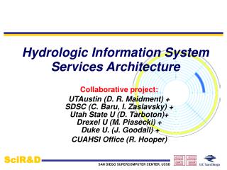
Hydrologic Information System Service Oriented Architecture HIS Lite Servers Test bed HIS Servers Central HIS servers External data providers Global search (Hydroseek) Deployment to test beds Customizable web interface (DASH) Other popular online clients HTML - XML Desktop clients Data publishing HIS CentralRegistry & Harvester Water Data Web Services, WaterML WSDL - SOAP Ontology ETL services Controlled vocabularies Metadatacatalogs ArcGIS WSDL and ODM registration Matlab IDL, R Ontology tagging (Hydrotagger) MapWindow ODM DataLoader Excel Streaming Data Loading Programming (Fortran, C, VB) ODMTools Modeling (OpenMI) Server config tools
Hydroseekhttp://www.hydroseek.net Supports search by location and type of data across multiple observation networks including NWIS, Storet, and academic data
Summary • Cyberinfrastructure for managing and publishing observational data • Supports many types of point observational data • Overcomes syntactic and semantic heterogeneity using a standard data model and controlled vocabularies • Supports a national network of observatory test beds but can grow! • WaterML is a standard language for consistently communicating water observations data from academic and government sources using web services – develops towards OGC standards; already adopted by several federal agencies • National Water Metadata Catalog is the most comprehensive index of the nation’s water observations presently existing (1.75 million stations – the largest in the world) • The system is already deployed in the US and internationally
Business Models • A software product. Hardly… • A data product: • What is the market for it; how expensive is it to maintain, what is the model (subscription?) • A specialized search engine, with ad revenue? • A service • Setting up HIS servers; preparing data; developing integration solutions, consulting, etc. • A cyberinfrastructure product??
What is a cyberinfrastructure product? • CI: mixed ownership and licensing models, hodgepodge of technologies, autonomously managed, assembled on demand for more or less common scenarios • There should be governance and mediation to make CI work. Potential CI vantage points: • Controlling standards development and adoption; object identifiers, ontologies and controlled vocabularies • Being the “first compliant software” • Automatic endorsement by federal and other agencies, international market? • Controlling access to CI tools • The value of CI grows as it grows, and more users and data contributors join in