Download
1 / 27
270 likes | 374 Views
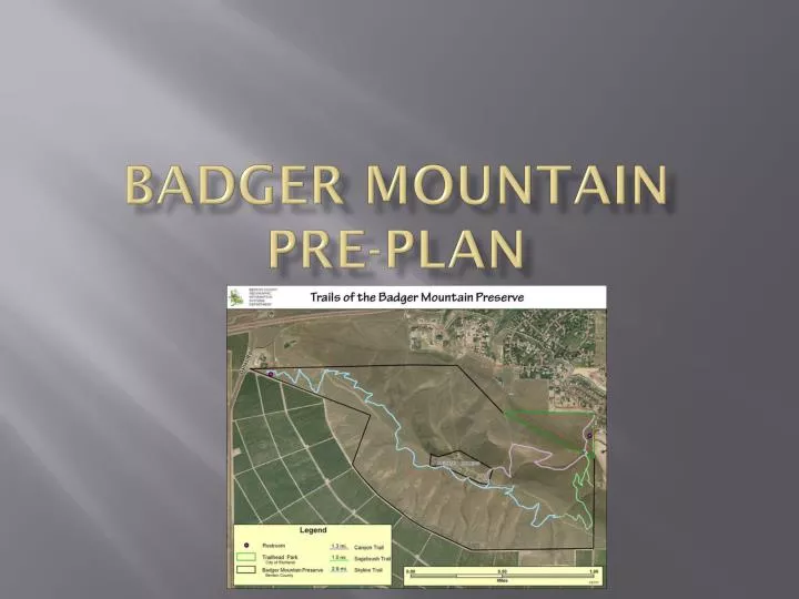
BADGER MOUNTAIN PRE-PLAN. WHAT’S BEEN GOING ON. For the past six months, RFD has worked with Benton County Parks/Rec, Friends of Badger Mountain, and BCFD#1 Looking for ways to improve our EMS and fire response to the mountain. Popularity is Soaring!.

E N D
WHAT’S BEEN GOING ON • For the past six months, RFD has worked with Benton County Parks/Rec, Friends of Badger Mountain, and BCFD#1 • Looking for ways to improve our EMS and fire response to the mountain
Popularity is Soaring! • Estimated that over 170,000 people climbed mountain in 2012 • Increase of 50,000 from 2011
Impact to Fire/EMS • Increase in calls for service • 6 calls in 2012 • 1 working code in 2010, in addition to other calls • Potential for increase in call volume
Problems Identified(Access) • Service Road is accessible by ambulance • Many of the trails, however, are not • 4x4 vehicle needed
Problems Identified(Manpower) • Takes several hands to carry someone off trail • Due to accessibility, fatigue will happen quickly • Do current run cards account for this? • NO!
Types of Calls • Chest pain • Shortness of breath • Slips, Trips, Falls • Heat/Cold Injuries • Bicycle Wrecks • Dog Bites • Snake Bites • Anaphylactic Reaction • Diabetic • Other Medical/Trauma • Fire
Why the Big-to-Do Now?? • Because we are behind the 8-ball • Shift in fire/ems from reactive to proactive • Pre-planning is a must • Will help mitigate future calls for service
Problems Identified(Caller doesn’t know location) • Have had several instances of this • Event on 8/16/12 • Chest pain call • 20 minutes to locate • Contrary to popular belief, dispatch cannot GPS location using cell phone • Washington State Emergency Management • FCC 911 Guidelines
Problems Identified(Weather) • Safety factor for hikers and responders • Will make access more difficult • May exclude landing of MedStar
Problems Identified(Increased Popularity) • Number of people using mountain goes up every year • Also a good thing!! • Badger South Development • Larger range of age-groups making hike
What is the Solution?(Access) • Become familiar with the trails and access points • Updated maps in MDT’s • MedStar • Predetermined LZ’s
What is the Solution?(Manpower) • Updated run cards • Increase in number of personnel responding • Pre-staging of equipment • Rescue Litter and Rescue Mule Litter Wheel at top and bottom of mountain
What is the Solution?(Caller unaware of location) • Mile markers and Signposts • “People often don’t pay attention to the trailmarkers” ~Larry Nunez, Phoenix Fire • Lifesaving value is real • Scottsdale, AZ McDowell Sonoran Preserve • Could become trend/serve as example: • As Benton County works to create countywide trail and path network • Parks and Rec Master Plan
UPDATED RUN CARDS • Badger Mountain has been listed as a special address at SECOMM • There are three addresses listed for mountain • 5305 East 210 PR NE, Richland, WA • This is off of Dallas Road • 525 QueensgateDr, Richland, WA • Also known as Trailhead Park • @West end of Bermuda Rd • New run cards will add more staff and appropriate off-road capable apparatus • Also puts MedStar on standby • At a minimum you will get 9 personnel responding
PRE-STAGING OF EQUIPMENT • Rescue Litter • Benton County purchased two (2) rescue litters • BCFD1 and BCFD2 donated Stokes Baskets • The combination will improve patient transport • Equipment will be staged in two (2) locations • At the base of the hill at 525 Queensgate Drive • Will be located in the bathroom in Trailhead Park • At the top of the hill in the repeater tower building • The building is the one on the far east
HOW TO GET IN THESE BUILDINGS • Supra-S boxes will be staged on both buildings • One will also be staged at gate on service road off of Dallas Rd • Key/Combination will be located inside each box to allow entry • Code for boxes is “R-F-D”
LOCATING THE PATIENT • Each trail will have individualized trail markers spaced every .25 miles • Markers will be color-coded and numbered • When call is made to 911, caller will be able to identify the trail marker, providing the color and number to dispatch • So… how does this help us?
LOCATING THE PATIENT • Each trailmarker will be GPS-located • A map, with trailmarkers, will be uploaded in our MDT’s • Dispatch will be able to provide us with the trailmarker location, and we will be able to tell the exact location of the injured person • Will allow us to determine best access point • Will save valuable minutes and allow care to start sooner
LANDING ZONE/REFERENCE POINT MAP • That last picture didn’t come through very well. • We apologize. • There will be a better picture on the MDT
DISPATCH RESPONSIBILITIES • As stated in previous slide, there will be trailmarkers that are color-coded with corresponding numbers on them • You will be provided with a map containing these markers, and the corresponding locations • Please prompt the callers with the following information after they identify that they are on Badger Mountain: • Tell them to look on the trail for a marker • The marker may be in front of them or behind them • The markers are spaced every .25 miles • Ask them to identify the color of the marker and the number that is listed • Relay that information to responding units so we can pinpoint their location and identify best access
RESPONDER RESPONSIBILITIES • Determine location based upon milepost and color of trailhead. • Dispatch the proper apparatus to the pre-determined locations for the quickest patient access • Based upon patient condition put MedStar on Stand-by or Launch. • 1st arriving apparatus, gather litter from summit or base and go to patient. • Additional resources stage at pre-determined location and communicate needs to the patient crew.
RESPONDER RESPONSIBILITIES • Identify best route for evacuating patient uphill or downhill. • Get medic units to the patient evacuation area. • Use tactical radio channels if necessary (think of topography and tac channel limitations –vs- geographic channels) • Establish an IC to coordinate rescue/care • If landing MedStar identify a lead person to communicate landing and ensure a clear zone at the LZ.
WHAT ELSE… • The plan also includes a public information piece to educate the hiking public. • We will have new signs at the trailheads • Fire danger signs will be posted • Possibility of having PSA’s and announcement in utility bills • In the future we are looking at an Early Alert System for fires on the mountain • Also examining the possibility of establishing “safety zones” on the mountain in the event of a fire
MOST IMPORTANT… • Get your hands on the equipment • Practice with it • Put someone in the basket • If you can… hike the mountain to become familiar with the trails • Questions? E-mail Duncan or Hardgrove