Download
1 / 21
210 likes | 409 Views
Development and Implementation of FGDC Standards . Presented by Julie Binder Maitra Federal Geographic Data Committee (FGDC) To Second Earth Science Data Systems Working Group (ESDSWG) Meeting October 19, 2004. Development and Implementation of FGDC Standards. Introduction to the FGDC

E N D
Development and Implementation of FGDC Standards Presented by Julie Binder Maitra Federal Geographic Data Committee (FGDC) To Second Earth Science Data Systems Working Group (ESDSWG) Meeting October 19, 2004
Development and Implementation of FGDC Standards • Introduction to the FGDC • Federal guidance on the National Spatial Data Infrastructure (NSDI) • Components of the NSDI • FGDC Organization • FGDC Standards Development Process • FGDC Standards Accomplishments • Non-Federal standards • Framework Data Standards
Federal guidance on NSDI • Executive Order 12906 (April 1994) establishes the National Spatial Data Infrastructure (NSDI) as “the technology, policies, standards, and human resources necessary to acquire, process, store, distribute, and improve utilization of geospatial data.” • OMB Circular A-16 (Revised August 2002) • incorporates EO 12906 and affirms the NSDI. • establishes the FGDC as the interagency coordinating body for NSDI-related activities
Clearinghouse (catalog) Metadata GEOdata Framework Standards Partnerships Components of the NSDI
FGDC Organization Federal agency members • Transportation • EPA • FEMA • Library of Congress • NARA • NASA • NSF • Department of State • TVA • USDA • Commerce • Defense • NIMA • USACE • Energy • GSA • HUD • HHS • Interior • Justice
FGDC Standards Process • The FGDC Standards Process is: • Structured • Iterative • Well-documented • The FGDC develops standards for geospatial data only when there are no non-Federally authored standards that fulfill agency missions and program needs • The FGDC standards development process is modeled after ISO and ANSI standards processes
STAGE STEP CUSTODIAN PROPOSAL 1- Develop Proposal FGDC Standards Working Group (SWG) 2 - Review Proposal SWG PROJECT 3 - Set Up Project FGDC Subcommittee or Working Group (SC/WG) DRAFT 4 - Produce Working Draft Standards Development Group 5 - Review Working Draft SC/WG REVIEW 6 - Review and Evaluate Committee Draft SWG 7 - Approve Standard for Public Review FGDC Coordination Group (CG) 8 - Coordinate Public Review FGDC Secretariat 9 - Respond to Public Comments Standards Development Group 10 - Evaluate Responsiveness to Public Comments SWG 11 - Approve Standard for Endorsement CG FINAL 12 – Endorsement FGDC Steering Committee FGDC Standards Process
FGDC Standards Process The FGDC Standards Process is iterative
FGDC Standards Process • The FGDC Standards Process is documented in: • FGDC Standards Reference Model, http://www.fgdc.gov/standards/refmod97.pdf • 13 supporting FGDC Directives, http://www.fgdc.gov/standards/directives/directives.html
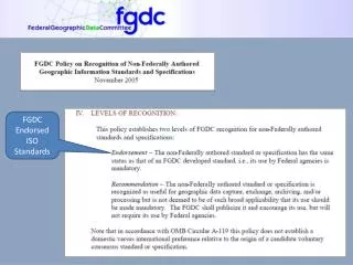
FGDC Standards Accomplishments • 20 FGDC Endorsed Standards • First standard endorsed in 1995: Content Standard for Digital Geospatial Metadata (version 2.0), FGDC-STD-001-1998 • Latest standard endorsed in August 2002: Content Standard for Digital Geospatial Metadata: Extensions for Remote Sensing Metadata, FGDC-STD-012-2002 • Other endorsed standards include: • Spatial Data Transfer Standard (SDTS) & profiles • Geospatial Positioning Accuracy Standards • Various thematic data standards • 19 other Standards in various stages of the FGDC Standards Process
Geographic Information Standards Activities in the United States Is U.S. member body of ISO Is a Technical Committee of ISO Technical Committee (TC) 211 ISO/TC 211 – Joint Advisory Group (JAG) Accredits INCITS L1 as U.S. TAG to Chairs MOU American National Standards Institute (ANSI) ICSP NIST Is accredited by Reports to InterNational Committee on Information Technology Standards (INCITS) OMB Consortia and Academia Is a Subcommittee of Sets Policy For Participate in standards development Is an advisory member of OMG W3C OASIS etc. Is a voting member of Open Geospatial Consortium State FGDC INCITS Technical CommitteeL1 Municipalities Is strategic member of Other Standards Development Organizations ANSI Accredited Standards Development Organization Federal Standards
FGDC participation in non-Federal standards organizations • ISO Technical Committee 211, Geographic information/Geomatics, is focused on abstract specifications, design framework, and international political consensus • Open Geospatial Consortium specializes in extending the abstract model into implementation specifications • FGDC and INCITS Technical Committee L1, GIS, support the development of thematic data content standards
Framework Data Themes Rail Air Roads Elevation Transportation Transit Base Standard Waterways Cadastral Geodetic Control Governmental Units Orthoimagery Hydrography
Development of Framework Data Standards • Develop standards through procedures established by the American National Standards Institute (ANSI) and InterNational Committee for Information Technology Standards (INCITS). • Bring together subject matter experts from all levels of government (Federal, State, and local), academia, and the private sector to develop data standards for Framework themes • Use ISO 19100 series of geographic information standards developed by ISO Technical Committee 211, Geographic information/Geomatics, ANSI standards, and FGDC standards to develop Framework data standards • Apply ISO General Feature Model to define feature types • Provide UML modeling support • Provide documentation of feature types in data dictionary • Map UML data models to XML/Geography Markup Language schema documents
Application of ISO General Feature Model Revised UML data model for Governmental Unit Boundaries
Data Dictionary Documentation Excerpt from data dictionary for GUB_GovernmentalUnit class
Map UML Models to XML/GML Schemas • UML data models in .xmi format were transformed to XML/Geography Markup Language (GML) schemas through UGAS software tool • The XML/GML schema documents can be used to create, validate, and process geographic information with XML parsing and validation software. • Activity supported through Information Interoperability component of the Open Geospatial Consortium’s Open Web Services 2.0 Testbed
Status of Framework Data Standards • Standards project is registered as INCITS Project 1574-D, Geographic Information – Framework Data Content Standard • Objective is an American National Standard (ANS) • Standards initially developed through Geospatial One-Stop e-government initiative, but FGDC has assumed leadership for further development • Draft standards out for public review until October 30, 2004 • The FGDC funded projects across the U.S. to serve and use Framework data over the web using the Open Geospatial Consortium’s Web Feature Service (WFS) specification.
Resources • FGDC, www.fgdc.gov • Framework Standard Registered Review site, http://www.fgdc.gov/RReview • INCITS Technical Committee L1, www.incits-l1.org • ISO Technical Committee 211, www.isotc211.org • Open Geospatial Consortium (formerly OpenGIS Consortium), www.opengeospatial.org • Mapping an ISO 19100 UML Application Schema to a GML Application Schema, http://www.interactive-instruments.de/ugas • Object Management Group, www.omg.org (UML specification and .xmi format) • W3C, www.w3c.org (XML specification)
Julie Binder Maitra FGDC Standards Coordinator Email: jmaitra@fgdc.gov Phone: 703 648 4627 URL: http://www.fgdc.gov/standards/standards.html