Download
1 / 31
320 likes | 455 Views
* C PC Morph ing Technique. The Evaluation of a Passive Microwave-Based Satellite Rainfall Estimation Algorithm with an IR-Based Algorithm at Short time Scales. Robert Joyce RS Information Systems John Janowiak Climate Prediction Center/NCEP/NWS

E N D
*CPC Morphing Technique The Evaluation of a Passive Microwave-Based Satellite Rainfall Estimation Algorithm with an IR-Based Algorithm at Short time Scales Robert Joyce RS Information Systems John Janowiak Climate Prediction Center/NCEP/NWS Phillip Arkin ESSIC – University of Maryland Pingping Xie Climate Prediction Center/NCEP/NWS 2nd International Precipitation Working Group October 25-28, 2004
Outline • 1. CMORPH concept • 2. CMORPH methodology • 3. Validation • 4. Improvement potential and future work • 5. Conclusions
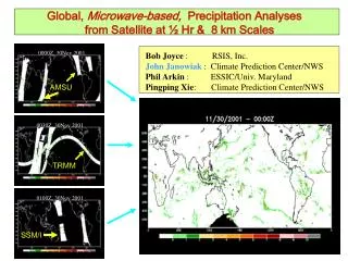
At present, precipitation estimates are used from various passive microwave sensor types on 8 platforms: • AMSU-B (NOAA 15, 16, 17) • SSM/I (DMSP 13, 14, 15) • TMI (TRMM – NASA/Japan) • AMSR-E (Aqua) NOAA/NESDIS (Ferraro et al) “CMORPH” is not a precipitation estimation technique but rather a method that creates spatially & temporally complete information using existingprecipitationproducts that are derived from passive microwave observations.
TMI rainfall estimates from NASA’s 2A12 algorithm (Kummerow et al., 1996) Goddard Profiling (GPROF) version 5, soon version 6 AMSR-E precipitation estimates from GPROF-6 rainfall algorithm run at NOAA/NESDIS/ORA. SSMI precipitation estimates from NOAA/NESDIS/ORA GPROF-6 SSMI rainfall algorithm. AMSU-B rainfall estimates from new NESDIS/ORA AMSU-B rainfall algorithm (Weng et al., 2003) Half hourly, 0.0727 lat/lon (8 km at equator) resolution arrays (separate for each sensor type) are assigned the nearest rainfall estimate within swath regions Averaging of retrieval estimates within same grid points (AMSR-E and TMI only) Anomalous microwave estimated rainfall screened with NESDIS Satellite Services Division (SSD) daily Interactive Multi-sensor Snow and Ice Mapping System (IMS) product
3-hr mosaic: good coverage but time of obs. varies by 3 hrs • PMW rainfall gridded to 8km resolution MANY thanks to NESDIS/OSDPD & R. Ferraro (NESDIS/ORA)
3-hr mosaic: good coverage but time of obs. varies by 3 hrs • PMW rainfall gridded to 8km resolution
IR Data • All 5 geostationary meteorological satellites • Obtained via McIDAS • Merged into ½ hr global (60N-60S), ~ 4 km maps • Corrections for limb darkening & parallax applied Refs: Janowiak et al., Bull. Amer. Meteor. Soc., Feb 2001) Joyce et al., J. Appl. Meteor., Apr 2001 Most recent 8 days (each ½ hr period) available at: ftpprd.noaa.gov: pub/precip/global_full_res_IR
Advection Vector Components Zonal Meridional 20Z March 7, 2004
CMORPH RADAR Hourly Rainfall during 06UTC to 23UTC on Oct 5, 2003
Satellite - CPC gauge analysis Merged PMW – only & Radar Difference from gauge analysis
Satellite - CPC gauge analysis CMORPH & Radar Difference from gauge analysis
Radar CMORPH RADAR Merged PMW Comparison with U.S. Gauge Analyses
DJF 2003-2004 statistics using Australian Bureau of Meteorology 0.25 degree lat/lon daily rain gauge analyses for validation • Red line = CMORPH • Blue line = Merged PMW • Black = gauge analyses
Limitations • Present estimation algorithms cannot retrieve precip. over snow or • ice covered surfaces • - New algorithms being developed (Liu, Ferraro) • Data Latency: ~ 18 hours past real-time • Will not presently detect precip. that develops, matures & decays • between microwave scans • Limits on how far back data can be processed … early 1990’s?
Hourly, 0.25 degree lat/lon CMORPH timestamp = 1 (30 minutes from nearest PMW scan) correlation with Stage II radar rainfall (top panel) • Hourly, 0.25 degree lat/lon IR-based PMW/IR combined frequency matching rainfall estimation (IRFREQ) correlation with Stage II radar rainfall (2nd from top) • CMORPH – radar rainfall correlation minus IRFREQ • Correlation pair counts
Hourly, 0.25 degree lat/lon CMORPH timestamp = 2 (60 minutes from nearest PMW scan) correlation with Stage II radar rainfall (top panel) • Hourly, 0.25 degree lat/lon IRFREQ correlation with Stage II radar rainfall (2nd from top) • CMORPH – radar rainfall correlation minus IRFREQ • Correlation pair counts
Hourly, 0.25 degree lat/lon CMORPH timestamp = 3 (90 minutes from nearest PMW scan) correlation with Stage II radar rainfall (top panel) • Hourly, 0.25 degree lat/lon IRFREQ correlation with Stage II radar rainfall (2nd from top) • CMORPH – radar rainfall correlation minus IRFREQ • Correlation pair counts
Hourly, 0.25 degree lat/lon CMORPH timestamp = 4 (120 minutes from nearest PMW scan) correlation with Stage II radar rainfall (top panel) • Hourly, 0.25 degree lat/lon IRFREQ correlation with Stage II radar rainfall (2nd from top) • CMORPH – radar rainfall correlation minus IRFREQ • Correlation pair counts
The cumulative percentage of half hourly periods sampled for an eight day period, in 30 minute increments to nearest past/future scan, instantaneous (timestamp = 0, top) • cumulative % sampled within 30 minutes of half hourly frame (timestamp <= 1, middle) • cumulative % sampled within 60 minutes of half hourly frame (timestamp <= 2)
Half hourly, 0.25 degree lat/lon CMORPH correlation against withheld MWCOMB rainfall 23 June – 6 August 2004. Temporal distance of CMORPH to nearest PMW scan = 30 minutes (timestamp = 1, top) • Half hourly, 0.25 degree lat/lon IRFREQ correlation against withheld MWCOMB rainfall (timestamp = 1, 2nd from top) • CMORPH correlation minus IRFREQ (3rd from top) • # of correlation pairs (bottom)
Half hourly, 0.25 degree lat/lon CMORPH correlation against withheld MWCOMB rainfall, temporal distance of CMORPH to nearest PMW scan = 60 minutes (timestamp = 2, top) • Half hourly, 0.25 degree lat/lon IRFREQ correlation against withheld MWCOMB rainfall (timestamp = 2, 2nd from top) • CMORPH correlation minus IRFREQ (3rd from top) • # of correlation pairs (bottom)
Half hourly, 0.25 degree lat/lon CMORPH correlation against withheld MWCOMB rainfall, temporal distance of CMORPH to nearest PMW scan = 90 minutes (timestamp = 3, top) • Half hourly, 0.25 degree lat/lon IRFREQ correlation against withheld MWCOMB rainfall (timestamp = 3, 2nd from top) • CMORPH correlation minus IRFREQ (3rd from top) • # of correlation pairs (bottom)
Half hourly, 0.25 degree lat/lon CMORPH correlation against withheld MWCOMB rainfall, temporal distance of CMORPH to nearest PMW scan = 120 minutes (timestamp = 4, top) • Half hourly, 0.25 degree lat/lon IRFREQ correlation against withheld MWCOMB rainfall (timestamp = 4, 2nd from top) • CMORPH correlation minus IRFREQ (3rd from top) • # of correlation pairs (bottom)
Daily times series of correlation comparing IRFREQ, CMORPH, and CMORPH-IR 0.25 degree lat/lon rainfall estimates with same high-quality rain gauge and radar analyses over the U.S. for the 7 May – 27 July 2004 period. IRFREQ = blue lines CMORPH = green lines CMORPH-IR = red lines
FUTURE WORK • Improve accuracy of CMORPH PMW rainfall vectors • Continue to investigate model winds – GMORPH • Continue investigation into the development of CMORPH – IR
Satellite Estimated Rainfall Validation over United States: http://www.cpc.ncep.noaa.gov/products/janowiak/us_web.shtml Australia: http://www.bom.gov.au/bmrc/wefor/staff/eee/SatRainVal/dailyval.html CMORPH Web:http://www.cpc.ncep.noaa.gov/products/janowiak/cmorph.html (includes data access info.) E-mail:john.janowiak@noaa.gov or robert.joyce@noaa.gov Paper: Joyce, R. J., J. E. Janowiak, P. A. Arkin and P. Xie, 2004: CMORPH: A method that produces global precipitation estimates from passive microwave and infrared data at high spatial and temporal resolution. J. Hydromet. Vol. 5, No. 3, pages 487-503. Further Information The End – Thank You