Download
1 / 14
140 likes | 146 Views
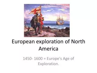
First European to cross North America. In 1793 Alexander Mackenzie, a Scott, made the first East to West crossing of the Americas north of Mexico The Mackenzie River, the longest river in Canada, is named after him

E N D
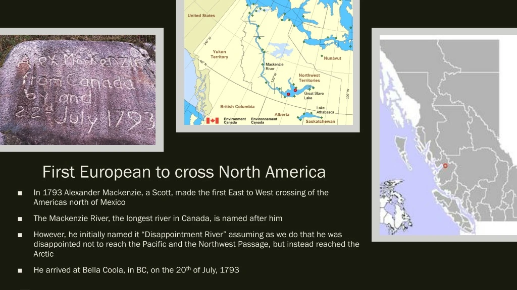
First European to cross North America • In 1793 Alexander Mackenzie, a Scott, made the first East to West crossing of the Americas north of Mexico • The Mackenzie River, the longest river in Canada, is named after him • However, he initially named it “Disappointment River” assuming as we do that he was disappointed not to reach the Pacific and the Northwest Passage, but instead reached the Arctic • He arrived at Bella Coola, in BC, on the 20th of July, 1793
Fun (??) fact: • In 1812 Mackenzie, then aged 48, returned to Scotland, where he married 14-year-old Geddes Mackenzie, heiress of Avoch. He died 8 years later.
Moving West… • Thirty-five years before the fall of New France (in what year?), other events were happening in the Old World that had a strong impact on the west coast fur trade • In 1725, in Leningrad, Russia, Czar Peter the Great of Russia hired the Danish navigator Vitus Bering to find a way to the New World via Siberia • Bering discovered the strait which separates Asia from America, and it was of course named after him • However, he also made another discovery that really excited the Russians…
Beavers and otters and fish oh my! • The beaver had played a major role in the development of eastern, central and western Canada, however, the development of Pacific Canada began with the sea otter • The sea otter had been hunter for thousands of years by the Aleuts of the Aleutian Islands in the north, and to the south by the Tlingit, the Haida, the Tsimshian and the Nootka • The Russians were quick to recognize the economic value of this discovery and wanted to corner the market pretty quickly • They formed the Russian-American Company, which led to Russian land claims in the area • From the 1740s onwards, more and more fur traders from Siberia came to the northwest coast • The Russians maintained control of Alaska until 1867
The Spanish get involved • By 1770 the Spanish were getting worried that the Russians would take control over the whole west coast • Thus they very quickly built a string of settlements from San Diego to San Francisco in California, and then moved up the coast to BC • They claimed sovereignty here in 1774!
The Spanish get involved • Viva España??
Some places in BC with Spanish names… • Spanish Banks • Quadra Island • Juan de Fuca Strait • Galiano Island • Flores Island • Port Alberni • Tofino • Zayas Island • Ballenas Island • Cordero channel
Short lived claims • This did not last long, for in 1778, the British arrived • Captain James Cook of the British Navy was exploring the Pacific coast in search of (what else) the Northwest Passage • He also saw the sea otters and got excited about the potential wealth • His first response was to try to establish British rights over the region
Vancouver… • Accompanying James Cook on this voyage was Captain George Vancouver • Vancouver immediately began to chart large areas of the Pacific Coast, giving all the landmarks English names – including the 2 obvious suspects • In 1793 he even began to explore the inlet which Alexander Mackenzie approached from the other direction 6 weeks later • Now the British had a double claim to the ownership of the North Pacific – they had a maritime claim because of Vancouver, and an overland claim because of Mackenzie • The Spanish would have liked to drive the British from the Pacific, however, they could not stand up to Britain’s superior naval power, and after a few skirmishes, they admitted defeat • By the mid-1790s, the Spanish flag was lowered and replaced by the Union Jack
George Vancouver’s buddies Vancouver named many features for his officers, friends, associates, and his ship Discovery, including: • Mount Baker – after Discovery's 3rd Lieutenant Joseph Baker, the first on the expedition to spot it • Mount St. Helens – after his friend, Alleyne Fitzherbert, 1st Baron St Helens • Puget Sound – after Discovery's 2nd lieutenant Peter Puget, who explored its southern reaches. • Mount Rainier – after his friend, Rear Admiral Peter Rainier. • Port Gardner and Port Susan, Washington – after his former commander Vice Admiral Sir Alan Gardner and his wife Susannah, Lady Gardner. • Whidbey Island – after naval engineer Joseph Whidbey. • Discovery Passage, Discovery Island, Discovery Bay and Port Discovery.
Into the future… • The border between the British colonies and the United States had been drawn in 1818, and it followed the 49th parallel until the Rockies • West of the mountains, both sides had agreed to share • However, in the 1820s masses of immigrants from across the Atlantic started streaming in to the United States and huge numbers of new settlers began to move across the mountains • The Untied States began to make very strong claims on the whole area, right up to Alaska’s borders. • Naturally, Britain was not wiling to give up land rights without a struggle at this point • Suddenly their attention was distracted by the small matter of a full-scale war with Mexico (after the US annexed Texas), and the United States dropped the issue • In 1848 Britain and the United States finally negotiated a treaty to extend the 49th parallel all the way to the Pacific, as well as Vancouver Island • At this point Hudson’s Bay fur traders had establish fur-trading forts at Fort Langley and Fort Vancouver
Phew…? • The international boundary seemed set from coast to coast and an American takeover of Canada seemed averted forever • However, after the California goldrush in 1849 exhausted their goldfields, gold was discovered in the Fraser River in 1858, on the Canadian side of the Oregon border • This brought American miners rushing up the coast in huge numbers, and British authority over the area was threatened again
Fort Langley – capital of BC? • To secure their hold on the area, the British announced that the mainland would be called British Columbia, and its capital would be Fort Langley • The population expanded up to over 10 000 as miners moved up the Fraser Valley into the Cariboo interior to search of gold • When gold was discovered in the interior, near Barkerville, it became the gold mining centre of the west coast • The gold rush continued through the 1860s • By 1866, the British combined the two colonies of Vancouver Island and mainland into the colony of British Columbia • Although the gold boom soon died, a permanent population had now been established • Cities like Victoria and Vancouver were no longer isolated fur-trading centres, and the British presence on the west coast was here to stay