Download
1 / 16
160 likes | 291 Views
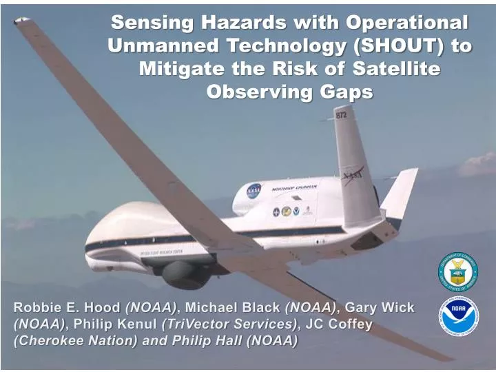
Sensing Hazards with Operational Unmanned Technology (SHOUT) to Mitigate the Risk of Satellite Observing Gaps. The NOAA Unmanned Aircraft Systems (UAS) Program: Status and Activities . Gary Wick Robbie Hood, Program Director.

E N D
Sensing Hazards with Operational Unmanned Technology (SHOUT) to Mitigate the Risk of Satellite Observing Gaps The NOAA Unmanned Aircraft Systems (UAS) Program:Status and Activities Gary Wick Robbie Hood, Program Director Robbie E. Hood (NOAA), Michael Black (NOAA), Gary Wick (NOAA), Philip Kenul(TriVector Services), JC Coffey (Cherokee Nation) and Philip Hall (NOAA)
Progression of Global Hawk Successes • NASA / NOAA Global Hawk Pacific (2010) • First Global Hawk science mission • Long duration and range; latitudes from 12 to 85 degN • NASA Genesis and Rapid Intensification Processes (2010) • Safe overflights of tropical cyclones for extended durations • Real-time data delivery • Ability to change flight plans during flight • Coordination of the Global Hawk with other aircraft • NOAA Winter Storm Pacific and Atmospheric Rivers (2011) • First operational dropsonde deployment, 177 sondes total • First dropsonde in the Arctic since 1950s • Real time changes of drop locations • NASA Hurricane and Severe Storm Sentinel (2011 – 2014) • Remote deployment of the Global Hawk • Use of 2 Global Hawks • Introduction of new instruments • Dropsonde data processed and delivered in real-time to NWS and NHC • G-IV dropsonde intercomparison • Increased flight planning/modification flexibility
Impact of HS3 Dropsondes for Navy COAMPS-TC Hurricane Nadine Predictions Intensity: Max. Wind Error (kts) Track Error (nm) No drops No drops HS3 drops HS3 drops Bias (dash) Intensity: Min. SLP Error (hPa) No drops • Dropsonde impact experiments performed for 19-28 Sep. (3 flights) • Red: with HS3 drops • Blue: No drops with synthetics • COAMPS-TC Intensity and Track skill are improved greatly through assimilation of HS3 Drops. HS3 drops Bias (dash) Slide courtesy of James Doyle / NRL
HS3 2014 • 5th week in place on NASA schedule • August 26 to September 29, NASA Wallops • NOAA adding: • Up to 5 flights • 240 dropsondes • Mission science guidance • Targeting input • Real-time data transmission/assimilation planned
NOAA SHOUT Dedicated Missions • September – November, NASA Armstrong • Tropical cyclones and high impact weather targets • Single deployment location adds targeting flexibility • Early period: Tropical cyclones • Forecast improvements for track and intensity • Option for both Atlantic and Pacific Basins • Atlantic tradeoff of deployment costs vs station time • Later period: High-impact storms affecting the continental US and Alaska • Coastal flooding • Atmospheric rivers • Forecast improvement for threats such as extreme precipitation and damaging winds • Targeted lead times of 3-7 days
Potential Payloads from HS3 • Environment Observations • Profiles of temperature, humidity, wind, and pressure (AVAPS) • Cloud top height (CPL) • Cloud top temperature and profiles of temperature and humidity (S-HIS) • Over-storm Observations • Doppler velocity, horizontal winds, and ocean surface winds (HIWRAP) • Profiles of temperature and humidity and total precipitable water (HAMSR) • Ocean surface winds and rain(HIRAD)
SHOUT Targeting Strategies • Flight plans to optimize forecast impact • Tropical cyclones • SUNY group proposed to explore • Interactions with AOML/ESRL • High-impact weather events • Toth (ESRL) proposed to explore methodologies • Identification of threat cases • Fully automated Ensemble Transform sensitivity algorithm to identify sensitive areas • Produce “optimized” flight track to sample sensitive region for selected threat
WISPAR Winter Storms Flight Sensitivity Forecast Valid 00Z Mar 4 (colors) Valid 12Z Mar 4 (contours)
Next Steps • SHOUT Working Group to meet May 7-8 • Representation from OAR, NWS, NESDIS, and OMAO • Need to resolve: • Timing and duration of field campaigns • Use of one or two aircraft for deployment • Optimal use and choice of instrumentation • Metrics to quantify impact of SHOUT missions • Priority of real-time transmission from various instruments
Desired Input • Guidance on obtaining forecast impact • Target regions • Timing of observations • Recommendations on instrumentation • Flight planning considerations
SHOUT Contact Information • Robbie Hood / robbie.hood@noaa.gov • Michael Black / michael.black@noaa.gov • Gary Wick / gary.a.wick@noaa.gov • Philip Kenul / philip.m.kenul@noaa.gov • JC Coffey / john.j.coffey@noaa.gov • Philip Hall / philip.g.hall@noaa.gov
Assimilation of GH dropsondes in HWRF HWRF Domains • Observation errors: • Temperature, moisture, and wind errors are assigned as a function of vertical pressure • Potential issues with GH dropsondes assimilation: • When available, data has good temporal and spatial coverage in the inner domain; however data is not available for every cycle • Dropsondes drift problem; the GPS measured geo-locations at each pressure level are not included in PREPBUFR Slide courtesy of Vijay Tallapragada / NCEP
Hurricane Nadine 14L 2012 • Verification for HWRF forecast from cycles with Global Hawk Dropsondes for H. Nadine (2012): • Significant improvement in track forecasts compared to control • Intensity (Vmax) errors improved in the first 36 hrs, degraded afterwards. • No impact on MSLP forecasts Slide courtesy of Vijay Tallapragada / NCEP
Humberto 09L 2013 • Verification for HWRF forecast for two cycles of TS Humberto (2013) with direct assimilation of Global Hawk Dropsondes: • Neutral impact on track forecasts • Significant impact on intensity (Vmax) forecasts • Significant positive impact on MSLP forecasts Slide courtesy of Vijay Tallapragada / NCEP