Download
1 / 3
30 likes | 196 Views
Optimised mapping of flood extent and floodplain structures by radar EO-methods - Odra floodplain - Stabel, E.; Löffler, E. Saarland University Physical Geography and Environmental Research P.O.B. 151150 D – 66041 Saarbrücken {e.stabel, e.loeffler}@mx.uni-saarland.de.

E N D
Optimised mapping of flood extent and floodplain structures by radar EO-methods - Odra floodplain - Stabel, E.; Löffler, E. Saarland University Physical Geography and Environmental Research P.O.B. 151150 D – 66041 Saarbrücken {e.stabel, e.loeffler}@mx.uni-saarland.de
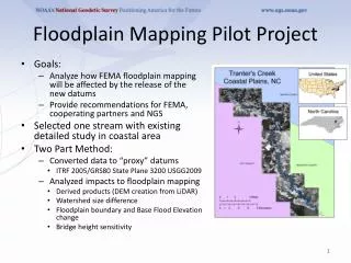
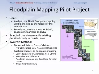
Former river structures dyke Thin forest Floodplain Krosno Odranskie flooded (6.8.1997) canal ditch Former river structure Floodplain Management • Floodplain management requires a characterisation of floodplain structures as well as information about flood extent and river dynamics • Potential of radar-based EO-data was analysed • Flood extent, floodplain structures and flood dynamics were mapped with traditional and interferometric approach • ROI: selected sites in the river Odra floodplain affected by the flood event in 1997
Results • Mapping of the flood extent by using only backscatter information can lead to significant misclassifications (double bounce scattering, corner reflections). • Using additional coherence information of tandem data can avoid this wrong interpretation of the situation. • A better visibility of floodplain structures was detected during flood events. • Detection of morphodynamic activities (e.g. the bursting of meander, accumulation, erosion) difficult because of the medium resolution of the instrument Interferometric signatures Backscatter information Coherence information