1 / 6

TIN of the North East part of campus

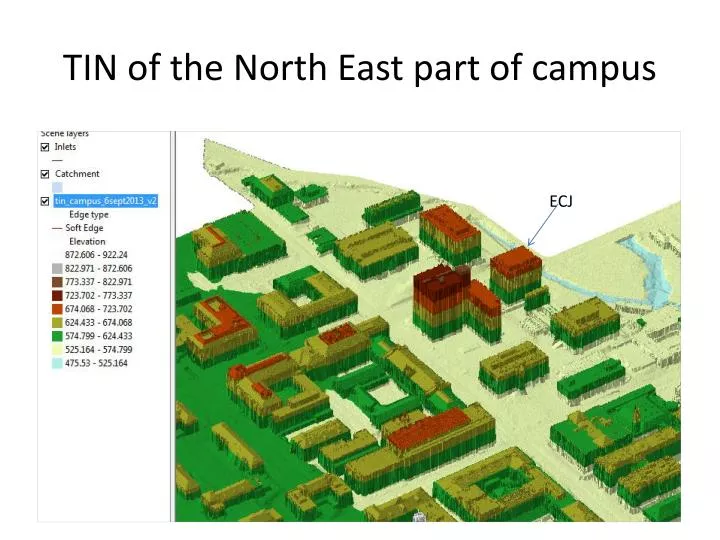
TIN of the North East part of campus. ECJ. Airborne LIDAR coverage of Dean Keaton St and surroundings. CrossSection 56 Location. TIN of a portion of Dean Keaton St. Vehicle-based LIDAR collection at UT-Austin. Mandli Communications. Dean Keaton St. CrossSection 56 Location.

laird
Download Presentation

TIN of the North East part of campus

An Image/Link below is provided (as is) to download presentation Download Policy: Content on the Website is provided to you AS IS for your information and personal use and may not be sold / licensed / shared on other websites without getting consent from its author. Content is provided to you AS IS for your information and personal use only. Download presentation by click this link. While downloading, if for some reason you are not able to download a presentation, the publisher may have deleted the file from their server. During download, if you can't get a presentation, the file might be deleted by the publisher.

E N D

Presentation Transcript


  1. TIN of the North East part of campus ECJ

  2. Airborne LIDAR coverage of Dean Keaton St and surroundings CrossSection 56 Location

  3. TIN of a portion of Dean Keaton St

  4. Vehicle-based LIDAR collection at UT-Austin Mandli Communications

  5. Dean Keaton St CrossSection 56 Location

  6. Road CrossSections from LIDAR Location 5-6 is shown in previous slides Airborne LIDAR (ft) (City of Austin data) Its clear that the vehicle-based LIDAR gives a better definition of the road Cross-Section Vehicle LIDAR (m) (Mandli Communications)

More Related