Download
1 / 19
200 likes | 348 Views
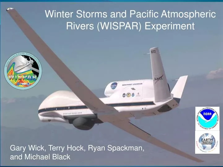
Winter Storms and Pacific Atmospheric Rivers (WISPAR) Experiment. The NOAA Unmanned Aircraft Systems (UAS) Program: Status and Activities . Gary Wick Robbie Hood, Program Director. Gary Wick, Terry Hock, Ryan Spackman , and Michael Black. WISPAR Overview.

E N D
Winter Storms and Pacific Atmospheric Rivers (WISPAR) Experiment The NOAA Unmanned Aircraft Systems (UAS) Program:Status and Activities Gary Wick Robbie Hood, Program Director Gary Wick, Terry Hock, Ryan Spackman, and Michael Black
WISPAR Overview • Funded by the NOAA Unmanned Aircraft Systems (UAS) Program • Primary objective to evaluate the capabilities of the Global Hawk aircraft and NCAR/NOAA dropsonde system for NOAA operations and research • 3 Science flights targeting: • Atmospheric Rivers • Winter Storms Reconnaissance • Arctic Weather • January – March 2011 from NASA Dryden Flight Research Facility • 177 dropsondes deployed in just under 70 flight hours
Atmospheric Rivers Flight • Objective: Observe and characterize an atmospheric river with a strong tropical connection near Hawaii • 11-12 February 2011, 20:25 flight • HMT IOP 3, 14-17 February • Planned flight elements: • Core transit • 4 transects • Water vapor budget box • Flight terminated at start of third transect due to engine fault • 37 sondes deployed
Initial Flight Plan Atmospheric river flight: 11 – 12 February 2011 Flight plan shown in Waypoint Planning Tool overlaid on GFS forecast of precipitable water valid midway through flight
Dropsonde Location and Status 00 Z Analysis, 12 February 2011 SSMIS F18, 12 Feb 2011, ~0530 UTC GH Position GH Position
AR Width – First Transect 0336Z 0306Z 0217Z
AR Core – Second Transect 0622Z 0630Z 0646Z Surface to ~550 mb also available from incomplete sounding in middle of core
Winter Storms Flight • Primary Objective: WSR targeted observations in support of forecasted cyclogenesis in the Midwest on 6 March • Secondary objective: Additional transect of a weak AR event (low IWV but strong winds) • 3-4 March 2011, 24:08 flight • HMT IOP 6, 1-4 March • HMT IOP 7, 6-7 March • 70 sondes deployed • Flight conducted in coordination with G-IV WSR flight • G-IV conducted AR transect and water vapor budget box
Synoptic Conditions • Screen shot at 0245 UTC from NASA RTMM • Background is GOES-West IR imagery • G-IV flight plan visible at bottom left Intensifying Low Pressure System GH
Winter Storms Objective Sensitivity Forecast Valid 00Z Mar 4 (colors) Valid 12Z Mar 4 (contours)
AR Crossings - Dropsonde Status SSMIS F18, 04 March 2011, ~0500 UTC SSMIS F16-17, 04 Mar2011, ~1600 UTC GH Position GH Position
Arctic Flight • Objectives: • Operational demonstration of Arctic weather sampling • Comparison with ground observations from Barrow site • Sampling within the Arctic vortex • 2 high-density transects of an atmospheric river • 9-10 March 2011, 25:03 flight • Due to longer required lead times, GloPac flight plan utilized • Aircraft forced to descend to 45,000 ft at 78 N due to cold ambient temperatures • 70 sondes deployed • 35 in Arctic north of Alaska • 27 in 2 AR transects
AR Crossings – Dropsonde Status Northbound AR Segment 00 Z Analysis, 10 March 2011 SSMIS F17 10 Mar 2011, ~0200 UTC GH Position GH Position
AR Crossings – Dropsonde Status Southbound AR Segment 18 Z Analysis, 10 March 2011 SSMIS F16, 10 Mar 2011, ~1600 UTC GH Position GH Position
Northbound AR Transect 2315Z SSMIS F17 10 Mar 2011, ~0200 UTC 2310Z 2305Z
Southbound AR Transect 1839Z SSMIS F16, 10 Mar 2011, ~1600 UTC 1843Z 1906Z
Arctic Observations Drop locations superimposed on 70 mb temperatures from the NCAR/NCEP V2 reanalysis data Courtesy of Leslie Lait, Paul Newman (NASA GSFC)
Summary • Overall an excellent engineering test and operational demonstration • Dropsonde system performed extremely well • Significant mission flexibility observed • Two flights corresponded to conditions in advance of CalWater IOPs • Results will be available to interested CalWater investigators • Good science expected